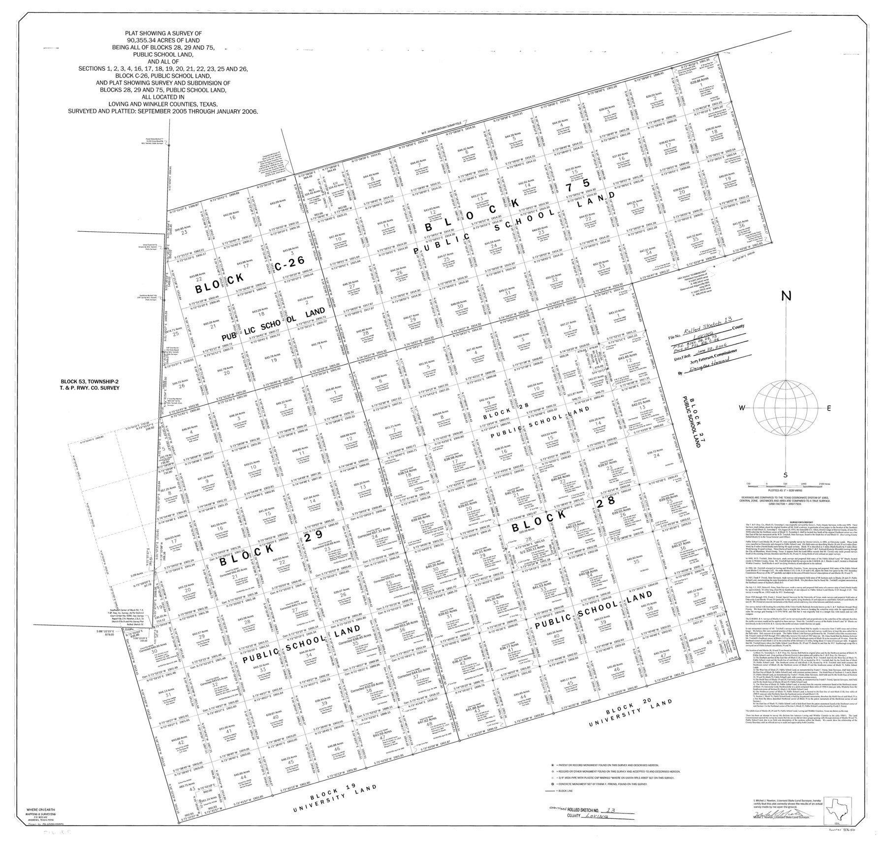
Loving County Rolled Sketch 13
Plat showing a survey of 90,355.34 acres of land being all of Blocks 28, 29 and 75, Public School Land and all of sections 1, 2, 3, 4, 16, 17, 18, 19, 20, 21, 22, 23, 25 and 26, Block C-26 and plat showing survey and subdivision of Blocks 28, 29 and 75
-
Map/Doc
83650
-
Collection
General Map Collection
-
Object Dates
1/2006 (Creation Date)
6/22/2006 (File Date)
-
People and Organizations
Michael J. Newton (Surveyor/Engineer)
-
Counties
Loving Winkler
-
Subjects
Surveying Rolled Sketch
-
Height x Width
43.6 x 45.0 inches
110.7 x 114.3 cm
-
Medium
mylar, print
-
Scale
1" = 828 varas
Part of: General Map Collection
Montague County Sketch File 21

Print $4.00
- Digital $50.00
Montague County Sketch File 21
1888
Size 12.4 x 8.3 inches
Map/Doc 31751
Map of Harris County

Print $40.00
- Digital $50.00
Map of Harris County
1897
Size 48.4 x 66.9 inches
Map/Doc 82068
Flight Mission No. DCL-7C, Frame 71, Kenedy County

Print $20.00
- Digital $50.00
Flight Mission No. DCL-7C, Frame 71, Kenedy County
1943
Size 15.5 x 15.1 inches
Map/Doc 86057
Dimmit County Sketch File 47

Print $24.00
- Digital $50.00
Dimmit County Sketch File 47
1908
Size 11.2 x 9.0 inches
Map/Doc 21178
Houston County Rolled Sketch 7

Print $40.00
- Digital $50.00
Houston County Rolled Sketch 7
Size 43.2 x 50.1 inches
Map/Doc 9183
Crosby County

Print $20.00
- Digital $50.00
Crosby County
1927
Size 36.1 x 32.4 inches
Map/Doc 77255
Flight Mission No. DQN-1K, Frame 80, Calhoun County

Print $20.00
- Digital $50.00
Flight Mission No. DQN-1K, Frame 80, Calhoun County
1953
Size 18.4 x 22.1 inches
Map/Doc 84165
Flight Mission No. DAG-23K, Frame 141, Matagorda County

Print $20.00
- Digital $50.00
Flight Mission No. DAG-23K, Frame 141, Matagorda County
1953
Size 18.7 x 22.4 inches
Map/Doc 86489
Map of Nacogdoches County

Print $20.00
- Digital $50.00
Map of Nacogdoches County
1881
Size 24.0 x 21.3 inches
Map/Doc 4602
Throckmorton County Working Sketch Graphic Index

Print $20.00
- Digital $50.00
Throckmorton County Working Sketch Graphic Index
1943
Size 44.6 x 36.3 inches
Map/Doc 76713
Hall County Sketch File B and B1

Print $14.00
- Digital $50.00
Hall County Sketch File B and B1
Size 9.2 x 8.5 inches
Map/Doc 24780
Dallas County Rolled Sketch 3

Print $40.00
- Digital $50.00
Dallas County Rolled Sketch 3
1953
Size 30.7 x 78.5 inches
Map/Doc 8767
You may also like
Frio County Working Sketch Graphic Index

Print $20.00
- Digital $50.00
Frio County Working Sketch Graphic Index
1944
Size 43.0 x 41.4 inches
Map/Doc 76549
University Lands Blocks 34 to 37, Terrell County, Isogonic Chart & Meridian Changes

Print $20.00
- Digital $50.00
University Lands Blocks 34 to 37, Terrell County, Isogonic Chart & Meridian Changes
Size 23.2 x 22.4 inches
Map/Doc 62940
Railroad Track Map, H&TCRRCo., Falls County, Texas

Print $4.00
- Digital $50.00
Railroad Track Map, H&TCRRCo., Falls County, Texas
1918
Size 11.7 x 18.5 inches
Map/Doc 62843

Wichita County Working Sketch 3

Print $20.00
- Digital $50.00
Wichita County Working Sketch 3
1913
Size 22.2 x 15.6 inches
Map/Doc 72512
Marion County Rolled Sketch 5

Print $20.00
- Digital $50.00
Marion County Rolled Sketch 5
1961
Size 22.6 x 20.5 inches
Map/Doc 6658
[Working Sketch in Martin County Showing Northwest Portion of County]
![91355, [Working Sketch in Martin County Showing Northwest Portion of County], Twichell Survey Records](https://historictexasmaps.com/wmedia_w700/maps/91355-1.tif.jpg)
Print $20.00
- Digital $50.00
[Working Sketch in Martin County Showing Northwest Portion of County]
1902
Size 17.1 x 36.0 inches
Map/Doc 91355
Atascosa County Sketch File 28

Print $40.00
- Digital $50.00
Atascosa County Sketch File 28
1878
Size 27.9 x 21.7 inches
Map/Doc 10862
[Blks A, B and C, and Irion, Floyd, Sutton and Lubbock County School Land Leagues]
![90202, [Blks A, B and C, and Irion, Floyd, Sutton and Lubbock County School Land Leagues], Twichell Survey Records](https://historictexasmaps.com/wmedia_w700/maps/90202-1.tif.jpg)
Print $20.00
- Digital $50.00
[Blks A, B and C, and Irion, Floyd, Sutton and Lubbock County School Land Leagues]
Size 15.6 x 19.2 inches
Map/Doc 90202
[Map of Townsite of Swearingen, Cottle County, Texas]
![4465, [Map of Townsite of Swearingen, Cottle County, Texas], Maddox Collection](https://historictexasmaps.com/wmedia_w700/maps/4465.tif.jpg)
Print $20.00
- Digital $50.00
[Map of Townsite of Swearingen, Cottle County, Texas]
Size 28.8 x 17.8 inches
Map/Doc 4465
D. B. Gardner vs. Mrs. Clara C. Starr

Print $20.00
- Digital $50.00
D. B. Gardner vs. Mrs. Clara C. Starr
Size 16.3 x 28.5 inches
Map/Doc 91044
Jones County Sketch File 13a

Print $4.00
- Digital $50.00
Jones County Sketch File 13a
Size 8.3 x 15.0 inches
Map/Doc 28499