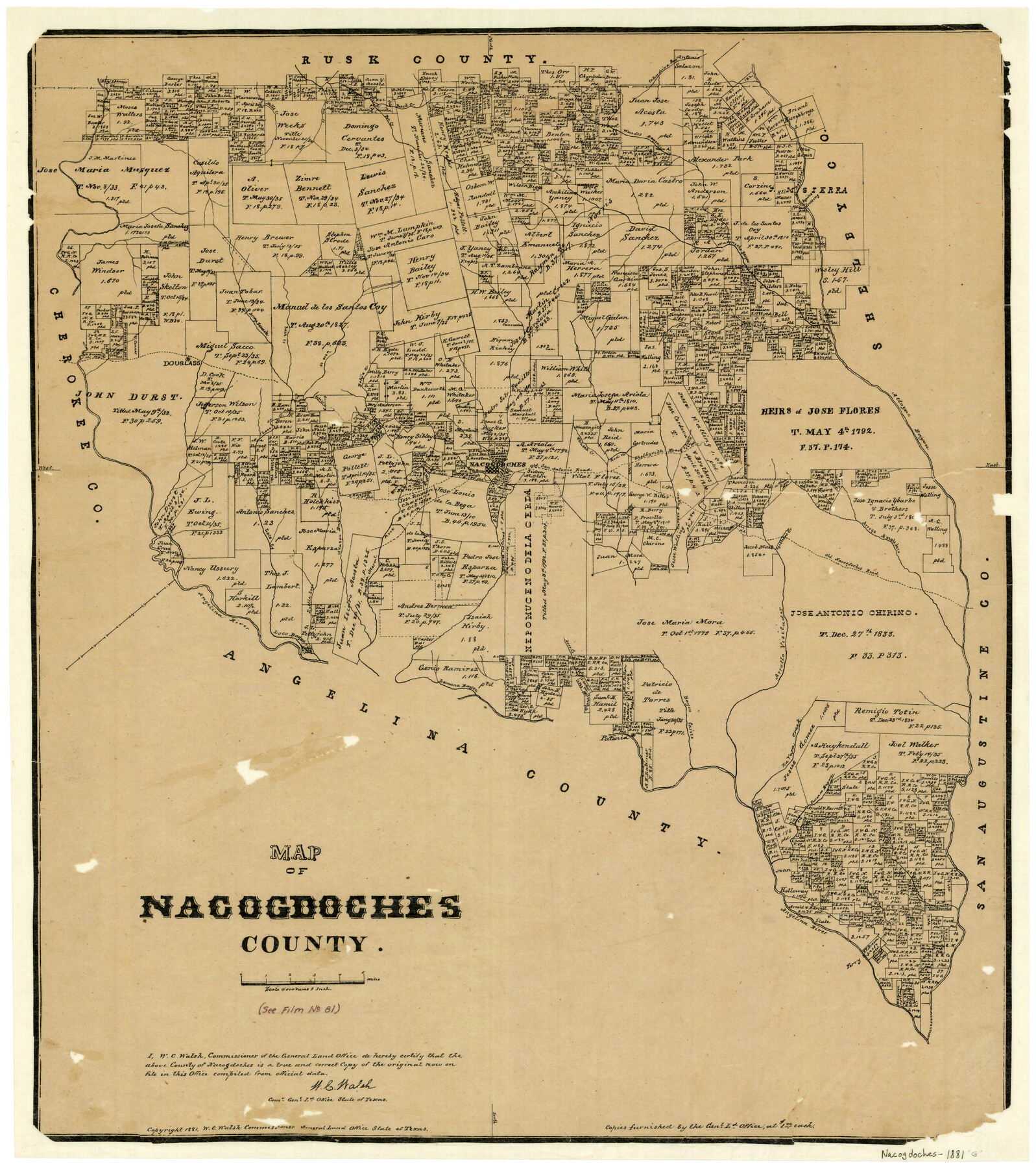
Map of Nacogdoches County
-
Map/Doc
4602
-
Collection
General Map Collection
-
Object Dates
1881 (Creation Date)
-
People and Organizations
Texas General Land Office (Publisher)
W.C. Walsh (GLO Commissioner)
G.N. Beaumont (Compiler)
G.N. Beaumont (Draftsman)
August Gast & Co. (Lithographer)
-
Counties
Nacogdoches
-
Subjects
County
-
Height x Width
24.0 x 21.3 inches
61.0 x 54.1 cm
-
Features
Little Loco Creek
Old San Antonio Road
Shelbyville Road
Arroya Amaladero
Agillitas Creek
Melrose
Old Nacogdoches Road
Carozo Bayou
Alazon Bayou
Bayou Morell
Red Creek
Angelina River
Loco Bayou
Lamana Bayou
Dorr Creek
Bayou Carizo
Arrollo Visitador
La Vaca Creek
Sandy Creek
Douglass
Aycilas Crossing
Nacogdoches
Patonia
Durazno Bayou
Bills Creek
Pen Creek
Beeck Creek
Wandes Bayou
Nacaniche Bayou
Colondrina Bayou
Raiz Creek
Arroya Nasosote
Loco Creek
Rota Creek
Bolija Creek
Cany Creek
Attoyac Bayou
White Oak Creek
Part of: General Map Collection
Angelina County Sketch File 13

Print $4.00
- Digital $50.00
Angelina County Sketch File 13
1860
Size 13.0 x 8.2 inches
Map/Doc 12957
Uvalde County Sketch File 9

Print $4.00
- Digital $50.00
Uvalde County Sketch File 9
Size 6.8 x 8.8 inches
Map/Doc 38967
Runnels County Rolled Sketch 36

Print $40.00
- Digital $50.00
Runnels County Rolled Sketch 36
Size 61.2 x 43.0 inches
Map/Doc 76027
Map of Bryan, Brazos County, Texas

Print $20.00
- Digital $50.00
Map of Bryan, Brazos County, Texas
1915
Size 18.5 x 24.6 inches
Map/Doc 3210
Zavala County Sketch File 23

Print $4.00
- Digital $50.00
Zavala County Sketch File 23
1885
Size 14.4 x 8.8 inches
Map/Doc 41380
Van Zandt County Working Sketch 11

Print $20.00
- Digital $50.00
Van Zandt County Working Sketch 11
1982
Size 15.2 x 9.3 inches
Map/Doc 72261
Runnels County Working Sketch 9

Print $40.00
- Digital $50.00
Runnels County Working Sketch 9
1948
Size 48.8 x 30.1 inches
Map/Doc 69712
Coryell County Sketch File 15

Print $4.00
- Digital $50.00
Coryell County Sketch File 15
1873
Size 13.0 x 8.5 inches
Map/Doc 19371
Travis County Appraisal District Plat Map 2_0018

Print $20.00
- Digital $50.00
Travis County Appraisal District Plat Map 2_0018
Size 21.6 x 26.5 inches
Map/Doc 94208
Presidio County Rolled Sketch 22

Print $20.00
- Digital $50.00
Presidio County Rolled Sketch 22
1885
Size 37.7 x 28.7 inches
Map/Doc 7331
Edwards County Sketch File 16a

Print $24.00
- Digital $50.00
Edwards County Sketch File 16a
1903
Size 14.3 x 8.8 inches
Map/Doc 21720
La Salle County Working Sketch 56

Print $20.00
- Digital $50.00
La Salle County Working Sketch 56
2012
Size 25.5 x 23.0 inches
Map/Doc 93277
You may also like
Il Texas: La Ferrovia New York Texas-Messicana, La Colonizzazione Italiana della costa del Texas

Print $20.00
- Digital $50.00
Il Texas: La Ferrovia New York Texas-Messicana, La Colonizzazione Italiana della costa del Texas
1881
Size 17.6 x 22.0 inches
Map/Doc 97406
McLennan County Sketch File 1

Print $4.00
- Digital $50.00
McLennan County Sketch File 1
Size 11.5 x 8.4 inches
Map/Doc 31224
Map of Webb Co.

Print $20.00
- Digital $50.00
Map of Webb Co.
1901
Size 40.4 x 47.1 inches
Map/Doc 16919
Brazoria County Sketch File 20

Print $40.00
- Digital $50.00
Brazoria County Sketch File 20
1853
Size 22.3 x 15.0 inches
Map/Doc 10953
Flight Mission No. CGI-3N, Frame 167, Cameron County

Print $20.00
- Digital $50.00
Flight Mission No. CGI-3N, Frame 167, Cameron County
1954
Size 18.6 x 22.4 inches
Map/Doc 84631
Polk County Working Sketch 37

Print $20.00
- Digital $50.00
Polk County Working Sketch 37
1974
Size 31.3 x 38.2 inches
Map/Doc 71654
General Highway Map, Kleberg County, Texas

Print $20.00
General Highway Map, Kleberg County, Texas
1940
Size 24.7 x 18.2 inches
Map/Doc 79164
Flight Mission No. BRA-3M, Frame 125, Jefferson County

Print $20.00
- Digital $50.00
Flight Mission No. BRA-3M, Frame 125, Jefferson County
1953
Size 18.6 x 21.5 inches
Map/Doc 85399
Mapa de toda la Frontera de los dominios del Rey en la America septentrional

Print $40.00
Mapa de toda la Frontera de los dominios del Rey en la America septentrional
1771
Size 26.4 x 50.0 inches
Map/Doc 95311

Flight Mission No. BQY-15M, Frame 14, Harris County

Print $20.00
- Digital $50.00
Flight Mission No. BQY-15M, Frame 14, Harris County
1953
Size 18.6 x 22.4 inches
Map/Doc 85312
Erath County Sketch File A

Print $4.00
- Digital $50.00
Erath County Sketch File A
Size 8.6 x 11.0 inches
Map/Doc 22249