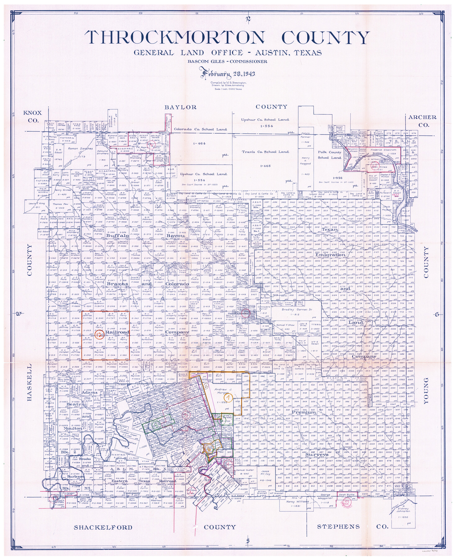
Throckmorton County Working Sketch Graphic Index
-
Map/Doc
76713
-
Collection
General Map Collection
-
Object Dates
2/28/1943 (Creation Date)
-
People and Organizations
W. S. Brewington (Compiler)
Eltea Armstrong (Draftsman)
-
Counties
Throckmorton
-
Subjects
County Surveying Working Sketch
-
Height x Width
44.6 x 36.3 inches
113.3 x 92.2 cm
-
Medium
blueprint/diazo
-
Scale
1" = 2000 varas
Part of: General Map Collection
Hale County Sketch File 12

Print $20.00
- Digital $50.00
Hale County Sketch File 12
Size 46.0 x 38.2 inches
Map/Doc 10469
San Patricio County Rolled Sketch 17A

Print $20.00
- Digital $50.00
San Patricio County Rolled Sketch 17A
1917
Size 15.7 x 23.8 inches
Map/Doc 7575
Montgomery County Working Sketch 36

Print $20.00
- Digital $50.00
Montgomery County Working Sketch 36
1953
Size 34.6 x 34.5 inches
Map/Doc 71143
Brewster County Rolled Sketch 46

Print $20.00
- Digital $50.00
Brewster County Rolled Sketch 46
Size 20.8 x 32.2 inches
Map/Doc 5222
Galveston County NRC Article 33.136 Sketch 94

Print $72.00
Galveston County NRC Article 33.136 Sketch 94
2024
Map/Doc 97293
Austin County Rolled Sketch 4

Print $20.00
- Digital $50.00
Austin County Rolled Sketch 4
Size 30.8 x 44.8 inches
Map/Doc 8435
Kenedy County Rolled Sketch 3

Print $40.00
- Digital $50.00
Kenedy County Rolled Sketch 3
1904
Size 40.1 x 57.4 inches
Map/Doc 9329
Refugio County Working Sketch 10

Print $20.00
- Digital $50.00
Refugio County Working Sketch 10
1941
Size 43.0 x 30.1 inches
Map/Doc 63519
Carte d'une partie de la Syrie et de la Palestine

Print $20.00
- Digital $50.00
Carte d'une partie de la Syrie et de la Palestine
1782
Size 12.8 x 17.9 inches
Map/Doc 97121
Shelby County Working Sketch 31a

Print $40.00
- Digital $50.00
Shelby County Working Sketch 31a
2003
Size 32.6 x 70.2 inches
Map/Doc 78643
Gaines County Boundary File 3

Print $5.00
- Digital $50.00
Gaines County Boundary File 3
Size 13.9 x 9.1 inches
Map/Doc 53654
Flight Mission No. CUG-3P, Frame 142, Kleberg County

Print $20.00
- Digital $50.00
Flight Mission No. CUG-3P, Frame 142, Kleberg County
1956
Size 18.7 x 22.3 inches
Map/Doc 86277
You may also like
Culberson County Sketch File 21

Print $20.00
- Digital $50.00
Culberson County Sketch File 21
1937
Size 11.2 x 8.8 inches
Map/Doc 20224
[S. M. Walker, D. P. Allen, J. C. Guinn, J. R. Lamar and surrounding surveys]
![90335, [S. M. Walker, D. P. Allen, J. C. Guinn, J. R. Lamar and surrounding surveys], Twichell Survey Records](https://historictexasmaps.com/wmedia_w700/maps/90335-1.tif.jpg)
Print $3.00
- Digital $50.00
[S. M. Walker, D. P. Allen, J. C. Guinn, J. R. Lamar and surrounding surveys]
1912
Size 9.8 x 11.3 inches
Map/Doc 90335
Reeves County Sketch File 6

Print $20.00
- Digital $50.00
Reeves County Sketch File 6
Size 17.3 x 28.3 inches
Map/Doc 12242
Hudspeth County Rolled Sketch 54

Print $177.00
- Digital $50.00
Hudspeth County Rolled Sketch 54
1977
Size 10.2 x 15.0 inches
Map/Doc 45887
Brazoria County Rolled Sketch 39

Print $20.00
- Digital $50.00
Brazoria County Rolled Sketch 39
1949
Size 22.8 x 34.8 inches
Map/Doc 5174
Flight Mission No. BRE-2P, Frame 15, Nueces County

Print $20.00
- Digital $50.00
Flight Mission No. BRE-2P, Frame 15, Nueces County
1956
Size 18.4 x 22.4 inches
Map/Doc 86724
Menard County Sketch File 8

Print $20.00
- Digital $50.00
Menard County Sketch File 8
Size 19.7 x 28.5 inches
Map/Doc 12073
Wharton County Sketch File 13a

Print $20.00
- Digital $50.00
Wharton County Sketch File 13a
1894
Size 18.3 x 28.7 inches
Map/Doc 12663
Map of Hardin County, Texas

Print $20.00
- Digital $50.00
Map of Hardin County, Texas
1895
Size 22.1 x 20.9 inches
Map/Doc 499
[John H. Stephens Blk. S-2, Capitol Lgs. to North and County School to the South]
![90241, [John H. Stephens Blk. S-2, Capitol Lgs. to North and County School to the South], Twichell Survey Records](https://historictexasmaps.com/wmedia_w700/maps/90241-1.tif.jpg)
Print $20.00
- Digital $50.00
[John H. Stephens Blk. S-2, Capitol Lgs. to North and County School to the South]
1903
Size 20.7 x 18.3 inches
Map/Doc 90241
Karnes County Working Sketch 9

Print $20.00
- Digital $50.00
Karnes County Working Sketch 9
1962
Size 37.1 x 28.9 inches
Map/Doc 66657
Midland County Working Sketch 26

Print $20.00
- Digital $50.00
Midland County Working Sketch 26
1962
Size 24.8 x 28.6 inches
Map/Doc 71007