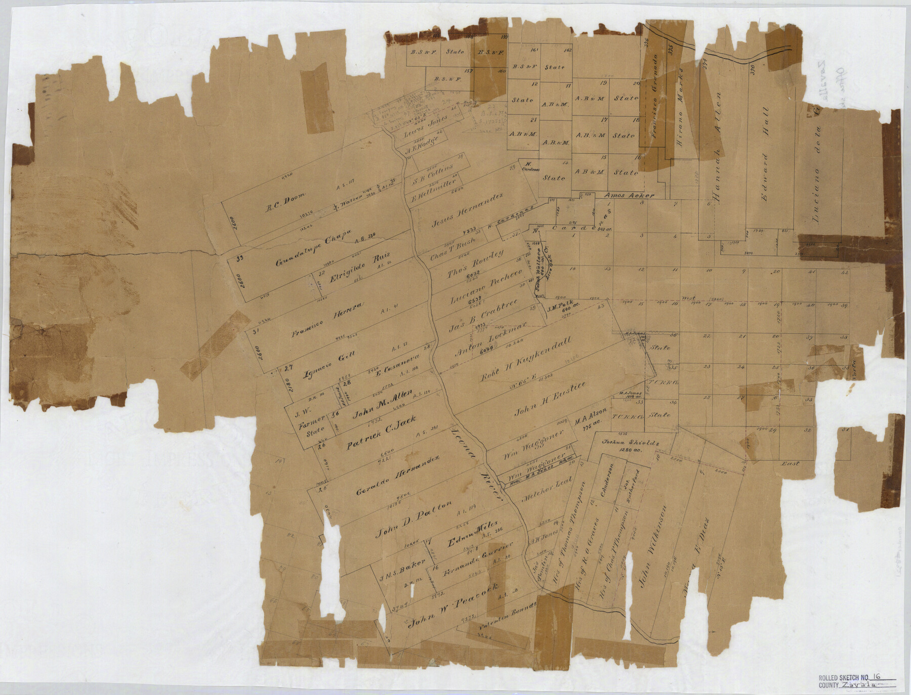
Zavala County Rolled Sketch 16
[Office sketch of surveys in the northeast part of Zavala County, Texas]
-
Map/Doc
8321
-
Collection
General Map Collection
-
Counties
Zavala
-
Subjects
Surveying Rolled Sketch
-
Height x Width
19.4 x 25.4 inches
49.3 x 64.5 cm
-
Medium
paper, manuscript
Part of: General Map Collection
Rusk County Sketch File Y

Print $6.00
Rusk County Sketch File Y
1845
Size 16.7 x 11.0 inches
Map/Doc 35537
Flight Mission No. DCL-6C, Frame 26, Kenedy County

Print $20.00
- Digital $50.00
Flight Mission No. DCL-6C, Frame 26, Kenedy County
1943
Size 18.7 x 22.5 inches
Map/Doc 85883
West Part of Liberty Co.

Print $20.00
- Digital $50.00
West Part of Liberty Co.
1977
Size 46.2 x 35.5 inches
Map/Doc 73220
Texas State Boundary Line 7

Print $182.00
Texas State Boundary Line 7
2000
Size 11.2 x 8.8 inches
Map/Doc 75018
Jefferson County Rolled Sketch 61A

Print $20.00
- Digital $50.00
Jefferson County Rolled Sketch 61A
1928
Size 27.2 x 40.4 inches
Map/Doc 6410
La Salle County Working Sketch 14

Print $20.00
- Digital $50.00
La Salle County Working Sketch 14
1941
Size 37.8 x 36.7 inches
Map/Doc 70315
San Jacinto River and Tributaries, Texas - Survey of 1939

Print $20.00
- Digital $50.00
San Jacinto River and Tributaries, Texas - Survey of 1939
1939
Size 28.1 x 40.5 inches
Map/Doc 3153
Jefferson County Rolled Sketch 8A

Print $20.00
- Digital $50.00
Jefferson County Rolled Sketch 8A
1928
Size 35.6 x 46.3 inches
Map/Doc 76030
Dickens County

Print $20.00
- Digital $50.00
Dickens County
1915
Size 42.4 x 39.3 inches
Map/Doc 4722
Flight Mission No. DQN-1K, Frame 81, Calhoun County

Print $20.00
- Digital $50.00
Flight Mission No. DQN-1K, Frame 81, Calhoun County
1953
Size 18.4 x 22.1 inches
Map/Doc 84166
Upshur County Working Sketch 6

Print $20.00
- Digital $50.00
Upshur County Working Sketch 6
1943
Size 28.6 x 34.3 inches
Map/Doc 69562
Limestone County Working Sketch 10

Print $20.00
- Digital $50.00
Limestone County Working Sketch 10
1922
Size 21.1 x 10.0 inches
Map/Doc 70560
You may also like
Crane County, Texas

Print $20.00
- Digital $50.00
Crane County, Texas
1889
Size 22.5 x 18.0 inches
Map/Doc 721
Concho County Rolled Sketch 16

Print $20.00
- Digital $50.00
Concho County Rolled Sketch 16
1961
Size 24.2 x 15.7 inches
Map/Doc 5551
Mason County Sketch File 11

Print $8.00
- Digital $50.00
Mason County Sketch File 11
1883
Size 13.5 x 8.6 inches
Map/Doc 30695
Throckmorton County

Print $20.00
- Digital $50.00
Throckmorton County
1885
Size 24.9 x 18.7 inches
Map/Doc 4080
Cottle County Working Sketch 12

Print $20.00
- Digital $50.00
Cottle County Working Sketch 12
1959
Size 39.1 x 25.7 inches
Map/Doc 68322
Working Sketch Bastrop County

Print $3.00
- Digital $50.00
Working Sketch Bastrop County
1923
Size 11.0 x 16.2 inches
Map/Doc 90207
Bandera County Working Sketch 56

Print $20.00
- Digital $50.00
Bandera County Working Sketch 56
1991
Size 28.1 x 35.1 inches
Map/Doc 67652
Starr County Working Sketch 1

Print $40.00
- Digital $50.00
Starr County Working Sketch 1
Size 26.7 x 65.5 inches
Map/Doc 63917
Archer County Working Sketch 4

Print $40.00
- Digital $50.00
Archer County Working Sketch 4
1918
Size 49.9 x 68.3 inches
Map/Doc 67144
Polk County Sketch File 17

Print $4.00
- Digital $50.00
Polk County Sketch File 17
1861
Size 8.1 x 9.5 inches
Map/Doc 34163
Upton County Sketch File 7

Print $4.00
- Digital $50.00
Upton County Sketch File 7
Size 14.4 x 8.9 inches
Map/Doc 38820
Kimble County Working Sketch 89

Print $20.00
- Digital $50.00
Kimble County Working Sketch 89
1979
Size 41.2 x 33.2 inches
Map/Doc 70157