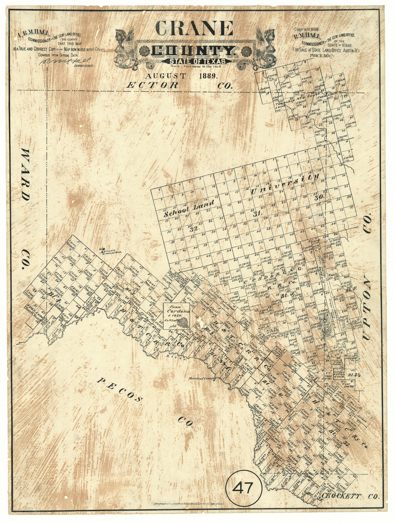
Crane County, Texas
-
Map/Doc
721
-
Collection
Maddox Collection
-
Object Dates
8/1889 (Creation Date)
-
People and Organizations
General Land Office (Publisher)
R.M. Hall (GLO Commissioner)
August Gast Bank Note & Lithograph Company (Lithographer)
-
Counties
Crane
-
Subjects
County
-
Height x Width
22.5 x 18.0 inches
57.2 x 45.7 cm
-
Medium
paper, etching/engraving/lithograph
-
Scale
1" = 4000 varas
-
Comments
Adopted with contributions from the 2010 State Employee Charitable Campaign (SECC).
-
Features
Salt Lake
Pecos River
Horsehead Crossing
Part of: Maddox Collection
Map of Madison County, Texas

Print $20.00
- Digital $50.00
Map of Madison County, Texas
1879
Size 17.1 x 21.7 inches
Map/Doc 643
[Sketch Showing Loma Blanca , El Tule and San Antonio de Encinal Leagues in Brooks County, Texas]
![624, [Sketch Showing Loma Blanca , El Tule and San Antonio de Encinal Leagues in Brooks County, Texas], Maddox Collection](https://historictexasmaps.com/wmedia_w700/maps/00624.tif.jpg)
Print $3.00
- Digital $50.00
[Sketch Showing Loma Blanca , El Tule and San Antonio de Encinal Leagues in Brooks County, Texas]
Size 9.3 x 14.2 inches
Map/Doc 624
Map showing surveys involved in Cause No. 28888, State vs. Sullivan et al Travis County, Texas

Print $20.00
- Digital $50.00
Map showing surveys involved in Cause No. 28888, State vs. Sullivan et al Travis County, Texas
Size 23.0 x 40.7 inches
Map/Doc 75989
Map of Kerr County, Texas

Print $20.00
- Digital $50.00
Map of Kerr County, Texas
1879
Size 21.7 x 28.5 inches
Map/Doc 526
Map of Briscoe County, Texas

Print $20.00
- Digital $50.00
Map of Briscoe County, Texas
1879
Size 22.6 x 18.0 inches
Map/Doc 614
[Surveying Sketch of T. & N. O. R. R. Co., S. P. R. R. Co., E. T. R. R. Co., et al in Dallam, Hartley, Sherman & Moore Counties, Texas]
![75824, [Surveying Sketch of T. & N. O. R. R. Co., S. P. R. R. Co., E. T. R. R. Co., et al in Dallam, Hartley, Sherman & Moore Counties, Texas], Maddox Collection](https://historictexasmaps.com/wmedia_w700/maps/75824.tif.jpg)
Print $20.00
- Digital $50.00
[Surveying Sketch of T. & N. O. R. R. Co., S. P. R. R. Co., E. T. R. R. Co., et al in Dallam, Hartley, Sherman & Moore Counties, Texas]
Size 17.5 x 22.1 inches
Map/Doc 75824
McCulloch County, Texas

Print $20.00
- Digital $50.00
McCulloch County, Texas
1879
Size 24.6 x 18.0 inches
Map/Doc 573
Part of original sketch of Block "H" W. & N. W. Ry. Co. Cottle County

Print $20.00
- Digital $50.00
Part of original sketch of Block "H" W. & N. W. Ry. Co. Cottle County
Size 13.7 x 14.6 inches
Map/Doc 10776
Map of Survey 10, Block 1, D.B. Gardner

Print $20.00
- Digital $50.00
Map of Survey 10, Block 1, D.B. Gardner
1915
Size 16.1 x 18.7 inches
Map/Doc 10764
[Surveying sketch of J.C. Payne, J.D. Polk, Jos. English, et al in Travis County, Texas]
![75801, [Surveying sketch of J.C. Payne, J.D. Polk, Jos. English, et al in Travis County, Texas], Maddox Collection](https://historictexasmaps.com/wmedia_w700/maps/75801.tif.jpg)
Print $20.00
- Digital $50.00
[Surveying sketch of J.C. Payne, J.D. Polk, Jos. English, et al in Travis County, Texas]
Size 18.3 x 23.5 inches
Map/Doc 75801
Callahan County, Texas

Print $20.00
- Digital $50.00
Callahan County, Texas
1880
Size 24.1 x 18.5 inches
Map/Doc 89276
Survey for H.A. Wroe

Print $20.00
- Digital $50.00
Survey for H.A. Wroe
Size 19.6 x 10.4 inches
Map/Doc 601
You may also like
Flight Mission No. DQO-6K, Frame 33, Galveston County

Print $20.00
- Digital $50.00
Flight Mission No. DQO-6K, Frame 33, Galveston County
1952
Size 18.8 x 22.4 inches
Map/Doc 85099
Stephens County Working Sketch 23

Print $20.00
- Digital $50.00
Stephens County Working Sketch 23
1975
Size 31.0 x 38.8 inches
Map/Doc 63966
Map Showing Division Line Between Chapman and Mills' Lands

Print $20.00
- Digital $50.00
Map Showing Division Line Between Chapman and Mills' Lands
Size 32.5 x 31.6 inches
Map/Doc 92848

Jasper County Working Sketch 21

Print $20.00
- Digital $50.00
Jasper County Working Sketch 21
1941
Size 13.1 x 21.4 inches
Map/Doc 66483
Harris County Sketch File 59a

Print $20.00
- Digital $50.00
Harris County Sketch File 59a
Size 25.1 x 40.1 inches
Map/Doc 10479
Live Oak County Sketch File 8

Print $4.00
- Digital $50.00
Live Oak County Sketch File 8
1875
Size 7.6 x 7.9 inches
Map/Doc 30261
Brewster County Rolled Sketch 29
Print $20.00
- Digital $50.00
Brewster County Rolled Sketch 29
1910
Size 17.5 x 18.5 inches
Map/Doc 5216
Flight Mission No. DQN-2K, Frame 142, Calhoun County

Print $20.00
- Digital $50.00
Flight Mission No. DQN-2K, Frame 142, Calhoun County
1953
Size 16.3 x 16.0 inches
Map/Doc 84311
Rusk County Sketch File 16

Print $4.00
Rusk County Sketch File 16
1849
Size 13.0 x 8.4 inches
Map/Doc 35518
Bell County Sketch File 4

Print $40.00
- Digital $50.00
Bell County Sketch File 4
1848
Size 15.9 x 12.6 inches
Map/Doc 14369
Erath County Sketch File 10a

Print $4.00
- Digital $50.00
Erath County Sketch File 10a
1871
Size 8.0 x 12.8 inches
Map/Doc 22277