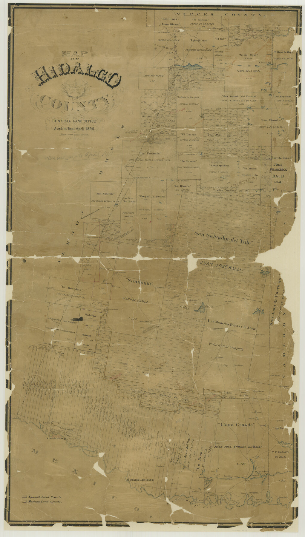
Map of Hidalgo County
-
Map/Doc
4684
-
Collection
General Map Collection
-
Object Dates
1896 (Creation Date)
-
People and Organizations
Texas General Land Office (Publisher)
F.G. Blau (Draftsman)
F.G. Blau (Compiler)
-
Counties
Hidalgo
-
Subjects
County
-
Height x Width
44.9 x 25.5 inches
114.0 x 64.8 cm
-
Comments
Conservation funded in 2002 with donation from Republic Royalty Company.
-
Features
Cibolo Creek
Palo Blanco Creek
Paisano Creek
Los Olmos Creek
La[guna] Tusquita
Laguna Salada
San Antonio Creek
La[guna] de la Jarita
Rancho Gonzalena
Rancho Tepeguajes
Rancho de los Mesquites
Pilar Zarate
Rancho San Francisco
La Cuates de las Vacas
Rancho Las Rucias
Rancho La Blanca
Rancho Santa Quiteria
Tasujica Lake
Rancho San Jose de Arriba
Rancho San Ramon
El Junco Road
Road to Rio Grande City
La[guna] Mestena
La[guna] Pintoballo
Rancho Guadalupe
Rancho Juanita
De la Joya
Rancho Santanita
Rancho El Tule
Rancho EL Rucio
Rancho Costales
Cardaneña
Rancho La Jara
Lago de San Juan
Rancho Lago de Sal Vieja
Rancho San Nicolas
Rancho Santa Monica
Rancho Valla Hermosa
Lago Sal de Rey
Salt Lake
Rancho La Noria
Rancho La Jara
Laguna Seca
Altos Colorados
Rancho Americano
De la Mula
Rancho Matamoros
Rancho Retama
Rancho La Piedra
Rancho Las Petitas
San Matias
Santa Rita
Colimal
Rancho Los Burros
Noria Salado
Alto Verde
Las Cuevas
Rancho Habana
Reynosa Vieja
D. de la Mula
Rancho San Jose
Ovejas
Gediondo
Rancho Tio Cano
Capitanaña
Mala de Maiz
Ojo de Agua
Colorado Creek
Rio Grande del Norte
Rancho de Cabasos
Rancho Laguna Seca
Rancho Tampaguas
Rancho Salto
Falfurias
Rancho Tenajo
D. de Tio Austin
Rancho Ebanito
Sardines Lakes
Hidalgo
Edinburg
Lago de Armagosa
Rancho de los Olmos
Purgatorie
Rancho Naranjado
Rancho de Osa
Job Lake
Badena
Rancho Blanco
Agua Negra
Rancho Reyes
Rosario
Rancho Relampargo
Rancho Balli
Rancho Esterito
Rudyville
Santa Maria
La[guna] Sestiederas
Retama
Reynosa Vieja
La[guna] de San Jose
Rancho Estero de Llano Grande
Rio Grande
Rancho Vieja
Rancho Santa Maria
Part of: General Map Collection
Medina County Sketch File 12

Print $6.00
- Digital $50.00
Medina County Sketch File 12
1907
Size 7.2 x 8.8 inches
Map/Doc 31468
Starr County Working Sketch 19

Print $20.00
- Digital $50.00
Starr County Working Sketch 19
1982
Size 27.3 x 33.9 inches
Map/Doc 63935
Flight Mission No. DCL-7C, Frame 21, Kenedy County

Print $20.00
- Digital $50.00
Flight Mission No. DCL-7C, Frame 21, Kenedy County
1943
Size 15.3 x 15.2 inches
Map/Doc 86013
Tom Green County Sketch File 71

Print $20.00
- Digital $50.00
Tom Green County Sketch File 71
1948
Size 17.5 x 20.6 inches
Map/Doc 12447
Liberty County Working Sketch 36

Print $20.00
- Digital $50.00
Liberty County Working Sketch 36
1948
Size 24.3 x 25.0 inches
Map/Doc 70495
Kaufman County Working Sketch Graphic Index

Print $20.00
- Digital $50.00
Kaufman County Working Sketch Graphic Index
1942
Size 46.1 x 38.3 inches
Map/Doc 76601
Jasper County Working Sketch 2

Print $20.00
- Digital $50.00
Jasper County Working Sketch 2
Size 18.6 x 22.5 inches
Map/Doc 66464
Gaines County Rolled Sketch 29

Print $20.00
- Digital $50.00
Gaines County Rolled Sketch 29
1990
Size 14.7 x 20.5 inches
Map/Doc 5942
Geological Map of the Great East Texas Oil Fields

Print $20.00
- Digital $50.00
Geological Map of the Great East Texas Oil Fields
Size 22.6 x 11.7 inches
Map/Doc 94271
Maps of Gulf Intracoastal Waterway, Texas - Sabine River to the Rio Grande and connecting waterways including ship channels

Print $20.00
- Digital $50.00
Maps of Gulf Intracoastal Waterway, Texas - Sabine River to the Rio Grande and connecting waterways including ship channels
1966
Size 15.6 x 22.0 inches
Map/Doc 61984
Political Essay on the Kingdom of New Spain Vol. 1, Third Edition

Political Essay on the Kingdom of New Spain Vol. 1, Third Edition
1822
Map/Doc 97386
Denton County Working Sketch 5

Print $20.00
- Digital $50.00
Denton County Working Sketch 5
1956
Size 23.9 x 19.4 inches
Map/Doc 68610
You may also like
Sheet 1 copied from Peck Book 6 [Strip Map showing T. & P. connecting lines]
![93169, Sheet 1 copied from Peck Book 6 [Strip Map showing T. & P. connecting lines], Twichell Survey Records](https://historictexasmaps.com/wmedia_w700/maps/93169-1.tif.jpg)
Print $40.00
- Digital $50.00
Sheet 1 copied from Peck Book 6 [Strip Map showing T. & P. connecting lines]
1909
Size 6.8 x 83.1 inches
Map/Doc 93169
Sutton County Working Sketch 42

Print $20.00
- Digital $50.00
Sutton County Working Sketch 42
1950
Size 34.5 x 29.1 inches
Map/Doc 62385
Crane County Working Sketch 7

Print $20.00
- Digital $50.00
Crane County Working Sketch 7
1929
Size 33.6 x 23.2 inches
Map/Doc 68284
Matagorda Bay and Approaches

Print $20.00
- Digital $50.00
Matagorda Bay and Approaches
1992
Size 36.6 x 44.6 inches
Map/Doc 73390
Williamson County Sketch File 8a

Print $4.00
- Digital $50.00
Williamson County Sketch File 8a
1849
Size 10.4 x 8.3 inches
Map/Doc 40320
Liberty County Working Sketch 56

Print $40.00
- Digital $50.00
Liberty County Working Sketch 56
1966
Size 52.0 x 28.4 inches
Map/Doc 70516
Red River County Working Sketch 58

Print $40.00
- Digital $50.00
Red River County Working Sketch 58
1972
Size 51.4 x 39.0 inches
Map/Doc 72041
Travels to the source of the Missouri River and across the American Continent to the Pacific Ocean - Vol. 3

Travels to the source of the Missouri River and across the American Continent to the Pacific Ocean - Vol. 3
1815
Map/Doc 97414
Sabine County Working Sketch 11

Print $20.00
- Digital $50.00
Sabine County Working Sketch 11
1931
Size 30.9 x 34.0 inches
Map/Doc 63682
Kinney County Working Sketch 28

Print $20.00
- Digital $50.00
Kinney County Working Sketch 28
1957
Size 33.3 x 34.4 inches
Map/Doc 70210
Terrell County Rolled Sketch 49

Print $20.00
- Digital $50.00
Terrell County Rolled Sketch 49
1962
Size 17.3 x 24.1 inches
Map/Doc 7951
Reeves County Sketch File 17

Print $40.00
- Digital $50.00
Reeves County Sketch File 17
1943
Size 9.9 x 19.4 inches
Map/Doc 35208