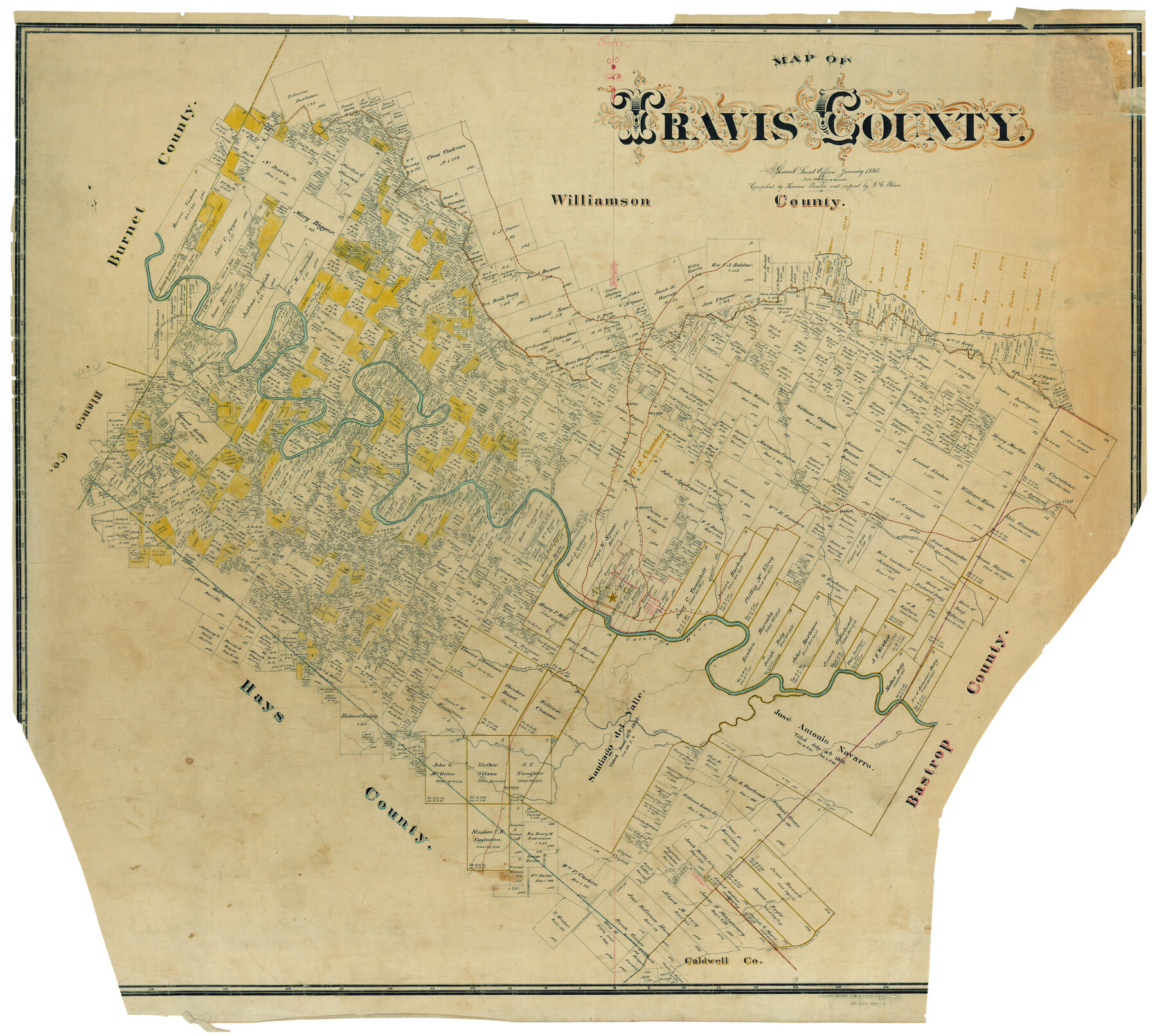
Map of Travis County
-
Map/Doc
82083
-
Collection
General Map Collection
-
Object Dates
1/1895 (Creation Date)
-
People and Organizations
Texas General Land Office (Publisher)
Herman Pressler (Compiler)
F.G. Blau (Draftsman)
-
Counties
Travis
-
Subjects
County
-
Height x Width
48.8 x 54.1 inches
124.0 x 137.4 cm
Part of: General Map Collection
Flight Mission No. BQR-7K, Frame 28, Brazoria County

Print $20.00
- Digital $50.00
Flight Mission No. BQR-7K, Frame 28, Brazoria County
1952
Size 18.5 x 22.2 inches
Map/Doc 84026
Gregg County Sketch File 1A

Print $6.00
- Digital $50.00
Gregg County Sketch File 1A
1847
Size 8.3 x 7.6 inches
Map/Doc 24535
United States Bathymetric and Fishing Maps including Topographic/Bathymetric Maps

Print $40.00
- Digital $50.00
United States Bathymetric and Fishing Maps including Topographic/Bathymetric Maps
1992
Size 21.3 x 55.1 inches
Map/Doc 76127
King County Boundary File 5b

Print $25.00
- Digital $50.00
King County Boundary File 5b
Size 8.7 x 6.9 inches
Map/Doc 64924

Leon County Rolled Sketch 13

Print $20.00
- Digital $50.00
Leon County Rolled Sketch 13
1975
Size 22.8 x 22.5 inches
Map/Doc 6600
Ward County Working Sketch 33

Print $20.00
- Digital $50.00
Ward County Working Sketch 33
1968
Size 26.3 x 32.3 inches
Map/Doc 72339
Fisher County Working Sketch 18

Print $20.00
- Digital $50.00
Fisher County Working Sketch 18
1941
Size 24.7 x 16.6 inches
Map/Doc 69152
Jeff Davis County Rolled Sketch 10

Print $6.00
- Digital $50.00
Jeff Davis County Rolled Sketch 10
1906
Size 29.6 x 30.1 inches
Map/Doc 6363
Flight Mission No. CGI-3N, Frame 177, Cameron County

Print $20.00
- Digital $50.00
Flight Mission No. CGI-3N, Frame 177, Cameron County
1954
Size 18.5 x 22.3 inches
Map/Doc 84641

Frio County Working Sketch 10

Print $20.00
- Digital $50.00
Frio County Working Sketch 10
1951
Size 27.0 x 27.3 inches
Map/Doc 69284
You may also like
Blanco County Working Sketch 18

Print $20.00
- Digital $50.00
Blanco County Working Sketch 18
1912
Size 19.0 x 15.9 inches
Map/Doc 67378
Borden County Sketch File 10b

Print $40.00
- Digital $50.00
Borden County Sketch File 10b
Size 23.0 x 17.0 inches
Map/Doc 10936
Flight Mission No. DAG-14K, Frame 140, Matagorda County

Print $20.00
- Digital $50.00
Flight Mission No. DAG-14K, Frame 140, Matagorda County
1952
Size 17.6 x 17.6 inches
Map/Doc 86307
[Galveston, Harrisburg & San Antonio Railroad from Cuero to Stockdale]
![64184, [Galveston, Harrisburg & San Antonio Railroad from Cuero to Stockdale], General Map Collection](https://historictexasmaps.com/wmedia_w700/maps/64184.tif.jpg)
Print $20.00
- Digital $50.00
[Galveston, Harrisburg & San Antonio Railroad from Cuero to Stockdale]
1906
Size 14.1 x 34.2 inches
Map/Doc 64184
Map Showing Resurvey of Capitol Leagues, Lamb, Cochran & Hockley Co's.

Print $20.00
- Digital $50.00
Map Showing Resurvey of Capitol Leagues, Lamb, Cochran & Hockley Co's.
1918
Size 37.0 x 29.3 inches
Map/Doc 1759
Hill County Boundary File 45

Print $41.00
- Digital $50.00
Hill County Boundary File 45
Size 9.0 x 3.6 inches
Map/Doc 54743
Van Zandt County Sketch File 14

Print $4.00
- Digital $50.00
Van Zandt County Sketch File 14
1858
Size 7.9 x 8.1 inches
Map/Doc 39404
Brazos Santiago, Texas

Print $20.00
- Digital $50.00
Brazos Santiago, Texas
1900
Size 18.3 x 26.9 inches
Map/Doc 73031
Karnes County Sketch File 9

Print $6.00
- Digital $50.00
Karnes County Sketch File 9
1876
Size 12.6 x 8.1 inches
Map/Doc 28594
Jeff Davis County Boundary File 1

Print $18.00
- Digital $50.00
Jeff Davis County Boundary File 1
Size 8.8 x 8.6 inches
Map/Doc 55492
Duval County Rolled Sketch 31

Print $20.00
- Digital $50.00
Duval County Rolled Sketch 31
1948
Size 21.9 x 20.8 inches
Map/Doc 5748
Flight Mission No. BRE-2P, Frame 42, Nueces County

Print $20.00
- Digital $50.00
Flight Mission No. BRE-2P, Frame 42, Nueces County
1956
Size 18.5 x 22.4 inches
Map/Doc 86744