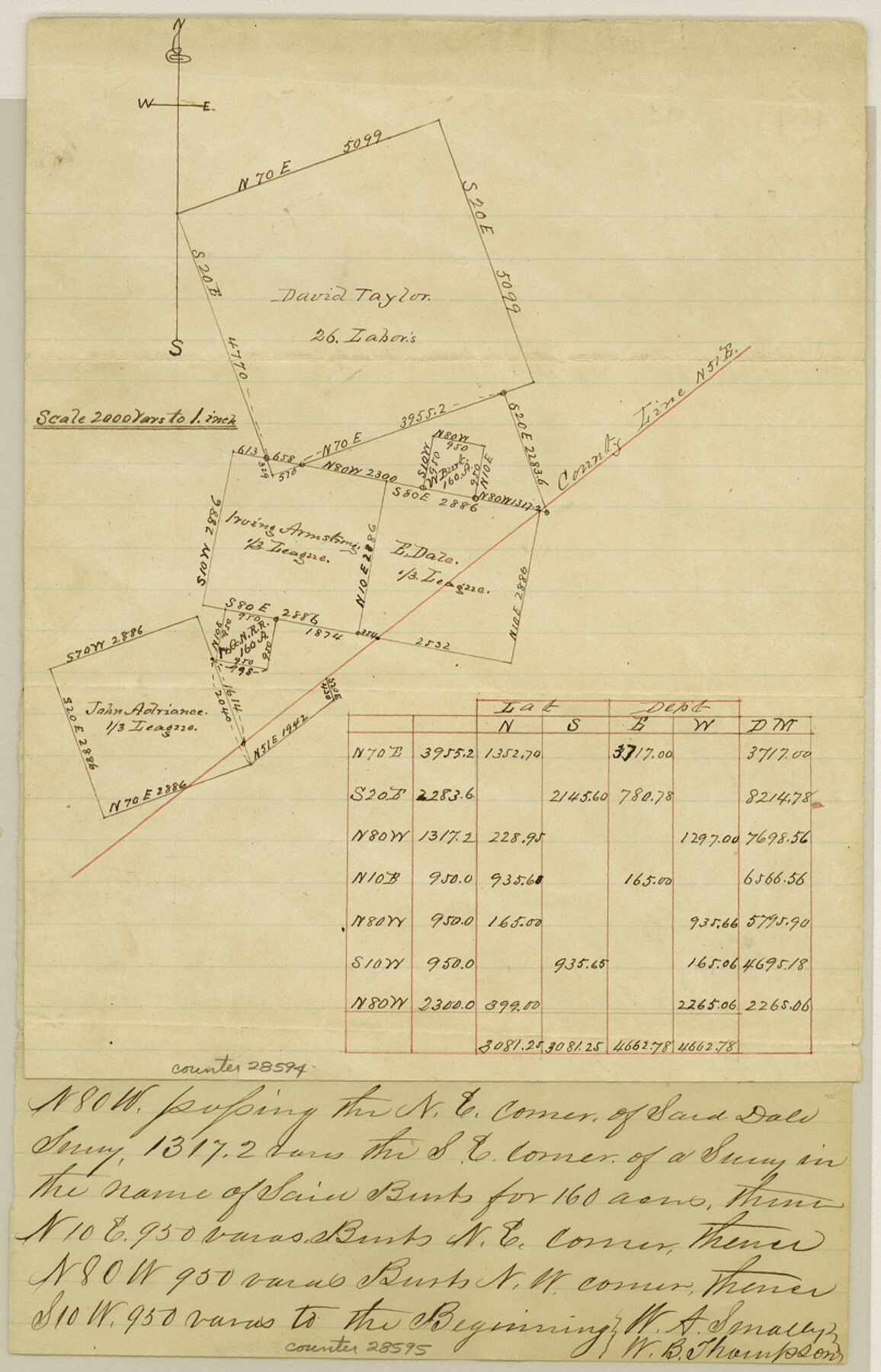
Karnes County Sketch File 9
[Plat and correction field notes for 640 acres in the name of I. & G. N. RR. Co. near DeWitt county line]
-
Map/Doc
28594
-
Collection
General Map Collection
-
Object Dates
6/4/1876 (Creation Date)
-
People and Organizations
W.J. Seale (Surveyor/Engineer)
W.A. Smally (Chainman)
W.B. Thompson (Chainman)
-
Counties
Karnes DeWitt
-
Subjects
Surveying Sketch File
-
Height x Width
12.6 x 8.1 inches
32.0 x 20.6 cm
-
Medium
paper, manuscript
-
Scale
1" = 2000 varas
-
Features
Eclato Creek
San Antonio River
Helena
Part of: General Map Collection
Hall County Sketch File B1

Print $20.00
- Digital $50.00
Hall County Sketch File B1
1904
Size 23.4 x 25.4 inches
Map/Doc 11612
Brazoria County Working Sketch 50a

Print $20.00
- Digital $50.00
Brazoria County Working Sketch 50a
2003
Size 35.0 x 35.2 inches
Map/Doc 78344
Mitchell County Boundary File 3

Print $6.00
- Digital $50.00
Mitchell County Boundary File 3
Size 11.2 x 8.6 inches
Map/Doc 57369
Sabine County Working Sketch 1

Print $20.00
- Digital $50.00
Sabine County Working Sketch 1
1922
Size 17.7 x 17.7 inches
Map/Doc 63672
Irion County Sketch File 18

Print $10.00
- Digital $50.00
Irion County Sketch File 18
Size 11.2 x 8.7 inches
Map/Doc 27494
Gaines County Sketch File 12

Print $4.00
- Digital $50.00
Gaines County Sketch File 12
1950
Size 14.3 x 8.8 inches
Map/Doc 23198
McLennan County Sketch File 20

Print $2.00
- Digital $50.00
McLennan County Sketch File 20
Size 8.0 x 9.1 inches
Map/Doc 31293
Goliad County Working Sketch 18

Print $20.00
- Digital $50.00
Goliad County Working Sketch 18
1949
Size 31.2 x 39.4 inches
Map/Doc 63208
Hardeman County Sketch File 31

Print $4.00
- Digital $50.00
Hardeman County Sketch File 31
Size 14.5 x 9.0 inches
Map/Doc 25066

Flight Mission No. DQO-2K, Frame 91, Galveston County

Print $20.00
- Digital $50.00
Flight Mission No. DQO-2K, Frame 91, Galveston County
1952
Size 18.8 x 22.5 inches
Map/Doc 85018
Marion County Working Sketch 13

Print $20.00
- Digital $50.00
Marion County Working Sketch 13
1953
Size 33.2 x 36.3 inches
Map/Doc 70789
You may also like
Houston County Working Sketch 4

Print $20.00
- Digital $50.00
Houston County Working Sketch 4
1911
Size 15.5 x 21.8 inches
Map/Doc 66234
Flight Mission No. CRC-2R, Frame 135, Chambers County

Print $20.00
- Digital $50.00
Flight Mission No. CRC-2R, Frame 135, Chambers County
1956
Size 18.7 x 22.5 inches
Map/Doc 84751
Gregg County Rolled Sketch JB2

Print $20.00
- Digital $50.00
Gregg County Rolled Sketch JB2
1933
Size 42.0 x 35.1 inches
Map/Doc 8341
Gaines County Working Sketch 12

Print $20.00
- Digital $50.00
Gaines County Working Sketch 12
1954
Size 27.1 x 37.0 inches
Map/Doc 69312
Current Miscellaneous File 31

Print $8.00
- Digital $50.00
Current Miscellaneous File 31
1916
Size 11.2 x 8.7 inches
Map/Doc 73929
Nueces County Navigation District Number One, Submerged Lands Maintained for Navigational Purposes Persuant to Sub-Section G of Section 61.117 Texas Water Code

Print $20.00
- Digital $50.00
Nueces County Navigation District Number One, Submerged Lands Maintained for Navigational Purposes Persuant to Sub-Section G of Section 61.117 Texas Water Code
1975
Size 23.3 x 29.9 inches
Map/Doc 61806
Pecos County Sketch File 80

Print $6.00
- Digital $50.00
Pecos County Sketch File 80
1942
Size 8.9 x 11.9 inches
Map/Doc 33918
Dallam County Working Sketch 4

Print $20.00
- Digital $50.00
Dallam County Working Sketch 4
1974
Size 31.2 x 32.0 inches
Map/Doc 68589
[I. & G. N. Block 1, sections 64, 65, 67-71 and 545 along river]
![91602, [I. & G. N. Block 1, sections 64, 65, 67-71 and 545 along river], Twichell Survey Records](https://historictexasmaps.com/wmedia_w700/maps/91602-1.tif.jpg)
Print $2.00
- Digital $50.00
[I. & G. N. Block 1, sections 64, 65, 67-71 and 545 along river]
Size 8.8 x 14.3 inches
Map/Doc 91602
[R. T. Bucy's Survey 3, League 321]
![91296, [R. T. Bucy's Survey 3, League 321], Twichell Survey Records](https://historictexasmaps.com/wmedia_w700/maps/91296-1.tif.jpg)
Print $20.00
- Digital $50.00
[R. T. Bucy's Survey 3, League 321]
Size 12.2 x 19.1 inches
Map/Doc 91296
Milam County Working Sketch 12

Print $40.00
- Digital $50.00
Milam County Working Sketch 12
Size 44.3 x 56.4 inches
Map/Doc 71027
Sutton County Working Sketch 59

Print $40.00
- Digital $50.00
Sutton County Working Sketch 59
1957
Size 30.2 x 78.4 inches
Map/Doc 62402