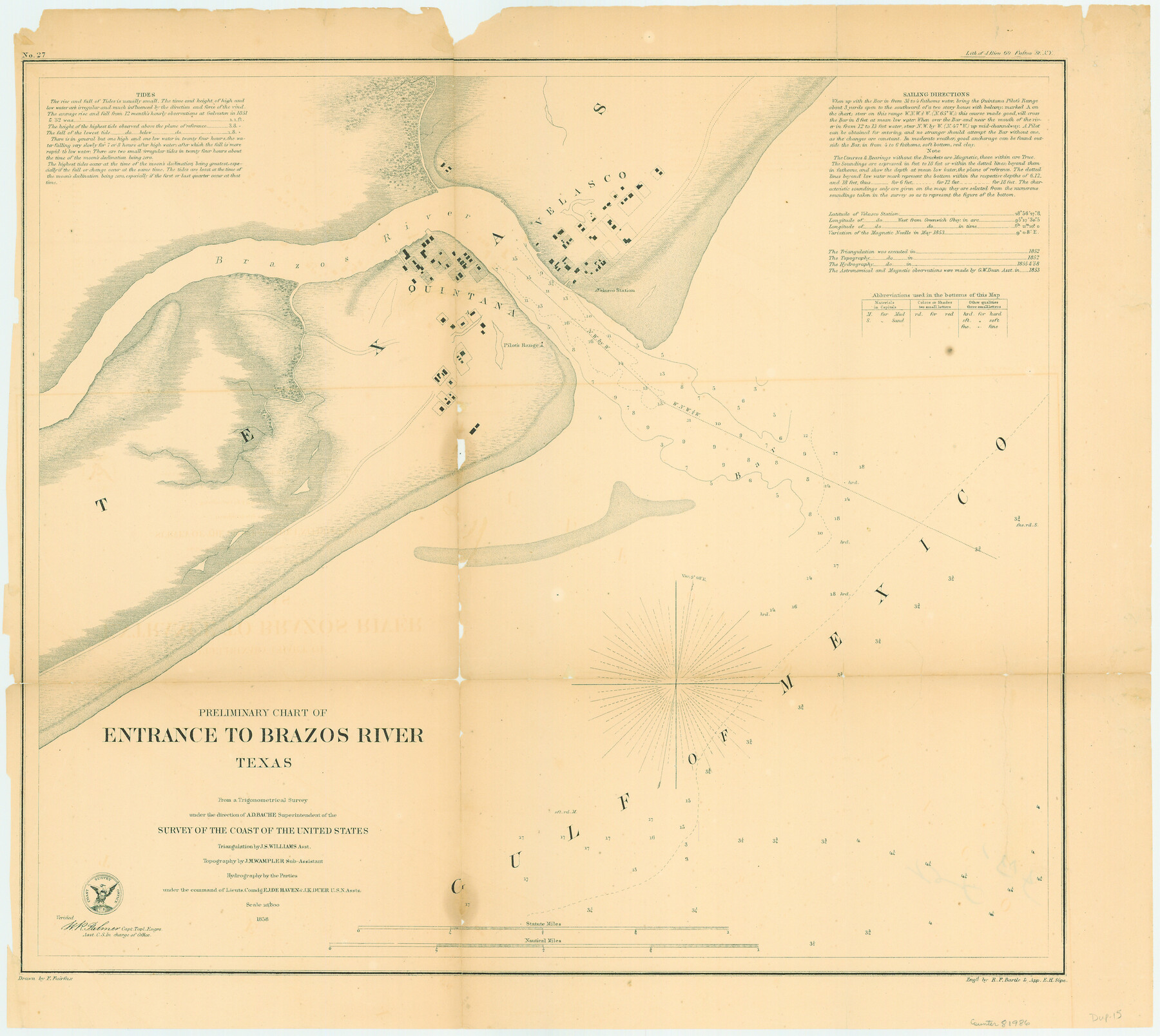
Preliminary Chart of Entrance to Brazos River, Texas
-
Map/Doc
81986
-
Collection
General Map Collection
-
Subjects
Nautical Charts
-
Height x Width
17.6 x 19.8 inches
44.7 x 50.3 cm
-
Comments
Conservation funded by Friends of the Texas General Land Office in 2004.
Part of: General Map Collection
Howard County Rolled Sketch 11

Print $20.00
- Digital $50.00
Howard County Rolled Sketch 11
1940
Size 21.4 x 30.1 inches
Map/Doc 6242
Trinity River, Rockwall Sheet/East Fork of Trinity River

Print $4.00
- Digital $50.00
Trinity River, Rockwall Sheet/East Fork of Trinity River
1936
Size 29.6 x 22.9 inches
Map/Doc 65193
Brewster County Working Sketch 36

Print $20.00
- Digital $50.00
Brewster County Working Sketch 36
1944
Size 22.7 x 42.3 inches
Map/Doc 67570
Flight Mission No. DAG-22K, Frame 76, Matagorda County

Print $20.00
- Digital $50.00
Flight Mission No. DAG-22K, Frame 76, Matagorda County
1953
Size 18.7 x 22.4 inches
Map/Doc 86463
Matagorda County Rolled Sketch 11

Print $40.00
- Digital $50.00
Matagorda County Rolled Sketch 11
Size 39.8 x 62.0 inches
Map/Doc 8348
Flight Mission No. DQO-1K, Frame 156, Galveston County

Print $20.00
- Digital $50.00
Flight Mission No. DQO-1K, Frame 156, Galveston County
1952
Size 18.8 x 22.4 inches
Map/Doc 85009
Right of Way Map, Belton Branch of the M.K.&T. RR.

Print $20.00
- Digital $50.00
Right of Way Map, Belton Branch of the M.K.&T. RR.
1896
Size 14.5 x 42.1 inches
Map/Doc 64219
Flight Mission No. DIX-3P, Frame 169, Aransas County

Print $20.00
- Digital $50.00
Flight Mission No. DIX-3P, Frame 169, Aransas County
1956
Size 17.8 x 18.3 inches
Map/Doc 83775
Texas-Indian Territory Denison Quadrangle

Print $20.00
- Digital $50.00
Texas-Indian Territory Denison Quadrangle
1901
Size 20.1 x 16.7 inches
Map/Doc 75110
Reeves County Rolled Sketch 38

Print $20.00
- Digital $50.00
Reeves County Rolled Sketch 38
2018
Size 24.4 x 38.6 inches
Map/Doc 95385
Brewster County Rolled Sketch 24A

Print $20.00
- Digital $50.00
Brewster County Rolled Sketch 24A
1910
Size 19.8 x 26.1 inches
Map/Doc 5208
Cherokee County Boundary File 1

Print $34.00
- Digital $50.00
Cherokee County Boundary File 1
Size 14.2 x 8.7 inches
Map/Doc 51272
You may also like
Panola County Working Sketch 32

Print $20.00
- Digital $50.00
Panola County Working Sketch 32
1982
Map/Doc 71441
Boundary between State of Texas and State of Louisiana from the 32nd Parallel South into the Gulf of Mexico

Print $326.00
Boundary between State of Texas and State of Louisiana from the 32nd Parallel South into the Gulf of Mexico
1977
Size 11.1 x 8.0 inches
Map/Doc 7710
Parker County Working Sketch 12

Print $20.00
- Digital $50.00
Parker County Working Sketch 12
1974
Map/Doc 71462
Dallam County Boundary File 4

Print $80.00
- Digital $50.00
Dallam County Boundary File 4
Size 9.4 x 49.8 inches
Map/Doc 52082
Winkler County Rolled Sketch 18

Print $20.00
- Digital $50.00
Winkler County Rolled Sketch 18
2017
Size 37.4 x 29.4 inches
Map/Doc 95289
Montgomery County Working Sketch 50

Print $20.00
- Digital $50.00
Montgomery County Working Sketch 50
1959
Size 25.3 x 21.9 inches
Map/Doc 71157
Shelby County Rolled Sketch 6

Print $20.00
- Digital $50.00
Shelby County Rolled Sketch 6
Size 26.7 x 20.9 inches
Map/Doc 7776
Chart of the Harbour of San [Luis]
![72762, Chart of the Harbour of San [Luis], General Map Collection](https://historictexasmaps.com/wmedia_w700/maps/72762.tif.jpg)
Print $20.00
- Digital $50.00
Chart of the Harbour of San [Luis]
1846
Size 27.2 x 18.2 inches
Map/Doc 72762
Working Sketch in Lynn County

Print $20.00
- Digital $50.00
Working Sketch in Lynn County
1921
Size 15.1 x 18.9 inches
Map/Doc 91343
El Paso County Working Sketch 35

Print $20.00
- Digital $50.00
El Paso County Working Sketch 35
1977
Size 19.8 x 30.3 inches
Map/Doc 69057
Flight Mission No. DAG-21K, Frame 101, Matagorda County

Print $20.00
- Digital $50.00
Flight Mission No. DAG-21K, Frame 101, Matagorda County
1952
Size 18.6 x 22.4 inches
Map/Doc 86430
[PSL Block B-19]
![93127, [PSL Block B-19], Twichell Survey Records](https://historictexasmaps.com/wmedia_w700/maps/93127-1.tif.jpg)
Print $40.00
- Digital $50.00
[PSL Block B-19]
Size 49.1 x 45.5 inches
Map/Doc 93127