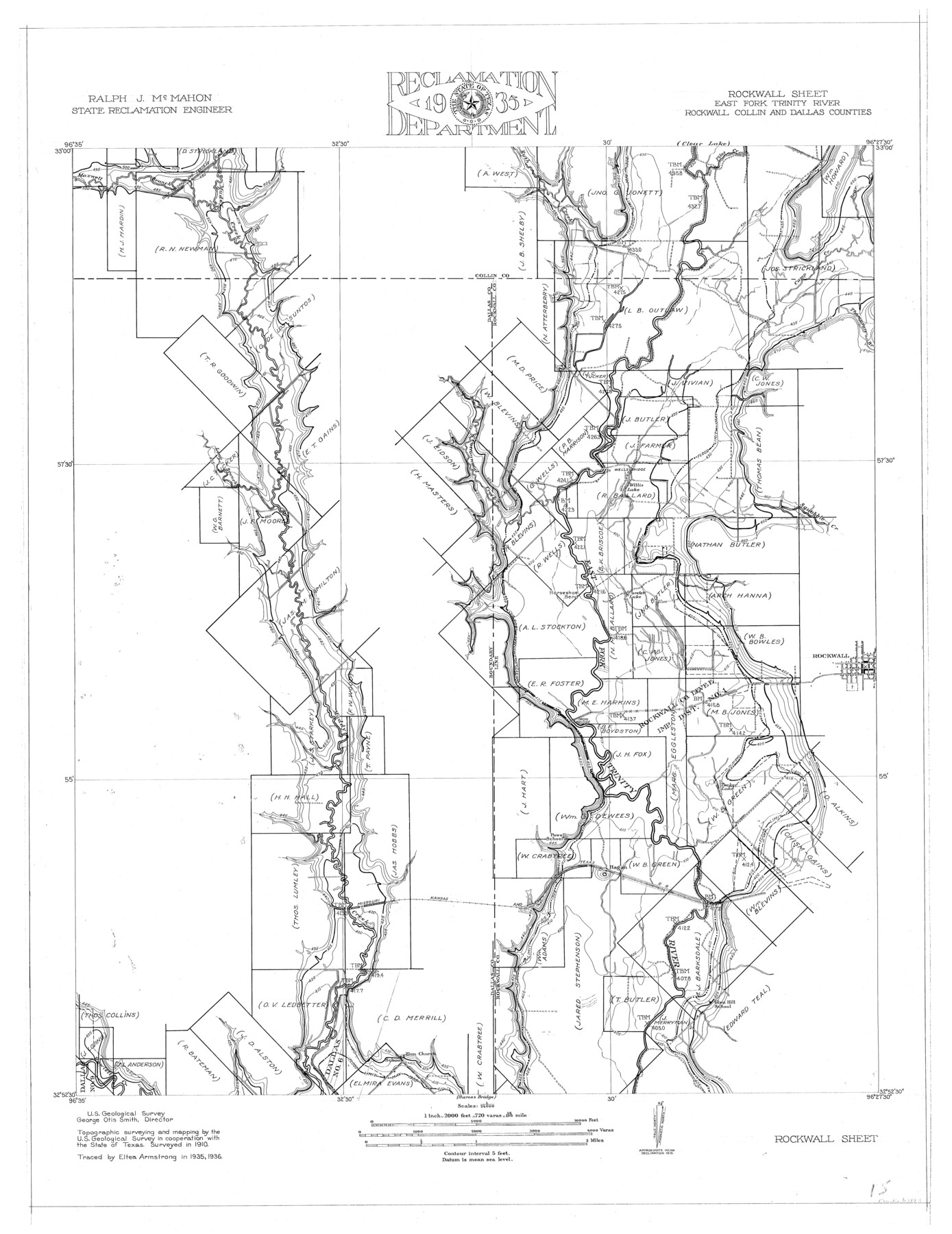
Trinity River, Rockwall Sheet/East Fork of Trinity River
-
Map/Doc
65193
-
Collection
General Map Collection
-
Object Dates
1936 (Creation Date)
-
People and Organizations
Texas State Reclamation Department (Publisher)
Eltea Armstrong (Draftsman)
-
Counties
Rockwall Collin Dallas
-
Subjects
River Surveys Topographic
-
Height x Width
29.6 x 22.9 inches
75.2 x 58.2 cm
-
Comments
Rockwall Sheet located south of the Clear Lake Sheet and north of the Barnes Sheet.
Part of: General Map Collection
Schleicher County Sketch File 35

Print $20.00
- Digital $50.00
Schleicher County Sketch File 35
1951
Size 13.8 x 19.4 inches
Map/Doc 12308
La Salle County Rolled Sketch 15

Print $20.00
- Digital $50.00
La Salle County Rolled Sketch 15
Size 22.0 x 32.4 inches
Map/Doc 6579
Flight Mission No. DQO-2K, Frame 147, Galveston County

Print $20.00
- Digital $50.00
Flight Mission No. DQO-2K, Frame 147, Galveston County
1952
Size 18.8 x 22.6 inches
Map/Doc 85044
Aransas County Sketch File 7

Print $4.00
- Digital $50.00
Aransas County Sketch File 7
Size 12.7 x 7.9 inches
Map/Doc 13112
[Surveys along Lagarta Creek]
![190, [Surveys along Lagarta Creek], General Map Collection](https://historictexasmaps.com/wmedia_w700/maps/190.tif.jpg)
Print $3.00
- Digital $50.00
[Surveys along Lagarta Creek]
1847
Size 10.7 x 15.1 inches
Map/Doc 190
Flight Mission No. BRA-8M, Frame 135, Jefferson County

Print $20.00
- Digital $50.00
Flight Mission No. BRA-8M, Frame 135, Jefferson County
1953
Size 18.7 x 22.3 inches
Map/Doc 85631
Red River County

Print $40.00
- Digital $50.00
Red River County
1934
Size 52.0 x 41.3 inches
Map/Doc 66995
Hutchinson County Working Sketch 44

Print $20.00
- Digital $50.00
Hutchinson County Working Sketch 44
1978
Size 27.6 x 23.4 inches
Map/Doc 66404
Flight Mission No. BRA-8M, Frame 134, Jefferson County

Print $20.00
- Digital $50.00
Flight Mission No. BRA-8M, Frame 134, Jefferson County
1953
Size 18.6 x 22.5 inches
Map/Doc 85630
Jeff Davis Co.

Print $40.00
- Digital $50.00
Jeff Davis Co.
1915
Size 26.7 x 49.4 inches
Map/Doc 3720
Tarrant County Sketch File 4

Print $4.00
- Digital $50.00
Tarrant County Sketch File 4
1856
Size 11.8 x 8.9 inches
Map/Doc 37678
Baylor County Sketch File 19

Print $4.00
- Digital $50.00
Baylor County Sketch File 19
1885
Size 11.5 x 8.8 inches
Map/Doc 14193
You may also like
Llano County Sketch File 14

Print $22.00
- Digital $50.00
Llano County Sketch File 14
Size 8.0 x 12.7 inches
Map/Doc 30389
Hopkins County Working Sketch Graphic Index

Print $20.00
- Digital $50.00
Hopkins County Working Sketch Graphic Index
1942
Size 40.6 x 38.7 inches
Map/Doc 76581
Tom Green County Sketch File 14

Print $20.00
- Digital $50.00
Tom Green County Sketch File 14
Size 34.8 x 45.7 inches
Map/Doc 10401
Sulphur River, Dunbar Creek Sheet

Print $4.00
- Digital $50.00
Sulphur River, Dunbar Creek Sheet
1941
Size 17.2 x 20.9 inches
Map/Doc 65174
Sterling County Rolled Sketch 20

Print $20.00
- Digital $50.00
Sterling County Rolled Sketch 20
Size 30.5 x 34.5 inches
Map/Doc 9952
Flight Mission No. DAG-18K, Frame 72, Matagorda County

Print $20.00
- Digital $50.00
Flight Mission No. DAG-18K, Frame 72, Matagorda County
1952
Size 18.5 x 22.2 inches
Map/Doc 86365
Mitchell County Working Sketch 8

Print $20.00
- Digital $50.00
Mitchell County Working Sketch 8
1975
Size 31.9 x 26.3 inches
Map/Doc 71065
[Lgs. 192-195, 176-179]
![90254, [Lgs. 192-195, 176-179], Twichell Survey Records](https://historictexasmaps.com/wmedia_w700/maps/90254-1.tif.jpg)
Print $20.00
- Digital $50.00
[Lgs. 192-195, 176-179]
Size 18.2 x 25.2 inches
Map/Doc 90254
Morris County Rolled Sketch 2A

Print $20.00
- Digital $50.00
Morris County Rolled Sketch 2A
Size 24.0 x 18.9 inches
Map/Doc 10244
Map of the City of Barry, John McGowan & J.B. & A. Adams Surveys, Navarro County, Texas

Print $20.00
- Digital $50.00
Map of the City of Barry, John McGowan & J.B. & A. Adams Surveys, Navarro County, Texas
1958
Size 28.4 x 25.4 inches
Map/Doc 94015

Map of the territory comprised between the Province of New Mexico and the fort of Natchitoches and Texas

Map of the territory comprised between the Province of New Mexico and the fort of Natchitoches and Texas
1789
Size 8.9 x 15.3 inches
Map/Doc 88888