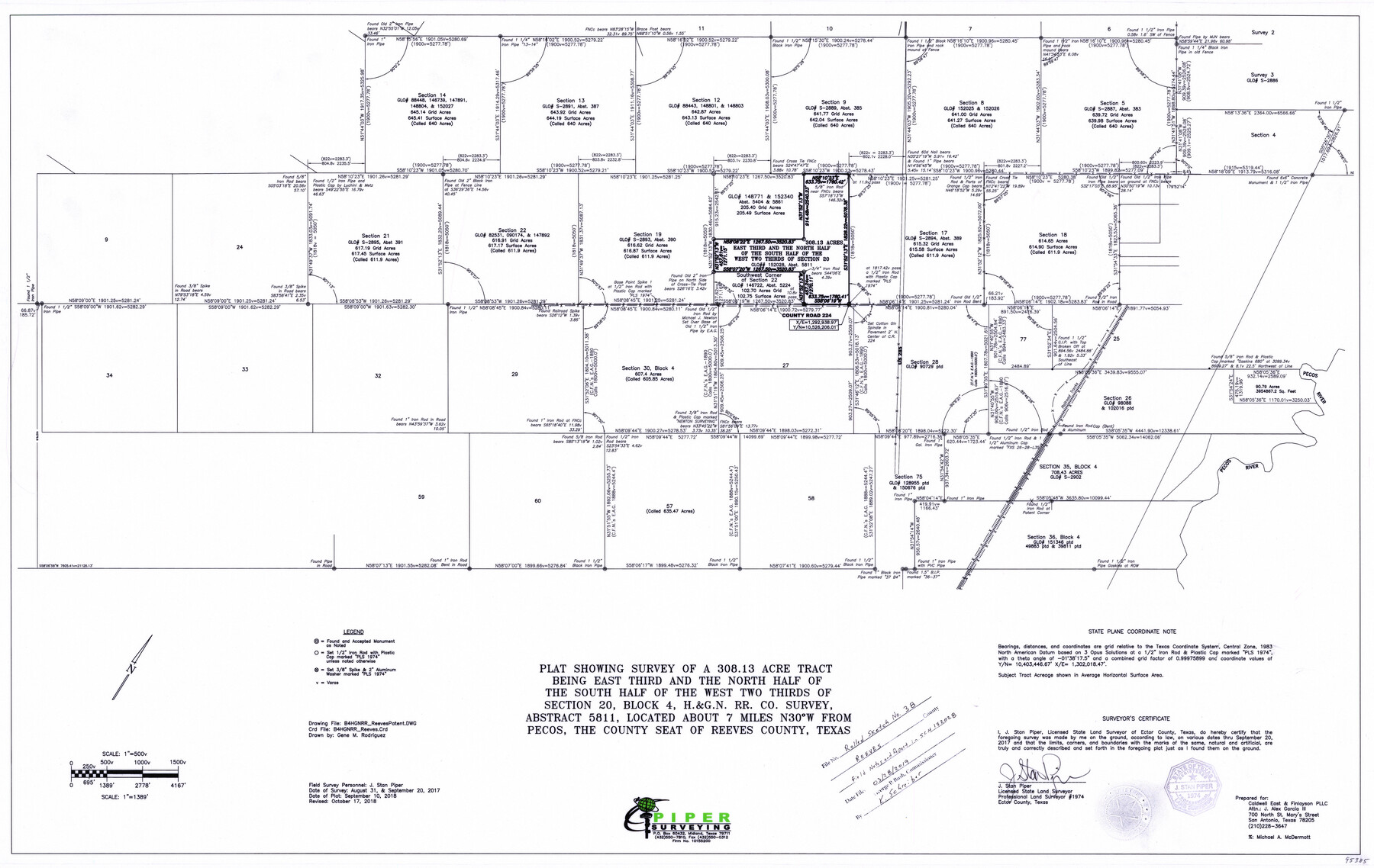
Reeves County Rolled Sketch 38
Plat showing survey of a 308.13 acre tract being east third and the north half of the south half of the west two thirds of section 20, Block 4, H. & G. N. R.R. Co. survey, abstract 5811
-
Map/Doc
95385
-
Collection
General Map Collection
-
Object Dates
2017/8/31 (Survey Date)
2017/9/20 (Survey Date)
2018/9/10 (Creation Date)
2018/10/17 (Revision Date)
2019/3/28 (File Date)
-
People and Organizations
J. Stan Piper (Surveyor/Engineer)
-
Counties
Reeves
-
Subjects
Surveying Rolled Sketch
-
Height x Width
24.4 x 38.6 inches
62.0 x 98.0 cm
-
Medium
mylar, print
-
Scale
1" = 500 varas
-
Comments
Field notes and report in School File 152028
Part of: General Map Collection
Coryell County Working Sketch 4

Print $20.00
- Digital $50.00
Coryell County Working Sketch 4
1929
Size 23.8 x 18.3 inches
Map/Doc 68211
Ward County Sketch File 12

Print $4.00
- Digital $50.00
Ward County Sketch File 12
Size 14.3 x 8.8 inches
Map/Doc 39638
Ellis County Sketch File 11

Print $40.00
- Digital $50.00
Ellis County Sketch File 11
1860
Size 12.6 x 16.2 inches
Map/Doc 21847
Dimmit County Working Sketch 32

Print $20.00
- Digital $50.00
Dimmit County Working Sketch 32
1959
Size 29.2 x 23.3 inches
Map/Doc 68693
Calhoun County NRC Article 33.136 Sketch 3

Print $40.00
- Digital $50.00
Calhoun County NRC Article 33.136 Sketch 3
2000
Size 24.4 x 36.5 inches
Map/Doc 81914
Township No. 4 South Range No. 19 West of the Indian Meridian

Print $20.00
- Digital $50.00
Township No. 4 South Range No. 19 West of the Indian Meridian
1875
Size 19.1 x 24.5 inches
Map/Doc 75183
Hunt County Sketch File 21

Print $4.00
- Digital $50.00
Hunt County Sketch File 21
Size 8.1 x 5.8 inches
Map/Doc 27122
Kimble County Sketch File 2

Print $2.00
- Digital $50.00
Kimble County Sketch File 2
Size 7.0 x 6.7 inches
Map/Doc 28909
Old Miscellaneous File 24

Print $6.00
- Digital $50.00
Old Miscellaneous File 24
1919
Size 14.4 x 8.7 inches
Map/Doc 75629
Oldham County Rolled Sketch 10

Print $20.00
- Digital $50.00
Oldham County Rolled Sketch 10
Size 22.0 x 13.3 inches
Map/Doc 7176
[Texas Gulf Coast from Rio Grande to Sabine Lake]
![72687, [Texas Gulf Coast from Rio Grande to Sabine Lake], General Map Collection](https://historictexasmaps.com/wmedia_w700/maps/72687.tif.jpg)
Print $20.00
- Digital $50.00
[Texas Gulf Coast from Rio Grande to Sabine Lake]
Size 28.1 x 18.3 inches
Map/Doc 72687
Gulf of Mexico

Print $20.00
- Digital $50.00
Gulf of Mexico
1961
Size 36.6 x 43.3 inches
Map/Doc 73551
You may also like
Flight Mission No. DIX-8P, Frame 85, Aransas County

Print $20.00
- Digital $50.00
Flight Mission No. DIX-8P, Frame 85, Aransas County
1956
Size 18.4 x 19.0 inches
Map/Doc 83910
Tyler County Rolled Sketch 5

Print $20.00
- Digital $50.00
Tyler County Rolled Sketch 5
1954
Size 29.3 x 40.0 inches
Map/Doc 8057

Gillespie County

Print $40.00
- Digital $50.00
Gillespie County
1945
Size 39.7 x 48.4 inches
Map/Doc 73157
Coke County Sketch File 19

Print $20.00
- Digital $50.00
Coke County Sketch File 19
Size 18.5 x 25.0 inches
Map/Doc 11110
Polk County Working Sketch 27

Print $40.00
- Digital $50.00
Polk County Working Sketch 27
1960
Size 45.9 x 51.2 inches
Map/Doc 71643
Winkler County Working Sketch 18

Print $40.00
- Digital $50.00
Winkler County Working Sketch 18
1980
Size 33.7 x 49.9 inches
Map/Doc 72612
Tom Green County Sketch File 2

Print $4.00
- Digital $50.00
Tom Green County Sketch File 2
Size 9.6 x 7.6 inches
Map/Doc 38161
Travis County Working Sketch 45

Print $20.00
- Digital $50.00
Travis County Working Sketch 45
1975
Size 33.6 x 28.7 inches
Map/Doc 69429
Orange County NRC Article 33.136 Sketch 5

Print $62.00
- Digital $50.00
Orange County NRC Article 33.136 Sketch 5
2014
Size 26.1 x 22.7 inches
Map/Doc 94946
Liberty County Sketch File 23

Print $4.00
- Digital $50.00
Liberty County Sketch File 23
1859
Size 10.0 x 8.2 inches
Map/Doc 29934
Liberty County Rolled Sketch F

Print $20.00
- Digital $50.00
Liberty County Rolled Sketch F
Size 24.9 x 25.5 inches
Map/Doc 6621