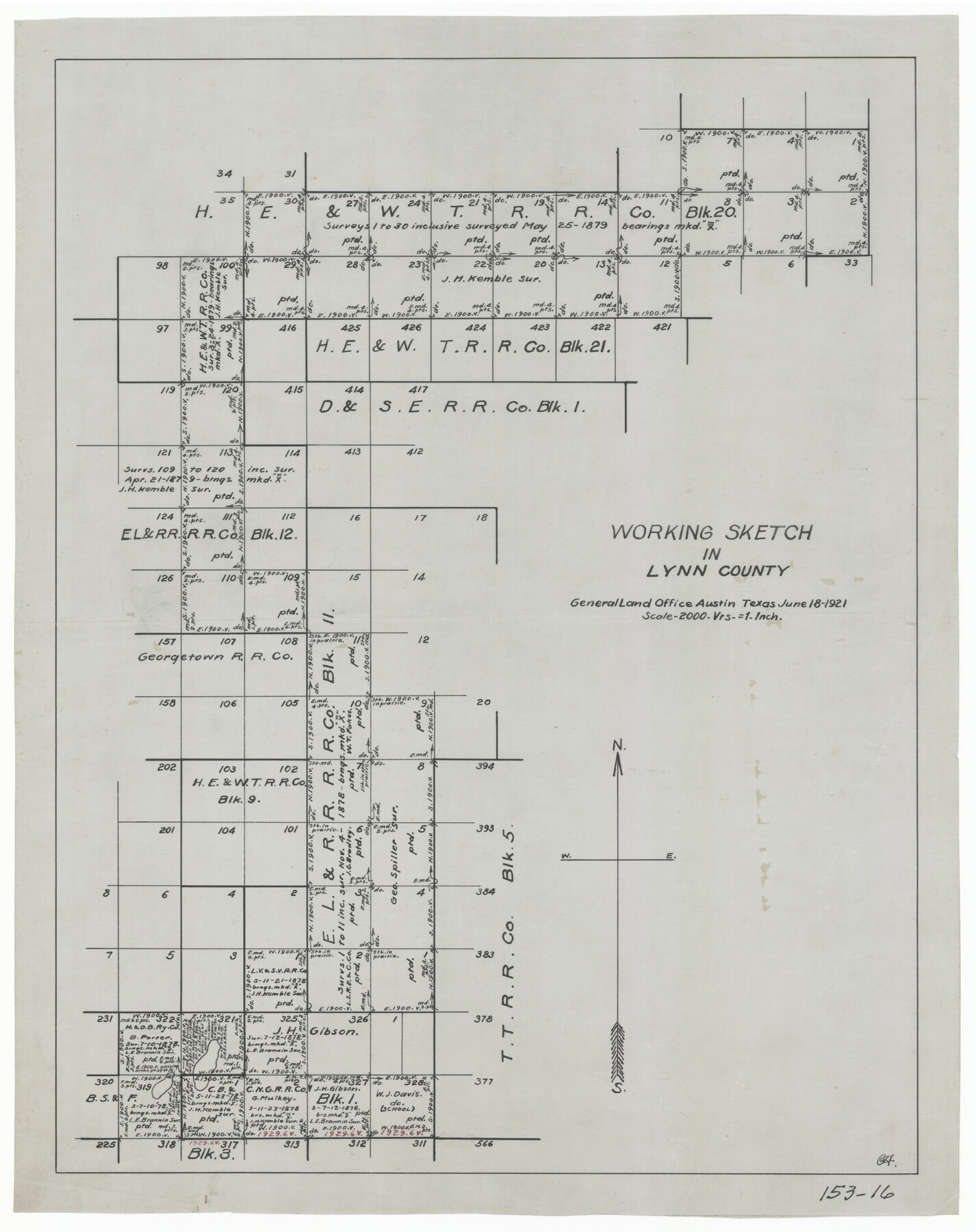
Working Sketch in Lynn County
153-16
-
Map/Doc
91343
-
Collection
Twichell Survey Records
-
Object Dates
6/18/1921 (Creation Date)
-
Counties
Lynn
-
Height x Width
15.1 x 18.9 inches
38.4 x 48.0 cm
Part of: Twichell Survey Records
[Blocks K3, K4, K7, K8, K14, M7, east part of Leagues]
![90592, [Blocks K3, K4, K7, K8, K14, M7, east part of Leagues], Twichell Survey Records](https://historictexasmaps.com/wmedia_w700/maps/90592-1.tif.jpg)
Print $20.00
- Digital $50.00
[Blocks K3, K4, K7, K8, K14, M7, east part of Leagues]
Size 33.4 x 31.8 inches
Map/Doc 90592
[Townships 1 through 5 North, Blocks 34, 35, and 36]
![92587, [Townships 1 through 5 North, Blocks 34, 35, and 36], Twichell Survey Records](https://historictexasmaps.com/wmedia_w700/maps/92587-1.tif.jpg)
Print $20.00
- Digital $50.00
[Townships 1 through 5 North, Blocks 34, 35, and 36]
Size 41.7 x 21.4 inches
Map/Doc 92587
[Area around J. E. Arnold survey]
![91885, [Area around J. E. Arnold survey], Twichell Survey Records](https://historictexasmaps.com/wmedia_w700/maps/91885-1.tif.jpg)
Print $2.00
- Digital $50.00
[Area around J. E. Arnold survey]
Size 15.3 x 8.2 inches
Map/Doc 91885
[Block 37, Townships 1 and 2 North]
![91344, [Block 37, Townships 1 and 2 North], Twichell Survey Records](https://historictexasmaps.com/wmedia_w700/maps/91344-1.tif.jpg)
Print $20.00
- Digital $50.00
[Block 37, Townships 1 and 2 North]
Size 13.9 x 34.3 inches
Map/Doc 91344
Pecos County Sketch showing location of oil wells within 1/2 mile radius of the south 8 acres of the Bob Reid survey

Print $20.00
- Digital $50.00
Pecos County Sketch showing location of oil wells within 1/2 mile radius of the south 8 acres of the Bob Reid survey
Size 18.4 x 16.5 inches
Map/Doc 91639
[Pencil sketch of C. B., H. L. and Jno. Robertson and surrounding surveys]
![89981, [Pencil sketch of C. B., H. L. and Jno. Robertson and surrounding surveys], Twichell Survey Records](https://historictexasmaps.com/wmedia_w700/maps/89981-1.tif.jpg)
Print $20.00
- Digital $50.00
[Pencil sketch of C. B., H. L. and Jno. Robertson and surrounding surveys]
Size 21.1 x 9.8 inches
Map/Doc 89981
Lubbock Irrigation Co. San Augustine County School Land Lubbock County, Texas

Print $20.00
- Digital $50.00
Lubbock Irrigation Co. San Augustine County School Land Lubbock County, Texas
Size 37.5 x 37.9 inches
Map/Doc 89894
[Area south of Runnels County School Land]
![93168, [Area south of Runnels County School Land], Twichell Survey Records](https://historictexasmaps.com/wmedia_w700/maps/93168-1.tif.jpg)
Print $40.00
- Digital $50.00
[Area south of Runnels County School Land]
Size 87.7 x 42.9 inches
Map/Doc 93168
Dawson County Sketch showing survey made in accordance with an order of the Hon. District Court of Garza County July Term A.D. 1917 in the case of F. M. Weaver vs. A. W. Higginbotham #41

Print $20.00
- Digital $50.00
Dawson County Sketch showing survey made in accordance with an order of the Hon. District Court of Garza County July Term A.D. 1917 in the case of F. M. Weaver vs. A. W. Higginbotham #41
1917
Size 23.1 x 18.1 inches
Map/Doc 90637
Working Sketch Crockett County

Print $20.00
- Digital $50.00
Working Sketch Crockett County
1925
Size 16.6 x 15.2 inches
Map/Doc 90476
[Blocks JD, B, D10, A2, A3]
![90777, [Blocks JD, B, D10, A2, A3], Twichell Survey Records](https://historictexasmaps.com/wmedia_w700/maps/90777-1.tif.jpg)
Print $2.00
- Digital $50.00
[Blocks JD, B, D10, A2, A3]
Size 7.3 x 13.4 inches
Map/Doc 90777
[George Gentry, Charles Welch, and Surrounding Surveys]
![91082, [George Gentry, Charles Welch, and Surrounding Surveys], Twichell Survey Records](https://historictexasmaps.com/wmedia_w700/maps/91082-1.tif.jpg)
Print $20.00
- Digital $50.00
[George Gentry, Charles Welch, and Surrounding Surveys]
1922
Size 28.6 x 32.0 inches
Map/Doc 91082
You may also like
Map of Leagues 245, 246, 247, 250, 251, 252, 253, 254, and 321, Surveys 128, 130, 131, 132, R. E. Montgomery, and Surveys 133 and 134, Block A, Public Free School Land

Print $20.00
- Digital $50.00
Map of Leagues 245, 246, 247, 250, 251, 252, 253, 254, and 321, Surveys 128, 130, 131, 132, R. E. Montgomery, and Surveys 133 and 134, Block A, Public Free School Land
1930
Size 21.8 x 29.4 inches
Map/Doc 91270
North and South Sulphur Rivers, Sulphur Bluff Sheet

Print $20.00
- Digital $50.00
North and South Sulphur Rivers, Sulphur Bluff Sheet
1933
Size 37.6 x 37.2 inches
Map/Doc 65163
Smith County Working Sketch 5

Print $20.00
- Digital $50.00
Smith County Working Sketch 5
1932
Size 32.2 x 22.4 inches
Map/Doc 63890
Milam County Working Sketch 11

Print $20.00
- Digital $50.00
Milam County Working Sketch 11
1987
Size 43.8 x 31.9 inches
Map/Doc 71026
Fisher County Rolled Sketch 4A

Print $20.00
- Digital $50.00
Fisher County Rolled Sketch 4A
1951
Size 31.0 x 36.6 inches
Map/Doc 8889
Map of Hays County Travis District

Print $20.00
- Digital $50.00
Map of Hays County Travis District
1861
Size 18.6 x 26.0 inches
Map/Doc 3648
Mills County Boundary File 3

Print $30.00
- Digital $50.00
Mills County Boundary File 3
Size 11.0 x 8.6 inches
Map/Doc 57281
Dimmit County Rolled Sketch 3

Print $20.00
- Digital $50.00
Dimmit County Rolled Sketch 3
Size 31.9 x 36.2 inches
Map/Doc 76142
[Surveys on Cibolo Creek]
![363, [Surveys on Cibolo Creek], General Map Collection](https://historictexasmaps.com/wmedia_w700/maps/363.tif.jpg)
Print $2.00
- Digital $50.00
[Surveys on Cibolo Creek]
Size 7.4 x 6.7 inches
Map/Doc 363
Flight Mission No. CRC-3R, Frame 104, Chambers County

Print $20.00
- Digital $50.00
Flight Mission No. CRC-3R, Frame 104, Chambers County
1956
Size 18.6 x 22.3 inches
Map/Doc 84842
Hidalgo County Sketch

Print $20.00
- Digital $50.00
Hidalgo County Sketch
1903
Size 30.4 x 37.7 inches
Map/Doc 4450
Jefferson County Working Sketch 32

Print $40.00
- Digital $50.00
Jefferson County Working Sketch 32
1981
Size 68.9 x 36.0 inches
Map/Doc 66576