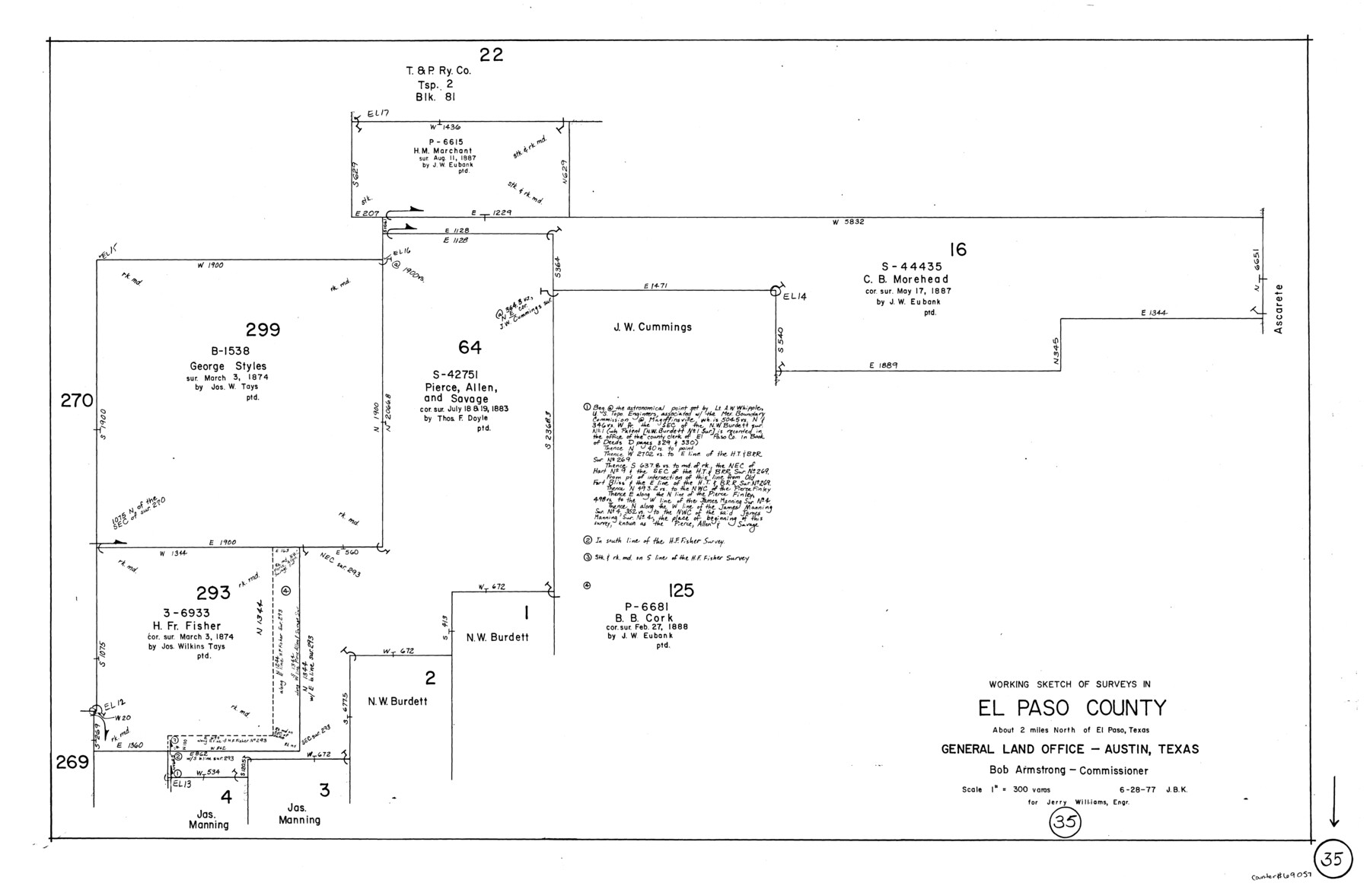
El Paso County Working Sketch 35
-
Map/Doc
69057
-
Collection
General Map Collection
-
Object Dates
6/28/1977 (Creation Date)
-
People and Organizations
Joan Kilpatrick (Draftsman)
-
Counties
El Paso
-
Subjects
Surveying Working Sketch
-
Height x Width
19.8 x 30.3 inches
50.3 x 77.0 cm
-
Scale
1" = 300 varas
Part of: General Map Collection
Uvalde County

Print $20.00
- Digital $50.00
Uvalde County
1976
Size 42.7 x 46.4 inches
Map/Doc 73310
Flight Mission No. DQN-1K, Frame 48, Calhoun County

Print $20.00
- Digital $50.00
Flight Mission No. DQN-1K, Frame 48, Calhoun County
1953
Size 17.3 x 18.6 inches
Map/Doc 84148
Calhoun County Rolled Sketch 35

Print $20.00
- Digital $50.00
Calhoun County Rolled Sketch 35
1929
Size 36.2 x 25.6 inches
Map/Doc 5378
PSL Field Notes for Block CS in Dallam County

PSL Field Notes for Block CS in Dallam County
Map/Doc 81649
Galveston County NRC Article 33.136 Sketch 42

Print $26.00
- Digital $50.00
Galveston County NRC Article 33.136 Sketch 42
2006
Size 22.1 x 33.7 inches
Map/Doc 83070
Smith County Working Sketch 17

Print $20.00
- Digital $50.00
Smith County Working Sketch 17
1994
Size 24.6 x 24.2 inches
Map/Doc 63902
Flight Mission No. DQO-2K, Frame 143, Galveston County

Print $20.00
- Digital $50.00
Flight Mission No. DQO-2K, Frame 143, Galveston County
1952
Size 18.8 x 22.5 inches
Map/Doc 85040
Presidio County Rolled Sketch T-1

Print $20.00
- Digital $50.00
Presidio County Rolled Sketch T-1
Size 26.8 x 27.1 inches
Map/Doc 7416

Stonewall County Rolled Sketch 18

Print $20.00
- Digital $50.00
Stonewall County Rolled Sketch 18
1950
Size 27.4 x 29.4 inches
Map/Doc 7872
Denton County Sketch File 20

Print $4.00
- Digital $50.00
Denton County Sketch File 20
1858
Size 8.5 x 10.3 inches
Map/Doc 20738
Zavala County

Print $20.00
- Digital $50.00
Zavala County
1977
Size 36.6 x 41.6 inches
Map/Doc 77468
You may also like
Angelina County Working Sketch 27

Print $40.00
- Digital $50.00
Angelina County Working Sketch 27
1954
Size 31.0 x 56.6 inches
Map/Doc 67109
Lubbock County Boundary File 1a

Print $20.00
- Digital $50.00
Lubbock County Boundary File 1a
Size 24.8 x 24.4 inches
Map/Doc 56487
Presidio County Sketch File P1

Print $4.00
- Digital $50.00
Presidio County Sketch File P1
Size 11.2 x 8.8 inches
Map/Doc 34556
Presidio County Sketch File 122

Print $22.00
- Digital $50.00
Presidio County Sketch File 122
2010
Size 11.0 x 8.5 inches
Map/Doc 89604
Flight Mission No. DCL-4C, Frame 6, Kenedy County

Print $20.00
- Digital $50.00
Flight Mission No. DCL-4C, Frame 6, Kenedy County
1943
Size 18.6 x 22.2 inches
Map/Doc 85807
Orange County Working Sketch 8

Print $20.00
- Digital $50.00
Orange County Working Sketch 8
1922
Size 20.7 x 24.3 inches
Map/Doc 71340

Flight Mission No. BRE-1P, Frame 71, Nueces County

Print $20.00
- Digital $50.00
Flight Mission No. BRE-1P, Frame 71, Nueces County
1956
Size 18.6 x 22.2 inches
Map/Doc 86653
Flight Mission No. DQN-5K, Frame 50, Calhoun County

Print $20.00
- Digital $50.00
Flight Mission No. DQN-5K, Frame 50, Calhoun County
1953
Size 18.5 x 22.3 inches
Map/Doc 84395
[Sketch showing A. B. & M. Block 2 in Potter and Randall Counties]
![91822, [Sketch showing A. B. & M. Block 2 in Potter and Randall Counties], Twichell Survey Records](https://historictexasmaps.com/wmedia_w700/maps/91822-1.tif.jpg)
Print $20.00
- Digital $50.00
[Sketch showing A. B. & M. Block 2 in Potter and Randall Counties]
1916
Size 27.2 x 33.4 inches
Map/Doc 91822
Borden County Sketch File 10b

Print $40.00
- Digital $50.00
Borden County Sketch File 10b
Size 23.0 x 17.0 inches
Map/Doc 10936
Tarrant County Sketch File 6

Print $4.00
- Digital $50.00
Tarrant County Sketch File 6
1859
Size 6.8 x 8.3 inches
Map/Doc 37682