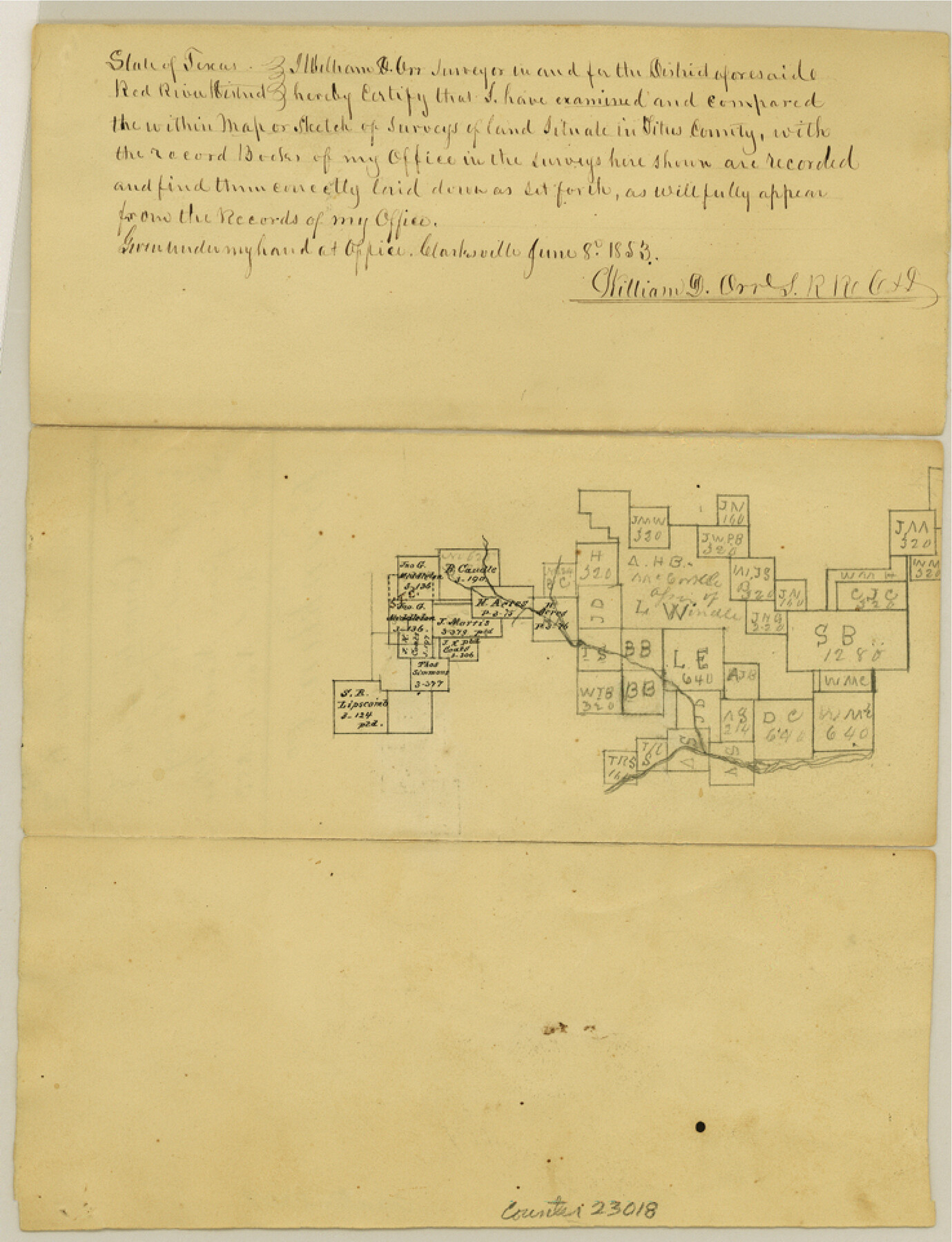
Franklin County Sketch File 6
[Sketch on the Cypress and north thereof, southwest from Mount Pleasant]
-
Map/Doc
23018
-
Collection
General Map Collection
-
Object Dates
1853/6/8 (Creation Date)
1853/11/1 (File Date)
-
People and Organizations
William D. Orr (Surveyor/Engineer)
-
Counties
Franklin Titus
-
Subjects
Surveying Sketch File
-
Height x Width
9.6 x 7.4 inches
24.4 x 18.8 cm
-
Medium
paper, manuscript
-
Features
[Cypress Creek]
Part of: General Map Collection
Jeff Davis County Rolled Sketch 28

Print $20.00
- Digital $50.00
Jeff Davis County Rolled Sketch 28
1977
Size 41.0 x 30.5 inches
Map/Doc 6376
Flight Mission No. CGI-1N, Frame 172, Cameron County

Print $20.00
- Digital $50.00
Flight Mission No. CGI-1N, Frame 172, Cameron County
1955
Size 18.5 x 22.2 inches
Map/Doc 84507
Midland County Rolled Sketch 1

Print $20.00
- Digital $50.00
Midland County Rolled Sketch 1
1940
Size 32.9 x 35.0 inches
Map/Doc 9512
Montgomery County Working Sketch 10

Print $20.00
- Digital $50.00
Montgomery County Working Sketch 10
1933
Size 36.5 x 38.6 inches
Map/Doc 71117
Live Oak County Sketch File 18

Print $11.00
- Digital $50.00
Live Oak County Sketch File 18
1895
Size 10.5 x 17.0 inches
Map/Doc 30284
Nolan County Boundary File 2

Print $52.00
- Digital $50.00
Nolan County Boundary File 2
Size 8.7 x 8.1 inches
Map/Doc 57649
Orange County Boundary File 8

Print $4.00
- Digital $50.00
Orange County Boundary File 8
Size 11.9 x 7.6 inches
Map/Doc 57780
Gillespie County Sketch File 3a

Print $4.00
- Digital $50.00
Gillespie County Sketch File 3a
1860
Size 7.6 x 8.3 inches
Map/Doc 24131
Flight Mission No. DAG-17K, Frame 123, Matagorda County

Print $20.00
- Digital $50.00
Flight Mission No. DAG-17K, Frame 123, Matagorda County
1952
Size 18.6 x 22.3 inches
Map/Doc 86343
Flight Mission No. CRE-1R, Frame 65, Jackson County

Print $20.00
- Digital $50.00
Flight Mission No. CRE-1R, Frame 65, Jackson County
1956
Size 18.6 x 22.3 inches
Map/Doc 85328
Flight Mission No. CRC-4R, Frame 111, Chambers County

Print $20.00
- Digital $50.00
Flight Mission No. CRC-4R, Frame 111, Chambers County
1956
Size 18.5 x 22.4 inches
Map/Doc 84908
A Map of Part of Matagorda Peninsula, State of Texas

Print $40.00
- Digital $50.00
A Map of Part of Matagorda Peninsula, State of Texas
1856
Size 34.4 x 54.2 inches
Map/Doc 69980
You may also like
Childress Co.

Print $20.00
- Digital $50.00
Childress Co.
1892
Size 40.3 x 33.7 inches
Map/Doc 66752
Flight Mission No. BRA-9M, Frame 78, Jefferson County

Print $20.00
- Digital $50.00
Flight Mission No. BRA-9M, Frame 78, Jefferson County
1953
Size 18.5 x 22.5 inches
Map/Doc 85661
United States Including California, Texas, and c.

Print $20.00
United States Including California, Texas, and c.
1861
Size 21.4 x 25.7 inches
Map/Doc 76238
Sutton County Working Sketch 31

Print $20.00
- Digital $50.00
Sutton County Working Sketch 31
1929
Size 19.2 x 21.8 inches
Map/Doc 62374
Webb County Rolled Sketch 31

Print $20.00
- Digital $50.00
Webb County Rolled Sketch 31
Size 38.8 x 44.5 inches
Map/Doc 10122
Terrell County Working Sketch 58

Print $40.00
- Digital $50.00
Terrell County Working Sketch 58
1960
Size 36.3 x 48.9 inches
Map/Doc 69579
Lamb County Sketch File 11

Print $6.00
- Digital $50.00
Lamb County Sketch File 11
1913
Size 11.5 x 8.8 inches
Map/Doc 29360
Floyd County Boundary File 2a

Print $40.00
- Digital $50.00
Floyd County Boundary File 2a
Size 19.8 x 39.2 inches
Map/Doc 53488
L'Amerique Meridionale, et Septentrionale Dressee selon les derniers Relations et suivant les Nouvelles Decouvertes

Print $20.00
- Digital $50.00
L'Amerique Meridionale, et Septentrionale Dressee selon les derniers Relations et suivant les Nouvelles Decouvertes
1726
Size 18.9 x 24.1 inches
Map/Doc 95134
Grimes County Working Sketch 2

Print $20.00
- Digital $50.00
Grimes County Working Sketch 2
1941
Size 13.2 x 20.9 inches
Map/Doc 63293
Val Verde County Working Sketch 13

Print $20.00
- Digital $50.00
Val Verde County Working Sketch 13
1922
Size 24.8 x 25.3 inches
Map/Doc 72148
Matagorda County Rolled Sketch 11

Print $40.00
- Digital $50.00
Matagorda County Rolled Sketch 11
Size 39.8 x 62.0 inches
Map/Doc 8348