![81921, Map of the State of Texas [West Part], General Map Collection](https://historictexasmaps.com/wmedia_w1800h1800/maps/81921.tif.jpg)
Map of the State of Texas [West Part]
[West Part of] Map of the State of Texas
K-4-33b
-
Map/Doc
81921
-
Collection
General Map Collection
-
Object Dates
1938 (Creation Date)
-
People and Organizations
Railroad Commission (Publisher)
Engineering Department (Compiler)
-
Subjects
State of Texas
-
Height x Width
68.7 x 38.2 inches
174.5 x 97.0 cm
-
Comments
Map is in two pieces. For the east part see map number 81920.
Part of: General Map Collection
La Salle County Sketch File 45

Print $40.00
- Digital $50.00
La Salle County Sketch File 45
1939
Size 16.9 x 14.2 inches
Map/Doc 29601
Webb County Rolled Sketch 39

Print $20.00
- Digital $50.00
Webb County Rolled Sketch 39
1941
Size 21.3 x 18.4 inches
Map/Doc 8194
Andrews County Rolled Sketch 46

Print $40.00
- Digital $50.00
Andrews County Rolled Sketch 46
2013
Size 52.0 x 36.0 inches
Map/Doc 93641
Flight Mission No. CRC-2R, Frame 132, Chambers County

Print $20.00
- Digital $50.00
Flight Mission No. CRC-2R, Frame 132, Chambers County
1956
Size 18.6 x 22.3 inches
Map/Doc 84748

Young County Sketch File 6

Print $14.00
- Digital $50.00
Young County Sketch File 6
Size 13.0 x 8.2 inches
Map/Doc 40852
Harris County Working Sketch 29

Print $20.00
- Digital $50.00
Harris County Working Sketch 29
1934
Size 22.6 x 30.5 inches
Map/Doc 65921
Galveston County Sketch File 5a

Print $4.00
- Digital $50.00
Galveston County Sketch File 5a
1847
Size 12.6 x 8.2 inches
Map/Doc 23360
Kendall County Sketch File 23

Print $40.00
- Digital $50.00
Kendall County Sketch File 23
1938
Size 15.5 x 15.9 inches
Map/Doc 28716
Palo Pinto County Rolled Sketch 10

Print $20.00
- Digital $50.00
Palo Pinto County Rolled Sketch 10
1954
Size 35.4 x 34.1 inches
Map/Doc 9676
Polk County Sketch File 39

Print $24.00
- Digital $50.00
Polk County Sketch File 39
Size 8.3 x 13.3 inches
Map/Doc 34278
Shelby County Rolled Sketch 6

Print $20.00
- Digital $50.00
Shelby County Rolled Sketch 6
Size 26.7 x 20.9 inches
Map/Doc 7776
You may also like

Map of Tom Green County

Print $40.00
- Digital $50.00
Map of Tom Green County
1892
Size 43.2 x 48.3 inches
Map/Doc 63070
Hardin County Sketch File 31

Print $2.00
- Digital $50.00
Hardin County Sketch File 31
Size 8.5 x 7.1 inches
Map/Doc 25162
Coleman County Working Sketch 2
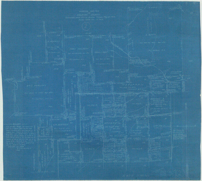
Print $20.00
- Digital $50.00
Coleman County Working Sketch 2
1917
Size 15.0 x 16.8 inches
Map/Doc 68068
Van Zandt County

Print $20.00
- Digital $50.00
Van Zandt County
1870
Size 22.9 x 21.6 inches
Map/Doc 4112
Map of Texas and Parts of Adjoining Territories

Print $20.00
Map of Texas and Parts of Adjoining Territories
1899
Size 33.7 x 36.0 inches
Map/Doc 79304
Terrell County Working Sketch 59

Print $20.00
- Digital $50.00
Terrell County Working Sketch 59
1961
Size 20.3 x 21.8 inches
Map/Doc 69580
Lubbock County Sketch

Print $20.00
- Digital $50.00
Lubbock County Sketch
1945
Size 19.0 x 29.8 inches
Map/Doc 92797
Flight Mission No. CRE-1R, Frame 65, Jackson County

Print $20.00
- Digital $50.00
Flight Mission No. CRE-1R, Frame 65, Jackson County
1956
Size 18.6 x 22.3 inches
Map/Doc 85328
Glasscock County Sketch File 12

Print $5.00
- Digital $50.00
Glasscock County Sketch File 12
1935
Size 14.1 x 9.2 inches
Map/Doc 24176
Archer County Working Sketch 1a

Print $20.00
- Digital $50.00
Archer County Working Sketch 1a
Size 42.8 x 42.5 inches
Map/Doc 83096
Lubbock County Boundary File 4

Print $4.00
- Digital $50.00
Lubbock County Boundary File 4
Size 11.2 x 8.8 inches
Map/Doc 56491