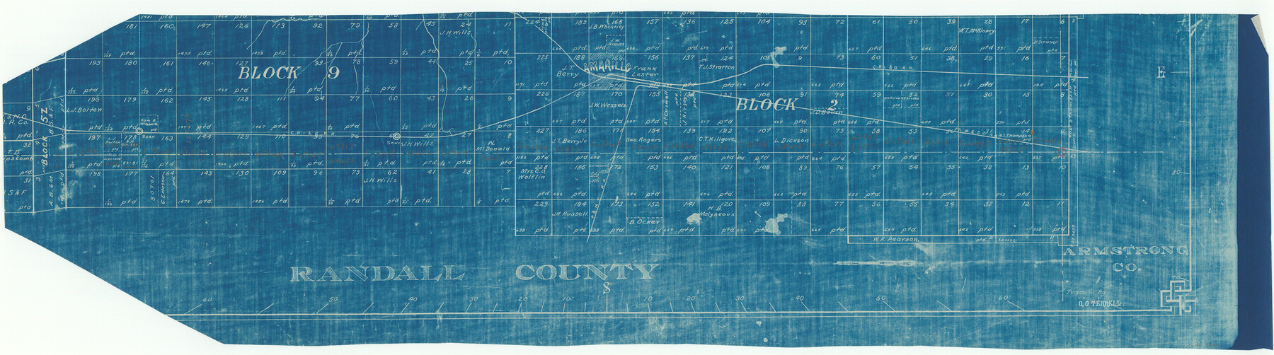
Potter County Boundary File 4b
-
Map/Doc
58012
-
Collection
General Map Collection
-
Counties
Potter
-
Subjects
County Boundaries
-
Height x Width
9.2 x 32.9 inches
23.4 x 83.6 cm
Part of: General Map Collection
Red River County Working Sketch 67

Print $20.00
- Digital $50.00
Red River County Working Sketch 67
1974
Size 46.9 x 37.7 inches
Map/Doc 72050
Gregg County Rolled Sketch 12

Print $40.00
- Digital $50.00
Gregg County Rolled Sketch 12
1939
Size 49.5 x 55.5 inches
Map/Doc 9065
Victoria County Aerial Photograph Index Sheet 4

Print $20.00
- Digital $50.00
Victoria County Aerial Photograph Index Sheet 4
1953
Size 19.8 x 23.4 inches
Map/Doc 83748
Maverick County Working Sketch 9

Print $20.00
- Digital $50.00
Maverick County Working Sketch 9
1959
Size 43.8 x 42.2 inches
Map/Doc 70901
Flight Mission No. DIX-5P, Frame 149, Aransas County

Print $20.00
- Digital $50.00
Flight Mission No. DIX-5P, Frame 149, Aransas County
1956
Size 17.8 x 17.8 inches
Map/Doc 83811
Kaufman County Sketch File 5

Print $22.00
- Digital $50.00
Kaufman County Sketch File 5
1849
Size 7.6 x 12.6 inches
Map/Doc 28632
Flight Mission No. BRE-2P, Frame 50, Nueces County

Print $20.00
- Digital $50.00
Flight Mission No. BRE-2P, Frame 50, Nueces County
1956
Size 18.5 x 22.4 inches
Map/Doc 86752
Deaf Smith County Sketch File C

Print $28.00
- Digital $50.00
Deaf Smith County Sketch File C
1902
Size 11.5 x 8.9 inches
Map/Doc 20639
Outer Continental Shelf Leasing Maps (Louisiana Offshore Operations)

Print $20.00
- Digital $50.00
Outer Continental Shelf Leasing Maps (Louisiana Offshore Operations)
1955
Size 19.8 x 12.0 inches
Map/Doc 75859
King County Boundary File 5

Print $12.00
- Digital $50.00
King County Boundary File 5
Size 14.2 x 8.8 inches
Map/Doc 64916
Red River County Working Sketch 19

Print $40.00
- Digital $50.00
Red River County Working Sketch 19
1955
Size 55.0 x 38.6 inches
Map/Doc 72002
Jeff Davis County Rolled Sketch 27

Print $20.00
- Digital $50.00
Jeff Davis County Rolled Sketch 27
1969
Size 29.3 x 36.8 inches
Map/Doc 6375
You may also like
Flight Mission No. CUG-2P, Frame 59, Kleberg County

Print $20.00
- Digital $50.00
Flight Mission No. CUG-2P, Frame 59, Kleberg County
1956
Size 18.4 x 22.1 inches
Map/Doc 86196
Brewster County Sketch File 21

Print $40.00
- Digital $50.00
Brewster County Sketch File 21
Size 23.1 x 18.9 inches
Map/Doc 10980
Refugio County Rolled Sketch 9

Print $20.00
- Digital $50.00
Refugio County Rolled Sketch 9
1955
Size 32.4 x 35.2 inches
Map/Doc 7509
Hydrographic Survey H-6396 of Outer Coast of Padre Island; Gulf of Mexico

Print $40.00
- Digital $50.00
Hydrographic Survey H-6396 of Outer Coast of Padre Island; Gulf of Mexico
1938
Size 55.4 x 34.0 inches
Map/Doc 2698
Hall County Sketch File 28

Print $20.00
- Digital $50.00
Hall County Sketch File 28
1913
Size 18.0 x 21.5 inches
Map/Doc 11611
Glasscock County

Print $20.00
- Digital $50.00
Glasscock County
1899
Size 44.2 x 35.5 inches
Map/Doc 4957
Montague County Working Sketch 12

Print $20.00
- Digital $50.00
Montague County Working Sketch 12
1937
Size 23.3 x 23.8 inches
Map/Doc 71078
Harrison County Working Sketch 25

Print $20.00
- Digital $50.00
Harrison County Working Sketch 25
1983
Size 21.9 x 24.0 inches
Map/Doc 66045
[Sketch showing sections 6, 7, 16, 32, 42 and 43]
![91775, [Sketch showing sections 6, 7, 16, 32, 42 and 43], Twichell Survey Records](https://historictexasmaps.com/wmedia_w700/maps/91775-1.tif.jpg)
Print $3.00
- Digital $50.00
[Sketch showing sections 6, 7, 16, 32, 42 and 43]
Size 14.5 x 11.2 inches
Map/Doc 91775
Cameron County Rolled Sketch 30

Print $20.00
- Digital $50.00
Cameron County Rolled Sketch 30
1930
Size 36.3 x 24.4 inches
Map/Doc 5394
[Worksheets related to the Wilson Strickland survey and vicinity]
![91267, [Vicinity and related to the Wilson Strickland Survey], Twichell Survey Records](https://historictexasmaps.com/wmedia_w700/maps/91267-1.tif.jpg)
Print $20.00
- Digital $50.00
[Worksheets related to the Wilson Strickland survey and vicinity]
Size 21.7 x 19.4 inches
Map/Doc 91267
Nueces County Rolled Sketch 50

Print $20.00
- Digital $50.00
Nueces County Rolled Sketch 50
1939
Size 21.9 x 38.0 inches
Map/Doc 9605