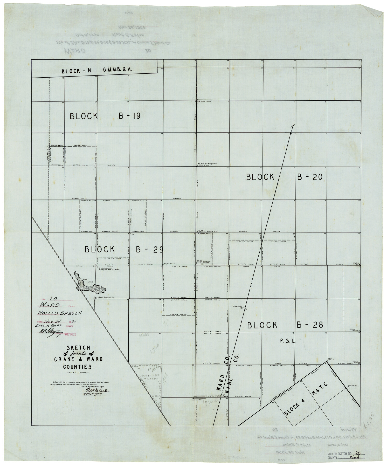
Ward County Rolled Sketch 20
Sketch of parts of Crane & Ward Counties [showing parts of PSL Blocks B-19, B-20, B-28, and B-29 and surrounding areas]
-
Map/Doc
8162
-
Collection
General Map Collection
-
Object Dates
1950/10/8 (Creation Date)
1950/11/24 (File Date)
-
People and Organizations
Robt. E. Estes (Surveyor/Engineer)
-
Counties
Ward Crane
-
Subjects
Surveying Rolled Sketch
-
Height x Width
27.4 x 22.7 inches
69.6 x 57.7 cm
-
Medium
linen, manuscript
-
Scale
1" = 1000 varas
Part of: General Map Collection
Randall County Sketch File 6

Print $20.00
- Digital $50.00
Randall County Sketch File 6
Size 17.2 x 23.5 inches
Map/Doc 12208
Hunt County Boundary File 1

Print $18.00
- Digital $50.00
Hunt County Boundary File 1
Size 8.2 x 3.4 inches
Map/Doc 55180
Gonzales County Boundary File 1b

Print $52.00
- Digital $50.00
Gonzales County Boundary File 1b
Size 8.0 x 5.0 inches
Map/Doc 53803
Somervell County Working Sketch 3

Print $20.00
- Digital $50.00
Somervell County Working Sketch 3
1968
Size 23.0 x 30.4 inches
Map/Doc 63907
![94184, Texas [Verso], General Map Collection](https://historictexasmaps.com/wmedia_w700/maps/94184.tif.jpg)
Travis County Appraisal District Plat Map 2_3013

Print $20.00
- Digital $50.00
Travis County Appraisal District Plat Map 2_3013
Size 21.5 x 26.4 inches
Map/Doc 94220
Map of Upshur County Showing Location T&P R.

Print $20.00
- Digital $50.00
Map of Upshur County Showing Location T&P R.
1872
Size 26.5 x 19.4 inches
Map/Doc 64137
Archer County Sketch File 26

Print $4.00
- Digital $50.00
Archer County Sketch File 26
1934
Size 9.7 x 4.4 inches
Map/Doc 13663
Hutchinson County Rolled Sketch 44-11

Print $20.00
- Digital $50.00
Hutchinson County Rolled Sketch 44-11
2002
Size 24.0 x 36.0 inches
Map/Doc 77547
Marion County Working Sketch 9

Print $20.00
- Digital $50.00
Marion County Working Sketch 9
1940
Size 23.5 x 25.5 inches
Map/Doc 70784
Panola County Working Sketch 38

Print $20.00
- Digital $50.00
Panola County Working Sketch 38
1991
Map/Doc 71447
Somervell County Working Sketch Graphic Index

Print $20.00
- Digital $50.00
Somervell County Working Sketch Graphic Index
1941
Size 27.0 x 25.7 inches
Map/Doc 76700
You may also like
Stephens County Working Sketch Graphic Index

Print $20.00
- Digital $50.00
Stephens County Working Sketch Graphic Index
1940
Size 41.1 x 39.4 inches
Map/Doc 76702
Midland County Boundary File 4b

Print $18.00
- Digital $50.00
Midland County Boundary File 4b
Size 13.6 x 9.0 inches
Map/Doc 57186
Right of Way & Track Map San Antonio & Aransas Pass Railway Co.

Print $40.00
- Digital $50.00
Right of Way & Track Map San Antonio & Aransas Pass Railway Co.
1919
Size 25.6 x 57.0 inches
Map/Doc 64025
Texas-Oklahoma, Red River, Big Bend Area

Print $40.00
- Digital $50.00
Texas-Oklahoma, Red River, Big Bend Area
1921
Size 23.3 x 57.6 inches
Map/Doc 75251
Culberson County Sketch File EM and RJ

Print $24.00
- Digital $50.00
Culberson County Sketch File EM and RJ
Size 13.3 x 8.8 inches
Map/Doc 20157
Rockwall County Boundary File 6

Print $48.00
- Digital $50.00
Rockwall County Boundary File 6
Size 14.0 x 8.6 inches
Map/Doc 58420
Lipscomb County Boundary File 14b

Print $60.00
- Digital $50.00
Lipscomb County Boundary File 14b
Size 7.3 x 8.7 inches
Map/Doc 56370
Jefferson County Rolled Sketch 57

Print $20.00
- Digital $50.00
Jefferson County Rolled Sketch 57
1883
Size 25.9 x 18.6 inches
Map/Doc 6407
Reagan County Rolled Sketch 17A

Print $20.00
- Digital $50.00
Reagan County Rolled Sketch 17A
1948
Size 33.8 x 32.4 inches
Map/Doc 9813
Hockley County Sketch File 2

Print $20.00
- Digital $50.00
Hockley County Sketch File 2
1900
Size 13.2 x 18.1 inches
Map/Doc 11768
Childress County Boundary File 2

Print $66.00
- Digital $50.00
Childress County Boundary File 2
Size 7.3 x 3.9 inches
Map/Doc 51306
General Highway Map, Crane County, Texas

Print $20.00
General Highway Map, Crane County, Texas
1940
Size 25.2 x 18.3 inches
Map/Doc 79061