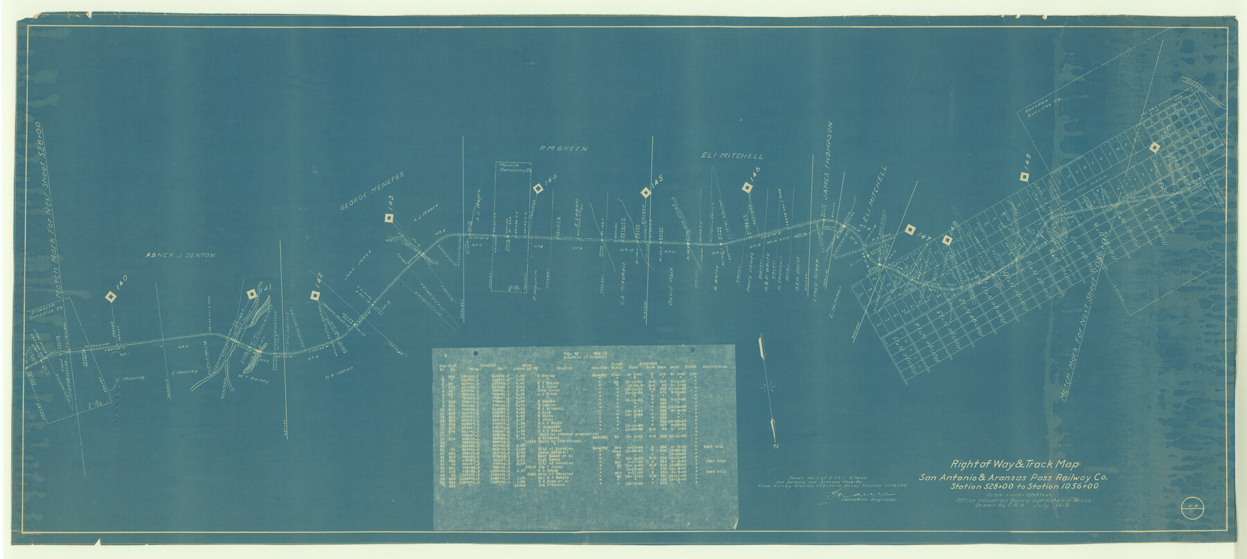
Right of Way & Track Map San Antonio & Aransas Pass Railway Co.
Station 528+00 to Station 1056+00
Z-2-5
-
Map/Doc
64025
-
Collection
General Map Collection
-
Object Dates
1919 (Creation Date)
-
People and Organizations
C.R.A. (Draftsman)
L. Adams (Surveyor/Engineer)
-
Counties
Caldwell Gonzales
-
Subjects
Railroads
-
Height x Width
25.6 x 57.0 inches
65.0 x 144.8 cm
-
Medium
blueprint/diazo
-
Scale
1" = 1000 feet
-
Comments
See counter nos. 64025 through 64027 for other sections of the map.
-
Features
SA&AP
[Rail line] to Yoakum
[Rail line] to Lockhart
Guadalupe River
Elm Slough
Mitchell Creek
Peach Creek
Part of: General Map Collection
Edwards County Sketch File 47

Print $24.00
- Digital $50.00
Edwards County Sketch File 47
1955
Size 11.4 x 8.9 inches
Map/Doc 21795
Nueces County Sketch File 28

Print $6.00
- Digital $50.00
Nueces County Sketch File 28
Size 10.0 x 10.9 inches
Map/Doc 32596
Lynn County Working Sketch 1

Print $20.00
- Digital $50.00
Lynn County Working Sketch 1
1945
Size 17.2 x 14.0 inches
Map/Doc 70671
Trinity County Sketch File 16

Print $4.00
- Digital $50.00
Trinity County Sketch File 16
1879
Size 8.2 x 11.1 inches
Map/Doc 38544
Robertson County Working Sketch 9

Print $20.00
- Digital $50.00
Robertson County Working Sketch 9
1984
Size 19.9 x 21.5 inches
Map/Doc 63582
Sutton County Sketch File 6a

Print $6.00
- Digital $50.00
Sutton County Sketch File 6a
1898
Size 7.5 x 6.4 inches
Map/Doc 37362

Crockett County Sketch File 94

Print $6.00
- Digital $50.00
Crockett County Sketch File 94
1940
Size 9.2 x 12.3 inches
Map/Doc 19950
[Sketch for Mineral Application 35811 - Liberty County, John Mecom]
![65619, [Sketch for Mineral Application 35811 - Liberty County, John Mecom], General Map Collection](https://historictexasmaps.com/wmedia_w700/maps/65619.tif.jpg)
Print $4.00
- Digital $50.00
[Sketch for Mineral Application 35811 - Liberty County, John Mecom]
1941
Size 24.9 x 20.0 inches
Map/Doc 65619
Reagan County Rolled Sketch 17

Print $20.00
- Digital $50.00
Reagan County Rolled Sketch 17
Size 33.9 x 32.6 inches
Map/Doc 10623
Presidio County Sketch File 43

Print $10.00
- Digital $50.00
Presidio County Sketch File 43
1913
Size 11.2 x 8.7 inches
Map/Doc 34520
Collingsworth County

Print $20.00
- Digital $50.00
Collingsworth County
1971
Size 42.5 x 36.2 inches
Map/Doc 73111
You may also like
Blanco County Working Sketch 7

Print $20.00
- Digital $50.00
Blanco County Working Sketch 7
1924
Size 12.9 x 12.1 inches
Map/Doc 67367
Baylor County Sketch File 11C

Print $20.00
- Digital $50.00
Baylor County Sketch File 11C
1892
Map/Doc 88491
McCulloch County Working Sketch 4

Print $20.00
- Digital $50.00
McCulloch County Working Sketch 4
1956
Size 25.3 x 22.8 inches
Map/Doc 70679
[H. & T. C. RR. Company, Block 47, Map C]
![91258, [H. & T. C. RR. Company, Block 47, Map C], Twichell Survey Records](https://historictexasmaps.com/wmedia_w700/maps/91258-1.tif.jpg)
Print $20.00
- Digital $50.00
[H. & T. C. RR. Company, Block 47, Map C]
Size 34.1 x 20.7 inches
Map/Doc 91258
Houston Ship Channel, Alexander Island to Carpenter Bayou

Print $20.00
- Digital $50.00
Houston Ship Channel, Alexander Island to Carpenter Bayou
1960
Size 35.2 x 46.5 inches
Map/Doc 69905
Atascosa County Sketch File 23

Print $40.00
- Digital $50.00
Atascosa County Sketch File 23
Size 17.1 x 21.2 inches
Map/Doc 10860
Swisher County Sketch File 1

Print $28.00
- Digital $50.00
Swisher County Sketch File 1
1884
Size 13.0 x 8.2 inches
Map/Doc 37566
Cass County Working Sketch 26

Print $20.00
- Digital $50.00
Cass County Working Sketch 26
1974
Size 32.1 x 28.9 inches
Map/Doc 67929
Garza County Sketch File 23

Print $6.00
- Digital $50.00
Garza County Sketch File 23
1907
Size 11.3 x 8.7 inches
Map/Doc 24080
[Blocks M13, S1, C3, JK3, and JK]
![90700, [Blocks M13, S1, C3, JK3, and JK], Twichell Survey Records](https://historictexasmaps.com/wmedia_w700/maps/90700-1.tif.jpg)
Print $20.00
- Digital $50.00
[Blocks M13, S1, C3, JK3, and JK]
Size 26.9 x 15.4 inches
Map/Doc 90700
Wise County Rolled Sketch 1

Print $40.00
- Digital $50.00
Wise County Rolled Sketch 1
1941
Size 40.6 x 52.8 inches
Map/Doc 10154
Hunt County Boundary File 4

Print $16.00
- Digital $50.00
Hunt County Boundary File 4
Size 14.3 x 8.6 inches
Map/Doc 55214