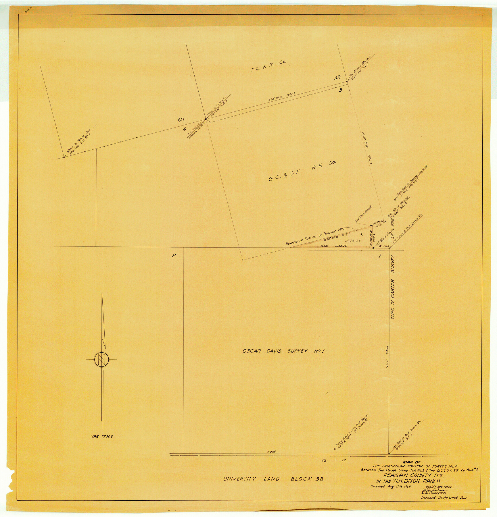
Reagan County Rolled Sketch 17A
Map of the triangular portion of survey no. 4 between the Oscar Davis sur. no. 1 & the G. C. & S. F. R.R. Co. sur #3, Reagan County, Tex. in the W.H. Dixon Ranch
-
Map/Doc
9813
-
Collection
General Map Collection
-
Object Dates
1948/8/18 (Creation Date)
-
People and Organizations
M.M. Anderson (Surveyor/Engineer)
-
Counties
Reagan
-
Subjects
Surveying Rolled Sketch
-
Height x Width
33.8 x 32.4 inches
85.9 x 82.3 cm
-
Medium
van dyke/brownline/sepia
-
Scale
1" = 200 varas
Part of: General Map Collection
Blanco County Sketch File 40

Print $4.00
- Digital $50.00
Blanco County Sketch File 40
Size 8.9 x 14.1 inches
Map/Doc 14652
Flight Mission No. DQO-8K, Frame 142, Galveston County

Print $20.00
- Digital $50.00
Flight Mission No. DQO-8K, Frame 142, Galveston County
1952
Size 18.6 x 22.3 inches
Map/Doc 85204
Liberty County Working Sketch 38

Print $20.00
- Digital $50.00
Liberty County Working Sketch 38
1951
Size 28.0 x 36.4 inches
Map/Doc 70497
Coryell County Sketch File 15

Print $4.00
- Digital $50.00
Coryell County Sketch File 15
1873
Size 13.0 x 8.5 inches
Map/Doc 19371
Bee County Sketch File 32

Print $4.00
- Digital $50.00
Bee County Sketch File 32
Size 7.9 x 12.6 inches
Map/Doc 14347
Brewster County Sketch File NS-7

Print $14.00
- Digital $50.00
Brewster County Sketch File NS-7
1945
Size 11.3 x 8.8 inches
Map/Doc 15992
Hemphill County Rolled Sketch 17

Print $40.00
- Digital $50.00
Hemphill County Rolled Sketch 17
1965
Size 24.0 x 64.1 inches
Map/Doc 9157
Brooks County Working Sketch 12

Print $20.00
- Digital $50.00
Brooks County Working Sketch 12
1943
Size 27.0 x 26.5 inches
Map/Doc 67796
Stephens County Sketch File 8

Print $40.00
- Digital $50.00
Stephens County Sketch File 8
1879
Size 13.5 x 14.2 inches
Map/Doc 37027
Flight Mission No. CGI-2N, Frame 181, Cameron County

Print $20.00
- Digital $50.00
Flight Mission No. CGI-2N, Frame 181, Cameron County
1954
Size 18.4 x 22.2 inches
Map/Doc 84541
Duval County Working Sketch 53

Print $20.00
- Digital $50.00
Duval County Working Sketch 53
1948
Size 34.7 x 37.5 inches
Map/Doc 68777
Hudspeth County Sketch File 50

Print $20.00
- Digital $50.00
Hudspeth County Sketch File 50
Size 11.2 x 8.7 inches
Map/Doc 42948
You may also like
The Republic County of Washington. January 30, 1841

Print $20.00
The Republic County of Washington. January 30, 1841
2020
Size 20.3 x 21.7 inches
Map/Doc 96305
Starr County Working Sketch 10

Print $20.00
- Digital $50.00
Starr County Working Sketch 10
1940
Size 38.1 x 32.4 inches
Map/Doc 63926
Map of Texas Showing County Names Only

Print $20.00
- Digital $50.00
Map of Texas Showing County Names Only
Size 34.2 x 43.6 inches
Map/Doc 2163
Old Miscellaneous File 25

Print $40.00
- Digital $50.00
Old Miscellaneous File 25
Size 17.8 x 15.2 inches
Map/Doc 75632
Lampasas County Sketch File 9

Print $4.00
- Digital $50.00
Lampasas County Sketch File 9
1873
Size 9.4 x 7.3 inches
Map/Doc 29408
Irion County Working Sketch 12

Print $20.00
- Digital $50.00
Irion County Working Sketch 12
1968
Size 15.9 x 24.9 inches
Map/Doc 66421
170th Anniversary Land Commissioners of the Texas General Land Office

Print $20.00
- Digital $50.00
170th Anniversary Land Commissioners of the Texas General Land Office
2006
Size 36.4 x 24.1 inches
Map/Doc 87177
Victoria County
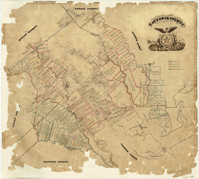
Print $20.00
- Digital $50.00
Victoria County
1858
Size 26.5 x 29.2 inches
Map/Doc 4115
San Benito, Texas on the Frisco in the Lower Rio Grande Valley

San Benito, Texas on the Frisco in the Lower Rio Grande Valley
1911
Map/Doc 96727
Coke County Sketch File 22

Print $20.00
- Digital $50.00
Coke County Sketch File 22
1923
Size 22.1 x 27.8 inches
Map/Doc 11111
Foard County Sketch File 18

Print $6.00
- Digital $50.00
Foard County Sketch File 18
1888
Size 13.0 x 8.5 inches
Map/Doc 22834
Loving County Working Sketch 22

Print $20.00
- Digital $50.00
Loving County Working Sketch 22
1984
Size 18.3 x 34.9 inches
Map/Doc 70656