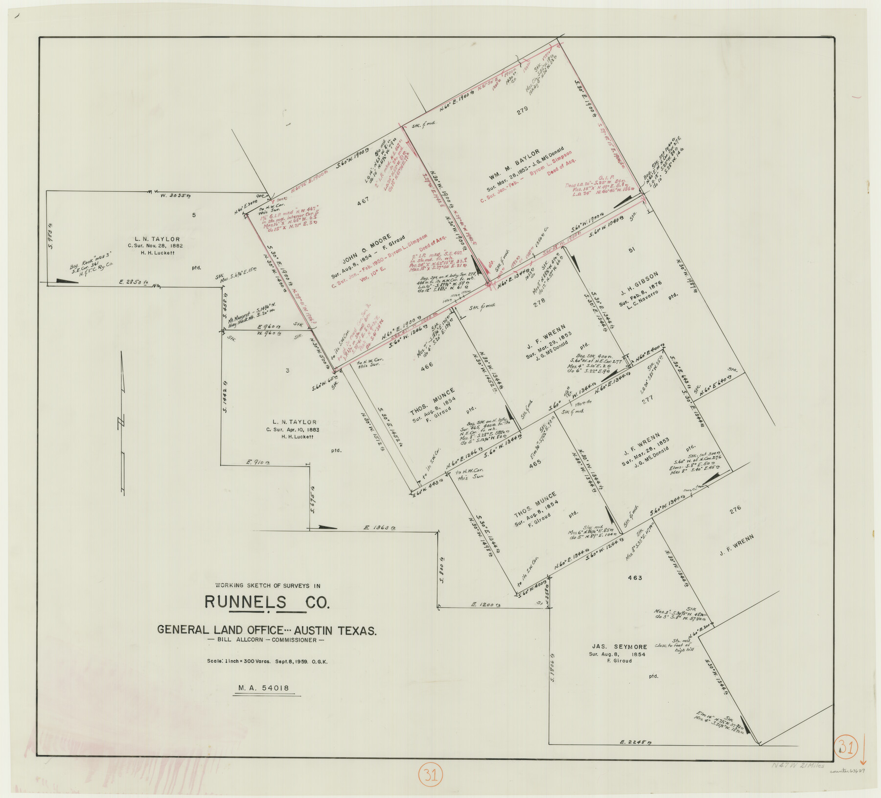
Runnels County Working Sketch 31
-
Map/Doc
63629
-
Collection
General Map Collection
-
Object Dates
9/8/1959 (Creation Date)
-
People and Organizations
Otto G. Kurio (Draftsman)
-
Counties
Runnels
-
Subjects
Surveying Working Sketch
-
Height x Width
28.3 x 31.3 inches
71.9 x 79.5 cm
-
Scale
1" = 300 varas
Part of: General Map Collection
Bell County Sketch File 12

Print $4.00
- Digital $50.00
Bell County Sketch File 12
1852
Size 8.1 x 12.5 inches
Map/Doc 14385
Polk County Working Sketch 29

Print $40.00
- Digital $50.00
Polk County Working Sketch 29
1960
Size 56.0 x 45.0 inches
Map/Doc 71645
Map of the Houston & Great Northern Railroad

Print $40.00
- Digital $50.00
Map of the Houston & Great Northern Railroad
1871
Size 29.3 x 122.1 inches
Map/Doc 64551
Smith County Working Sketch 10

Print $20.00
- Digital $50.00
Smith County Working Sketch 10
1952
Size 33.4 x 24.2 inches
Map/Doc 63895
Menard County Sketch File 2

Print $22.00
- Digital $50.00
Menard County Sketch File 2
1881
Size 7.9 x 12.8 inches
Map/Doc 31486
McCulloch County Sketch File 8

Print $4.00
- Digital $50.00
McCulloch County Sketch File 8
1904
Size 11.3 x 8.7 inches
Map/Doc 31182
Hudspeth County Rolled Sketch 52

Print $20.00
- Digital $50.00
Hudspeth County Rolled Sketch 52
1975
Size 27.2 x 21.6 inches
Map/Doc 6257
Armstrong County Rolled Sketch B1

Print $20.00
- Digital $50.00
Armstrong County Rolled Sketch B1
1903
Size 25.8 x 37.8 inches
Map/Doc 5085
Glasscock County Sketch File 22

Print $20.00
- Digital $50.00
Glasscock County Sketch File 22
Size 13.8 x 18.6 inches
Map/Doc 11565
Bexar County Sketch File 1a

Print $24.00
- Digital $50.00
Bexar County Sketch File 1a
1847
Size 12.7 x 8.2 inches
Map/Doc 14468
Flight Mission No. DCL-7C, Frame 56, Kenedy County

Print $20.00
- Digital $50.00
Flight Mission No. DCL-7C, Frame 56, Kenedy County
1943
Size 15.4 x 15.2 inches
Map/Doc 86044
Aransas County Rolled Sketch 19

Print $20.00
- Digital $50.00
Aransas County Rolled Sketch 19
1979
Size 24.8 x 36.7 inches
Map/Doc 82559
You may also like
Webb County Rolled Sketch EF1

Print $20.00
- Digital $50.00
Webb County Rolled Sketch EF1
1931
Size 40.3 x 30.0 inches
Map/Doc 8223
Jack County Sketch File 24

Print $4.00
- Digital $50.00
Jack County Sketch File 24
1880
Size 8.3 x 9.5 inches
Map/Doc 27561
VanZandt County Showing the Located Route of the Texas and Pacific R.R.

Print $20.00
- Digital $50.00
VanZandt County Showing the Located Route of the Texas and Pacific R.R.
1872
Size 24.5 x 22.3 inches
Map/Doc 64136
Tyler County Rolled Sketch 2

Print $20.00
- Digital $50.00
Tyler County Rolled Sketch 2
1944
Size 29.6 x 17.4 inches
Map/Doc 8056
Kinney County Working Sketch 58

Print $20.00
- Digital $50.00
Kinney County Working Sketch 58
1996
Size 36.1 x 31.7 inches
Map/Doc 70240
Map of Anderson County

Print $20.00
- Digital $50.00
Map of Anderson County
1895
Size 46.7 x 37.5 inches
Map/Doc 4866
Kinney County Sketch File 39

Print $20.00
- Digital $50.00
Kinney County Sketch File 39
1948
Size 18.8 x 21.0 inches
Map/Doc 11951
Cottle County Sketch File 7 1/2

Print $26.00
- Digital $50.00
Cottle County Sketch File 7 1/2
1889
Size 40.2 x 21.0 inches
Map/Doc 10342
Galveston Bay and Approaches

Print $20.00
- Digital $50.00
Galveston Bay and Approaches
1957
Size 43.6 x 32.7 inches
Map/Doc 69877
Kimble County Rolled Sketch 40

Print $20.00
- Digital $50.00
Kimble County Rolled Sketch 40
Size 27.5 x 22.4 inches
Map/Doc 6530
Jefferson County Rolled Sketch 61E

Print $20.00
- Digital $50.00
Jefferson County Rolled Sketch 61E
1928
Size 27.1 x 40.2 inches
Map/Doc 6414
Republic Counties. January 1, 1845

Print $20.00
Republic Counties. January 1, 1845
2020
Size 24.5 x 21.7 inches
Map/Doc 96318