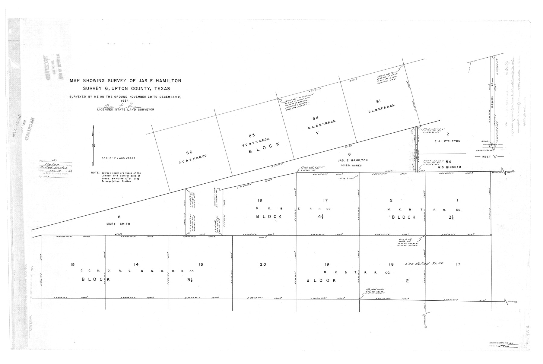
Upton County Rolled Sketch 41
Map showing survey of Jas. E. Hamilton survey 6, Upton County, Texas
-
Map/Doc
8080
-
Collection
General Map Collection
-
Object Dates
1954/12/2 (Survey Date)
1955/1/10 (File Date)
-
People and Organizations
Byron L. Simpson (Surveyor/Engineer)
-
Counties
Upton
-
Subjects
Surveying Rolled Sketch
-
Height x Width
27.4 x 40.8 inches
69.6 x 103.6 cm
-
Medium
linen, manuscript
-
Scale
1" = 400 varas
Part of: General Map Collection
Montague County Working Sketch 24

Print $20.00
- Digital $50.00
Montague County Working Sketch 24
1953
Size 21.9 x 27.6 inches
Map/Doc 71090
Zapata County Working Sketch 3

Print $20.00
- Digital $50.00
Zapata County Working Sketch 3
1932
Size 18.0 x 13.6 inches
Map/Doc 62054
Trinity River, Emhouse Sheet/Chambers Creek

Print $6.00
- Digital $50.00
Trinity River, Emhouse Sheet/Chambers Creek
1931
Size 35.3 x 34.8 inches
Map/Doc 65232
[Surveys along the Nueces River in San Patricio County]
![69737, [Surveys along the Nueces River in San Patricio County], General Map Collection](https://historictexasmaps.com/wmedia_w700/maps/69737.tif.jpg)
Print $2.00
- Digital $50.00
[Surveys along the Nueces River in San Patricio County]
1842
Size 8.8 x 9.9 inches
Map/Doc 69737
Galveston County NRC Article 33.136 Sketch 32

Print $26.00
- Digital $50.00
Galveston County NRC Article 33.136 Sketch 32
2005
Size 24.5 x 36.8 inches
Map/Doc 83173
Flight Mission No. DIX-6P, Frame 126, Aransas County

Print $20.00
- Digital $50.00
Flight Mission No. DIX-6P, Frame 126, Aransas County
1956
Size 19.3 x 22.9 inches
Map/Doc 83832
Colorado County Rolled Sketch 3

Print $20.00
- Digital $50.00
Colorado County Rolled Sketch 3
1943
Size 43.6 x 40.2 inches
Map/Doc 8642
Hutchinson County Rolled Sketch 44-5

Print $20.00
- Digital $50.00
Hutchinson County Rolled Sketch 44-5
2002
Size 24.0 x 36.0 inches
Map/Doc 77541
Harris County Sketch File 1

Print $20.00
- Digital $50.00
Harris County Sketch File 1
Size 14.8 x 12.6 inches
Map/Doc 25332
Winkler County Working Sketch 8

Print $20.00
- Digital $50.00
Winkler County Working Sketch 8
1958
Size 31.9 x 30.7 inches
Map/Doc 72602
[Atlas A, Table of Contents, part 2]
![82085, [Atlas A, Table of Contents, part 2], General Map Collection](https://historictexasmaps.com/wmedia_w700/maps/82085.tif.jpg)
Print $2.00
- Digital $50.00
[Atlas A, Table of Contents, part 2]
Size 7.0 x 11.8 inches
Map/Doc 82085
Irion County Working Sketch 9

Print $20.00
- Digital $50.00
Irion County Working Sketch 9
1941
Size 13.6 x 17.2 inches
Map/Doc 66418
You may also like
The Republic County of San Patricio. 1840

Print $20.00
The Republic County of San Patricio. 1840
2020
Size 22.2 x 21.7 inches
Map/Doc 96276
[Leagues 7, 8, 9, and 10]
![92220, [Leagues 7, 8, 9, and 10], Twichell Survey Records](https://historictexasmaps.com/wmedia_w700/maps/92220-1.tif.jpg)
Print $20.00
- Digital $50.00
[Leagues 7, 8, 9, and 10]
1943
Size 18.3 x 12.2 inches
Map/Doc 92220

[Map of Matagorda County]
![3841, [Map of Matagorda County], General Map Collection](https://historictexasmaps.com/wmedia_w700/maps/3841.tif.jpg)
Print $20.00
- Digital $50.00
[Map of Matagorda County]
Size 24.4 x 25.6 inches
Map/Doc 3841

Gillespie County Working Sketch 9

Print $20.00
- Digital $50.00
Gillespie County Working Sketch 9
1994
Size 27.7 x 32.3 inches
Map/Doc 63172

El Paso County Sketch File 21

Print $35.00
- Digital $50.00
El Paso County Sketch File 21
1916
Size 14.5 x 9.1 inches
Map/Doc 22014
Wharton County Sketch File 4

Print $20.00
- Digital $50.00
Wharton County Sketch File 4
Size 26.9 x 16.2 inches
Map/Doc 12659
Archer County Boundary File 4

Print $54.00
- Digital $50.00
Archer County Boundary File 4
Size 8.9 x 9.7 inches
Map/Doc 50103
Johnson County, Texas

Print $20.00
- Digital $50.00
Johnson County, Texas
1871
Size 18.2 x 23.3 inches
Map/Doc 734
Grayson County Sketch File 9

Print $4.00
- Digital $50.00
Grayson County Sketch File 9
1857
Size 12.1 x 8.1 inches
Map/Doc 24472