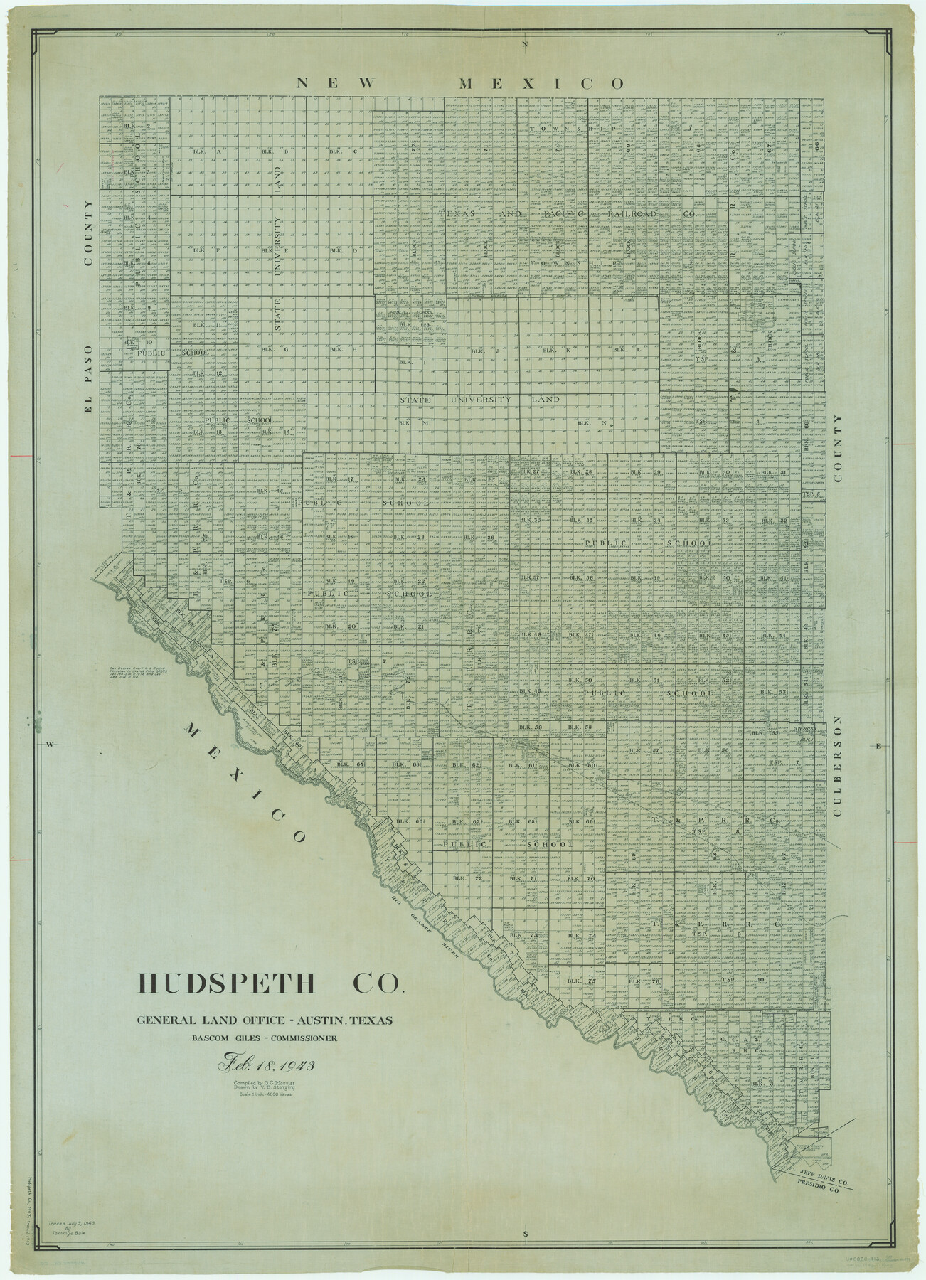
Hudspeth Co.
-
Map/Doc
66874
-
Collection
General Map Collection
-
Object Dates
1943/2/18 (Creation Date)
-
People and Organizations
Texas General Land Office (Publisher)
Bascom Giles (GLO Commissioner)
Victor E. Sterzing (Draftsman)
G.C. Morriss (Compiler)
-
Counties
Hudspeth
-
Subjects
County
-
Height x Width
53.9 x 39.0 inches
136.9 x 99.1 cm
-
Comments
Traced July 3, 1943 by Tommye Buie.
Part of: General Map Collection
Brazoria County Working Sketch 29

Print $20.00
- Digital $50.00
Brazoria County Working Sketch 29
1971
Size 30.6 x 28.3 inches
Map/Doc 67514
Coke County Rolled Sketch 14A

Print $20.00
- Digital $50.00
Coke County Rolled Sketch 14A
Size 21.0 x 14.1 inches
Map/Doc 5515
Morris County Rolled Sketch 2A

Print $20.00
- Digital $50.00
Morris County Rolled Sketch 2A
Size 24.4 x 19.2 inches
Map/Doc 10271
Culberson County Rolled Sketch 49

Print $20.00
- Digital $50.00
Culberson County Rolled Sketch 49
1961
Size 22.4 x 29.0 inches
Map/Doc 5668
Andrews County Rolled Sketch 34

Print $20.00
- Digital $50.00
Andrews County Rolled Sketch 34
1955
Size 34.9 x 40.0 inches
Map/Doc 8913
Galveston Bay and Approaches
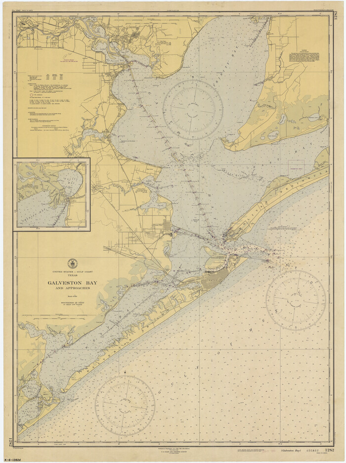
Print $20.00
- Digital $50.00
Galveston Bay and Approaches
1946
Size 45.5 x 34.0 inches
Map/Doc 69876
King County Sketch File 7

Print $72.00
- Digital $50.00
King County Sketch File 7
1901
Size 11.1 x 8.5 inches
Map/Doc 29030
Bell County Sketch File 33

Print $6.00
- Digital $50.00
Bell County Sketch File 33
Size 14.4 x 8.7 inches
Map/Doc 14452
Flight Mission No. DCL-7C, Frame 122, Kenedy County

Print $20.00
- Digital $50.00
Flight Mission No. DCL-7C, Frame 122, Kenedy County
1943
Size 18.6 x 22.4 inches
Map/Doc 86087
Reeves County Rolled Sketch 20

Print $20.00
- Digital $50.00
Reeves County Rolled Sketch 20
Size 32.1 x 38.4 inches
Map/Doc 9852
Nolan County Sketch File 8

Print $2.00
- Digital $50.00
Nolan County Sketch File 8
Size 11.3 x 8.8 inches
Map/Doc 32464
Flight Mission No. BRE-2P, Frame 96, Nueces County

Print $20.00
- Digital $50.00
Flight Mission No. BRE-2P, Frame 96, Nueces County
1956
Size 18.4 x 22.3 inches
Map/Doc 86781
You may also like
Baylor County Aerial Photograph Index Sheet 3

Print $20.00
- Digital $50.00
Baylor County Aerial Photograph Index Sheet 3
1950
Size 20.4 x 15.5 inches
Map/Doc 83665
Webb County Rolled Sketch D

Print $20.00
- Digital $50.00
Webb County Rolled Sketch D
1897
Size 25.4 x 40.6 inches
Map/Doc 8222
English Field Notes of the Spanish Archives - Book S

English Field Notes of the Spanish Archives - Book S
1835
Map/Doc 96543
Glasscock County Rolled Sketch 15

Print $20.00
- Digital $50.00
Glasscock County Rolled Sketch 15
1964
Size 36.5 x 35.8 inches
Map/Doc 9059
Hood County Rolled Sketch 7

Print $20.00
- Digital $50.00
Hood County Rolled Sketch 7
2009
Size 19.1 x 24.5 inches
Map/Doc 89062
[Sketch for Mineral Application 24072, San Jacinto River]
![65608, [Sketch for Mineral Application 24072, San Jacinto River], General Map Collection](https://historictexasmaps.com/wmedia_w700/maps/65608.tif.jpg)
Print $20.00
- Digital $50.00
[Sketch for Mineral Application 24072, San Jacinto River]
1929
Size 8.6 x 14.0 inches
Map/Doc 65608
Wilbarger Co.

Print $40.00
- Digital $50.00
Wilbarger Co.
1907
Size 48.8 x 39.8 inches
Map/Doc 63127
Hays County Rolled Sketch 26

Print $20.00
- Digital $50.00
Hays County Rolled Sketch 26
1943
Size 27.7 x 25.6 inches
Map/Doc 6182
Under Sapphire Skies San Antonio

Under Sapphire Skies San Antonio
1928
Size 9.4 x 6.4 inches
Map/Doc 97043
Outer Continental Shelf Leasing Maps (Texas Offshore Operations)

Print $20.00
- Digital $50.00
Outer Continental Shelf Leasing Maps (Texas Offshore Operations)
Size 24.3 x 18.5 inches
Map/Doc 75851
Map of Austin's Little Colony

Print $20.00
- Digital $50.00
Map of Austin's Little Colony
Size 19.0 x 23.3 inches
Map/Doc 76007
