Colorado County Rolled Sketch 3
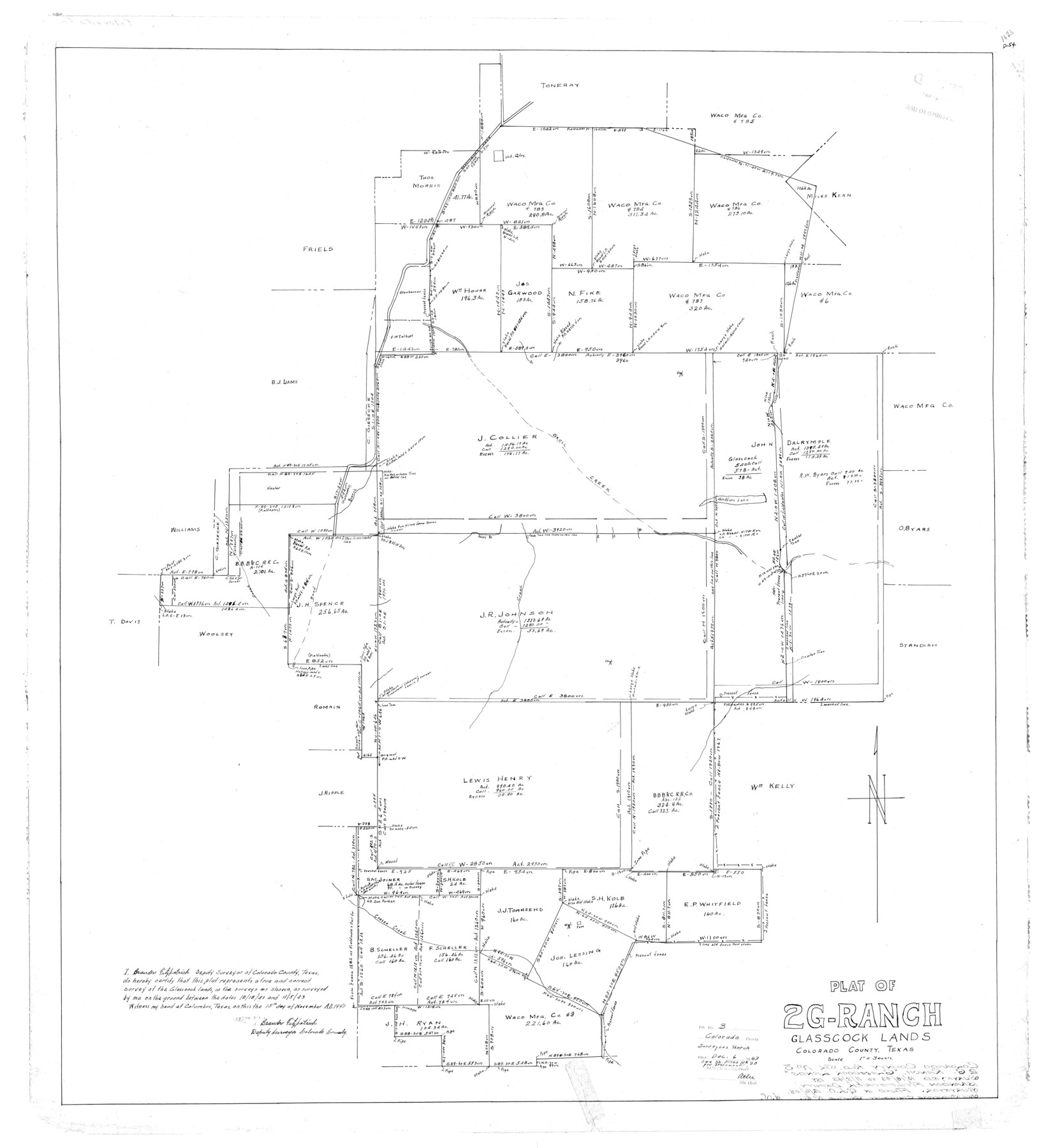
Plat of 2G-Ranch Glasscock Lands, Colorado County, Texas
-
Map/Doc
8642
-
Collection
General Map Collection
-
Object Dates
1943/11/5 (Creation Date)
1943/12/6 (File Date)
-
People and Organizations
Brandon Fitzpatrick (Surveyor/Engineer)
-
Counties
Colorado
-
Subjects
Surveying Rolled Sketch
-
Height x Width
43.6 x 40.2 inches
110.7 x 102.1 cm
-
Scale
1" = 300 varas
-
Comments
See Colorado County Sketch File 30 (18977) for surveyor’s statement.
Related maps
Colorado County Sketch File 30

Print $14.00
- Digital $50.00
Colorado County Sketch File 30
1943
Size 14.1 x 8.6 inches
Map/Doc 18977
Part of: General Map Collection
Montgomery County Sketch File 12

Print $2.00
- Digital $50.00
Montgomery County Sketch File 12
Size 8.1 x 3.8 inches
Map/Doc 31802
McLennan County Sketch File 35

Print $10.00
- Digital $50.00
McLennan County Sketch File 35
Size 13.1 x 8.1 inches
Map/Doc 31310
Real County Rolled Sketch 18

Print $20.00
- Digital $50.00
Real County Rolled Sketch 18
1986
Size 24.9 x 31.9 inches
Map/Doc 7468
Crane County Rolled Sketch 21

Print $20.00
- Digital $50.00
Crane County Rolled Sketch 21
1988
Size 42.5 x 36.6 inches
Map/Doc 8685
Matagorda Bay Oil Area, Matagorda, Calhoun & Jackson Cos.

Print $40.00
- Digital $50.00
Matagorda Bay Oil Area, Matagorda, Calhoun & Jackson Cos.
1927
Size 34.9 x 66.8 inches
Map/Doc 2934
Presidio County Rolled Sketch 30

Print $40.00
- Digital $50.00
Presidio County Rolled Sketch 30
Size 40.8 x 84.9 inches
Map/Doc 9767
San Patricio County Working Sketch 25

Print $20.00
- Digital $50.00
San Patricio County Working Sketch 25
1951
Size 20.3 x 25.4 inches
Map/Doc 63787
Eastland County Working Sketch 57

Print $20.00
- Digital $50.00
Eastland County Working Sketch 57
1985
Size 21.7 x 21.8 inches
Map/Doc 68838
Aransas County Rolled Sketch 35

Print $40.00
- Digital $50.00
Aransas County Rolled Sketch 35
2006
Size 37.5 x 50.0 inches
Map/Doc 83555
Shackelford County Sketch File 1

Print $4.00
- Digital $50.00
Shackelford County Sketch File 1
1877
Size 12.8 x 8.0 inches
Map/Doc 36570
Chambers County Sketch File 19

Print $26.00
- Digital $50.00
Chambers County Sketch File 19
Size 14.1 x 8.6 inches
Map/Doc 17578
Kerr County Rolled Sketch 25

Print $20.00
- Digital $50.00
Kerr County Rolled Sketch 25
Size 24.7 x 31.0 inches
Map/Doc 6505
You may also like
San Jacinto River and Tributaries, Texas - Survey of 1939

Print $20.00
- Digital $50.00
San Jacinto River and Tributaries, Texas - Survey of 1939
1939
Size 27.7 x 40.4 inches
Map/Doc 60306
Reeves County Rolled Sketch 17

Print $20.00
- Digital $50.00
Reeves County Rolled Sketch 17
1963
Size 28.4 x 36.1 inches
Map/Doc 7486
Upper Galveston Bay, Houston Ship Channel, Dollar Pt. to Atkinson I.

Print $40.00
- Digital $50.00
Upper Galveston Bay, Houston Ship Channel, Dollar Pt. to Atkinson I.
1972
Size 49.9 x 36.9 inches
Map/Doc 69895
Hunt County Working Sketch 2

Print $20.00
- Digital $50.00
Hunt County Working Sketch 2
Size 20.5 x 16.5 inches
Map/Doc 66349
[Beaumont, Sour Lake and Western Ry. Right of Way and Alignment - Frisco]
![64122, [Beaumont, Sour Lake and Western Ry. Right of Way and Alignment - Frisco], General Map Collection](https://historictexasmaps.com/wmedia_w700/maps/64122.tif.jpg)
Print $20.00
- Digital $50.00
[Beaumont, Sour Lake and Western Ry. Right of Way and Alignment - Frisco]
1910
Size 19.8 x 45.9 inches
Map/Doc 64122
Current Miscellaneous File 83

Print $2.00
- Digital $50.00
Current Miscellaneous File 83
1936
Size 8.3 x 10.6 inches
Map/Doc 74226
Crane County Sketch File 3

Print $20.00
- Digital $50.00
Crane County Sketch File 3
Size 23.6 x 26.0 inches
Map/Doc 11204
Starr County Working Sketch 18

Print $20.00
- Digital $50.00
Starr County Working Sketch 18
1982
Size 29.5 x 34.3 inches
Map/Doc 63934
Flight Mission No. DQO-2K, Frame 144, Galveston County

Print $20.00
- Digital $50.00
Flight Mission No. DQO-2K, Frame 144, Galveston County
1952
Size 18.8 x 22.5 inches
Map/Doc 85041
McMullen County Working Sketch 5

Print $20.00
- Digital $50.00
McMullen County Working Sketch 5
1923
Size 21.8 x 19.0 inches
Map/Doc 70706

Brewster County Working Sketch 9

Print $20.00
- Digital $50.00
Brewster County Working Sketch 9
1910
Size 14.3 x 14.4 inches
Map/Doc 67542