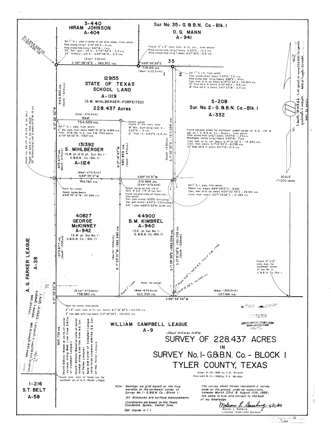
Tyler County Rolled Sketch 12
Survey of 228.437 acres in survey no. 1 - G. & B. N. Co. - Block 1, Tyler County, Texas
-
Map/Doc
8060
-
Collection
General Map Collection
-
Object Dates
1988/8/10 (Survey Date)
1989/6/23 (File Date)
1988/8/25 (Creation Date)
1988/8/31 (Revision Date)
1989/6/21 (Creation Date)
-
People and Organizations
Malcom L. Bamburg (Surveyor/Engineer)
C.B. Strauch (Draftsman)
P.K. Murphy (Draftsman)
-
Counties
Tyler
-
Subjects
Surveying Rolled Sketch
-
Height x Width
25.2 x 19.3 inches
64.0 x 49.0 cm
-
Medium
mylar, print
Related maps
Tyler County Sketch File 30

Print $4.00
- Digital $50.00
Tyler County Sketch File 30
1989
Size 14.3 x 8.8 inches
Map/Doc 38721
Part of: General Map Collection
Pecos County Rolled Sketch 108

Print $20.00
- Digital $50.00
Pecos County Rolled Sketch 108
1940
Size 39.7 x 30.7 inches
Map/Doc 7254
Sabine County Sketch File 9

Print $6.00
Sabine County Sketch File 9
1912
Size 12.7 x 8.0 inches
Map/Doc 35624
Jefferson County Rolled Sketch 64

Print $20.00
- Digital $50.00
Jefferson County Rolled Sketch 64
1982
Size 26.7 x 37.4 inches
Map/Doc 9319
Sabine County

Print $20.00
- Digital $50.00
Sabine County
1920
Size 45.7 x 36.1 inches
Map/Doc 95631
Map of The Surveyed Part of Peters Colony Texas

Print $40.00
- Digital $50.00
Map of The Surveyed Part of Peters Colony Texas
1854
Size 53.7 x 32.0 inches
Map/Doc 83007
Located Line of the Panhandle & Gulf Ry. Through State Lands, Public School and University, in Crockett County, Texas

Print $20.00
- Digital $50.00
Located Line of the Panhandle & Gulf Ry. Through State Lands, Public School and University, in Crockett County, Texas
1904
Size 12.2 x 27.3 inches
Map/Doc 64287
Val Verde County Sketch File 2

Print $8.00
- Digital $50.00
Val Verde County Sketch File 2
1885
Size 12.8 x 8.0 inches
Map/Doc 39169
[Overlay for Fractional Township No. 7 South Range No. 17 East of the Indian Meridian, Indian Territory]
![75230, [Overlay for Fractional Township No. 7 South Range No. 17 East of the Indian Meridian, Indian Territory], General Map Collection](https://historictexasmaps.com/wmedia_w700/maps/75230.tif.jpg)
Print $3.00
- Digital $50.00
[Overlay for Fractional Township No. 7 South Range No. 17 East of the Indian Meridian, Indian Territory]
Size 11.2 x 11.7 inches
Map/Doc 75230
Goliad County Sketch File 41

Print $20.00
- Digital $50.00
Goliad County Sketch File 41
1958
Size 25.2 x 35.3 inches
Map/Doc 11573
Kleberg County Rolled Sketch 10-10

Print $20.00
- Digital $50.00
Kleberg County Rolled Sketch 10-10
1951
Size 38.7 x 32.7 inches
Map/Doc 9389
Webb County Working Sketch 15

Print $20.00
- Digital $50.00
Webb County Working Sketch 15
1923
Size 18.8 x 30.4 inches
Map/Doc 72380
PSL Field Notes for Blocks A19, A20, A22, A23, A26, A28, A29, A30, A31, A32, A33, A34, A35, A36, A37, A38, A39, A40, A41 in Andrews County

PSL Field Notes for Blocks A19, A20, A22, A23, A26, A28, A29, A30, A31, A32, A33, A34, A35, A36, A37, A38, A39, A40, A41 in Andrews County
Map/Doc 81642
You may also like
Anderson County Sketch File 19

Print $40.00
- Digital $50.00
Anderson County Sketch File 19
Size 18.2 x 15.9 inches
Map/Doc 10802
[F. W. & D. C. Ry. Co. Alignment and Right of Way Map, Clay County]
![64746, [F. W. & D. C. Ry. Co. Alignment and Right of Way Map, Clay County], General Map Collection](https://historictexasmaps.com/wmedia_w700/maps/64746-GC.tif.jpg)
Print $20.00
- Digital $50.00
[F. W. & D. C. Ry. Co. Alignment and Right of Way Map, Clay County]
1927
Size 18.7 x 11.9 inches
Map/Doc 64746
Sketch of Surveys in Crosby and Garza Cos.

Print $20.00
- Digital $50.00
Sketch of Surveys in Crosby and Garza Cos.
Size 19.7 x 25.3 inches
Map/Doc 90338
Edwards County Working Sketch 81

Print $40.00
- Digital $50.00
Edwards County Working Sketch 81
1964
Size 61.4 x 39.6 inches
Map/Doc 68957
Flight Mission No. BRA-8M, Frame 72, Jefferson County

Print $20.00
- Digital $50.00
Flight Mission No. BRA-8M, Frame 72, Jefferson County
1953
Size 18.6 x 22.2 inches
Map/Doc 85592
St. L. S-W. Ry. of Texas Map of Lufkin Branch in Cherokee County Texas

Print $40.00
- Digital $50.00
St. L. S-W. Ry. of Texas Map of Lufkin Branch in Cherokee County Texas
1912
Size 22.7 x 64.3 inches
Map/Doc 64019
Anderson County Boundary File 10

Print $13.00
- Digital $50.00
Anderson County Boundary File 10
Size 16.0 x 10.2 inches
Map/Doc 49759
Montgomery County Rolled Sketch 48

Print $20.00
- Digital $50.00
Montgomery County Rolled Sketch 48
2007
Size 11.2 x 17.2 inches
Map/Doc 89278
Walker County Working Sketch 11

Print $20.00
- Digital $50.00
Walker County Working Sketch 11
1935
Size 28.2 x 38.8 inches
Map/Doc 72291
Ward County Rolled Sketch 24F

Print $40.00
- Digital $50.00
Ward County Rolled Sketch 24F
Size 30.5 x 65.2 inches
Map/Doc 78232
Flight Mission No. CRC-1R, Frame 156, Chambers County

Print $20.00
- Digital $50.00
Flight Mission No. CRC-1R, Frame 156, Chambers County
1956
Size 18.7 x 22.5 inches
Map/Doc 84718
General Highway Map, Goliad County, Texas

Print $20.00
General Highway Map, Goliad County, Texas
1961
Size 18.2 x 24.7 inches
Map/Doc 79481