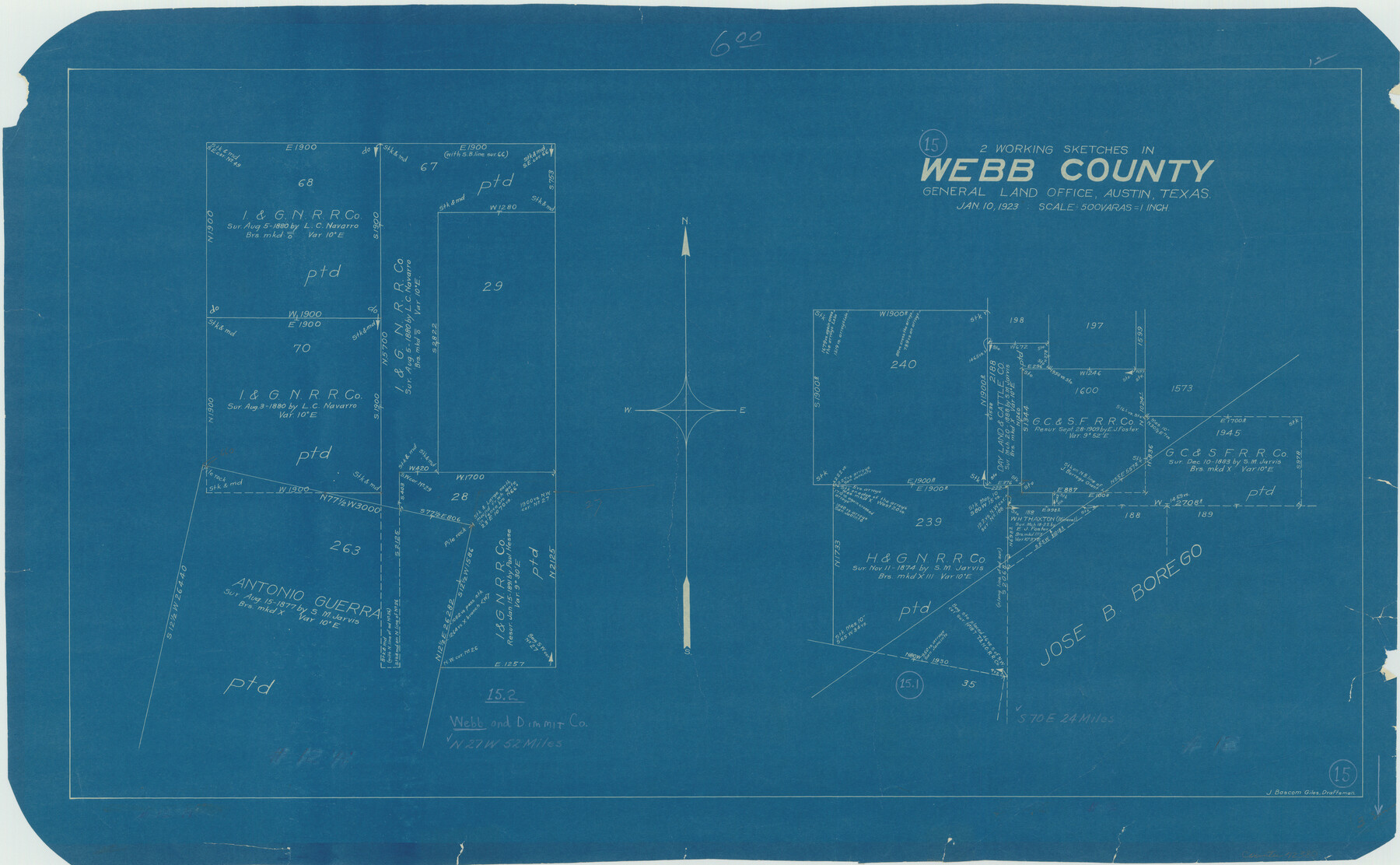
Webb County Working Sketch 15
-
Map/Doc
72380
-
Collection
General Map Collection
-
Object Dates
1/10/1923 (Creation Date)
-
People and Organizations
J. Bascom Giles (Draftsman)
-
Counties
Webb
-
Subjects
Surveying Working Sketch
-
Height x Width
18.8 x 30.4 inches
47.8 x 77.2 cm
-
Scale
1" = 500 varas
Part of: General Map Collection
Hays County Working Sketch 8

Print $20.00
- Digital $50.00
Hays County Working Sketch 8
1942
Size 27.1 x 30.9 inches
Map/Doc 66082
Hudspeth County Working Sketch 25

Print $20.00
- Digital $50.00
Hudspeth County Working Sketch 25
1971
Size 24.6 x 28.0 inches
Map/Doc 66307
Burnet County Rolled Sketch 3

Print $20.00
- Digital $50.00
Burnet County Rolled Sketch 3
Size 23.7 x 26.2 inches
Map/Doc 5355
Trinity County Boundary File 102a

Print $50.00
- Digital $50.00
Trinity County Boundary File 102a
Size 9.6 x 4.7 inches
Map/Doc 59487
Harris County Sketch File 49

Print $10.00
- Digital $50.00
Harris County Sketch File 49
1908
Size 11.4 x 9.0 inches
Map/Doc 25446
[Nueces Bay, Mustang Island and Padre Island]
![73466, [Nueces Bay, Mustang Island and Padre Island], General Map Collection](https://historictexasmaps.com/wmedia_w700/maps/73466.tif.jpg)
Print $4.00
- Digital $50.00
[Nueces Bay, Mustang Island and Padre Island]
Size 18.3 x 25.3 inches
Map/Doc 73466
Presidio County Working Sketch Graphic Index, South Part, Sheet 1 (Sketches 1 to 44)

Print $20.00
- Digital $50.00
Presidio County Working Sketch Graphic Index, South Part, Sheet 1 (Sketches 1 to 44)
1975
Size 32.3 x 38.0 inches
Map/Doc 76670

Dawson County Sketch File 11

Print $20.00
- Digital $50.00
Dawson County Sketch File 11
1927
Size 18.6 x 20.9 inches
Map/Doc 11293
Andrews County Working Sketch 32

Print $20.00
- Digital $50.00
Andrews County Working Sketch 32
1990
Size 29.6 x 31.5 inches
Map/Doc 67078
Irion County Rolled Sketch 24

Print $40.00
- Digital $50.00
Irion County Rolled Sketch 24
Size 49.4 x 37.4 inches
Map/Doc 9257

You may also like
Flight Mission No. CUG-1P, Frame 5, Kleberg County

Print $20.00
- Digital $50.00
Flight Mission No. CUG-1P, Frame 5, Kleberg County
1956
Size 18.8 x 22.5 inches
Map/Doc 86108
Schleicher County Rolled Sketch 18

Print $20.00
- Digital $50.00
Schleicher County Rolled Sketch 18
Size 31.6 x 27.9 inches
Map/Doc 7760
Gregg County Rolled Sketch 17

Print $20.00
- Digital $50.00
Gregg County Rolled Sketch 17
1933
Size 14.2 x 27.5 inches
Map/Doc 6041
Ward County Boundary File 3

Print $18.00
- Digital $50.00
Ward County Boundary File 3
Size 14.4 x 8.8 inches
Map/Doc 59675
Harrison County State Real Property Sketch 2

Print $20.00
- Digital $50.00
Harrison County State Real Property Sketch 2
1986
Size 23.9 x 25.0 inches
Map/Doc 61667
[Surveys in the Milam District on Coryell Creek and the Bosque River]
![3171, [Surveys in the Milam District on Coryell Creek and the Bosque River], General Map Collection](https://historictexasmaps.com/wmedia_w700/maps/3171.tif.jpg)
Print $20.00
- Digital $50.00
[Surveys in the Milam District on Coryell Creek and the Bosque River]
1846
Size 14.0 x 15.8 inches
Map/Doc 3171
Uvalde County Sketch File 27

Print $20.00
- Digital $50.00
Uvalde County Sketch File 27
1972
Size 18.7 x 14.0 inches
Map/Doc 75972
Johnson County Sketch File 5

Print $20.00
- Digital $50.00
Johnson County Sketch File 5
1874
Size 33.3 x 14.3 inches
Map/Doc 11890
Colorado River, Lissie Sheet

Print $20.00
- Digital $50.00
Colorado River, Lissie Sheet
1941
Size 24.2 x 43.0 inches
Map/Doc 65306
Hale County Sketch File 26

Print $40.00
- Digital $50.00
Hale County Sketch File 26
1911
Size 20.7 x 54.4 inches
Map/Doc 10471
Map of Hidalgo County

Print $20.00
- Digital $50.00
Map of Hidalgo County
1896
Size 44.7 x 26.7 inches
Map/Doc 4978
Bexar County Working Sketch 6

Print $40.00
- Digital $50.00
Bexar County Working Sketch 6
1945
Size 56.4 x 41.2 inches
Map/Doc 67322