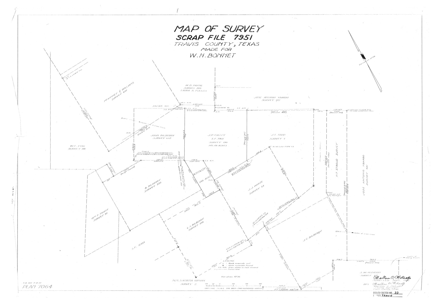
Travis County Rolled Sketch 33
Map of survey, Scrap File 7951, Travis County, Texas made for W.H. Bonnet
-
Map/Doc
8034
-
Collection
General Map Collection
-
Object Dates
1946 (Survey Date)
1948/6/29 (File Date)
-
People and Organizations
Marlton O. Metcalfe (Surveyor/Engineer)
-
Counties
Travis
-
Subjects
Surveying Rolled Sketch
-
Height x Width
22.7 x 32.7 inches
57.7 x 83.1 cm
-
Scale
1" = 200 varas
Part of: General Map Collection
Milam County Working Sketch 15

Print $20.00
- Digital $50.00
Milam County Working Sketch 15
1911
Size 18.2 x 26.1 inches
Map/Doc 71030
El Paso County Rolled Sketch 38
Print $40.00
- Digital $50.00
El Paso County Rolled Sketch 38
1922
Size 14.1 x 61.3 inches
Map/Doc 8866
Pecos County Rolled Sketch 188

Print $40.00
- Digital $50.00
Pecos County Rolled Sketch 188
1984
Size 59.4 x 43.5 inches
Map/Doc 9753

Fractional Township No. 7 South Range No. 4 East of the Indian Meridian, Indian Territory

Print $20.00
- Digital $50.00
Fractional Township No. 7 South Range No. 4 East of the Indian Meridian, Indian Territory
1898
Size 19.3 x 24.4 inches
Map/Doc 75207
Gray County Working Sketch Graphic Index

Print $20.00
- Digital $50.00
Gray County Working Sketch Graphic Index
1900
Size 43.3 x 39.4 inches
Map/Doc 76557
Culberson County Rolled Sketch 18

Print $6.00
- Digital $50.00
Culberson County Rolled Sketch 18
1911
Size 24.1 x 34.5 inches
Map/Doc 5650
Parker County Working Sketch 1

Print $20.00
- Digital $50.00
Parker County Working Sketch 1
Size 22.6 x 17.0 inches
Map/Doc 71451
Denton County Sketch File 9

Print $6.00
- Digital $50.00
Denton County Sketch File 9
1856
Size 8.6 x 13.3 inches
Map/Doc 20705
Wharton County Boundary File 1

Print $24.00
- Digital $50.00
Wharton County Boundary File 1
Size 14.2 x 8.9 inches
Map/Doc 59839
Sketch showing surveys on Harbor Island in Nueces County

Print $20.00
- Digital $50.00
Sketch showing surveys on Harbor Island in Nueces County
1978
Size 46.4 x 36.0 inches
Map/Doc 2020
Trinity River, Club House Sheet

Print $20.00
- Digital $50.00
Trinity River, Club House Sheet
1925
Size 27.7 x 23.7 inches
Map/Doc 69688
You may also like
Hemphill County Sketch File 3

Print $8.00
- Digital $50.00
Hemphill County Sketch File 3
Size 11.4 x 6.5 inches
Map/Doc 26285
Ward County Rolled Sketch 15

Print $20.00
- Digital $50.00
Ward County Rolled Sketch 15
1941
Size 26.9 x 39.2 inches
Map/Doc 8158
Map of Kendall County

Print $20.00
- Digital $50.00
Map of Kendall County
1899
Size 37.9 x 33.9 inches
Map/Doc 4678
Rusk County Sketch File 47

Print $8.00
Rusk County Sketch File 47
Size 12.7 x 7.9 inches
Map/Doc 35597
Bosque County Sketch File 33

Print $40.00
- Digital $50.00
Bosque County Sketch File 33
Size 16.9 x 33.9 inches
Map/Doc 10939
Hopkins County Sketch File 20

Print $4.00
- Digital $50.00
Hopkins County Sketch File 20
1871
Size 12.8 x 8.3 inches
Map/Doc 26725
Block M6 in Castro, Swisher, and Randall Co's, Tex.

Print $20.00
- Digital $50.00
Block M6 in Castro, Swisher, and Randall Co's, Tex.
Size 13.8 x 17.2 inches
Map/Doc 90397
Hardin County Sketch File 18

Print $6.00
- Digital $50.00
Hardin County Sketch File 18
1870
Size 9.8 x 8.6 inches
Map/Doc 25132
Map of Lampasas Co.

Print $20.00
- Digital $50.00
Map of Lampasas Co.
1888
Size 34.4 x 42.4 inches
Map/Doc 5080
Colorado County Working Sketch 26

Print $20.00
- Digital $50.00
Colorado County Working Sketch 26
1977
Size 22.7 x 18.7 inches
Map/Doc 68126
Uvalde County Working Sketch 44

Print $20.00
- Digital $50.00
Uvalde County Working Sketch 44
1978
Size 27.6 x 32.7 inches
Map/Doc 72114
Brown County Sketch File 24

Print $6.00
- Digital $50.00
Brown County Sketch File 24
1889
Size 11.7 x 15.9 inches
Map/Doc 11022