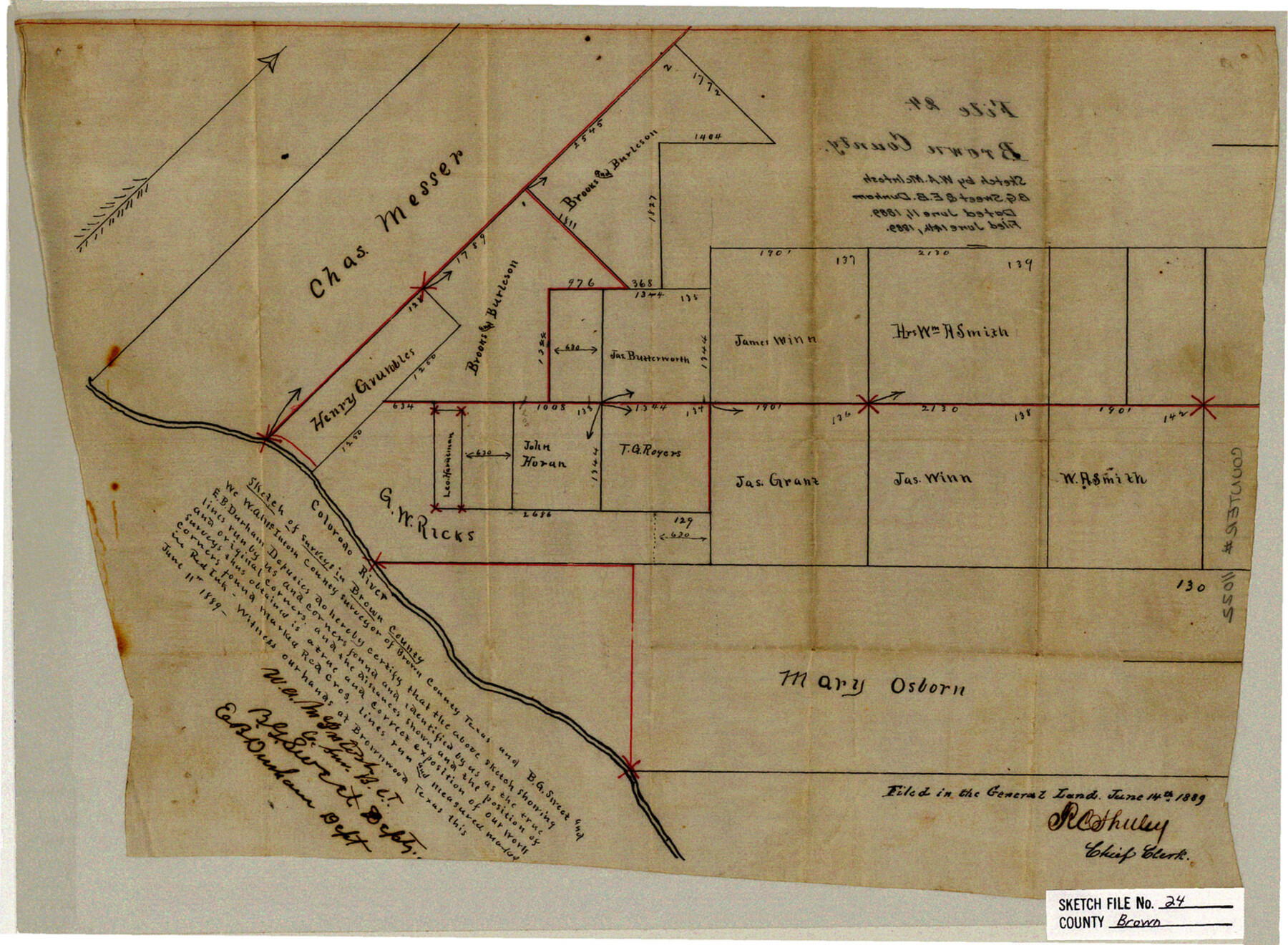
Brown County Sketch File 24
[Sketch of area in southwest corner of the county along and north of Colorado River]
-
Map/Doc
11022
-
Collection
General Map Collection
-
Object Dates
1889/6/11 (Creation Date)
1889/6/14 (File Date)
-
People and Organizations
E.B. Durham (Surveyor/Engineer)
W.A. McIntosh (Surveyor/Engineer)
B.G. Sweet (Surveyor/Engineer)
-
Counties
Brown
-
Subjects
Surveying Sketch File
-
Height x Width
11.7 x 15.9 inches
29.7 x 40.4 cm
-
Medium
paper, manuscript
-
Features
Colorado River
Part of: General Map Collection
Hood County Working Sketch 24

Print $20.00
- Digital $50.00
Hood County Working Sketch 24
1993
Size 36.2 x 37.4 inches
Map/Doc 66218
Throckmorton County

Print $20.00
- Digital $50.00
Throckmorton County
1943
Size 47.8 x 38.2 inches
Map/Doc 63065
Crockett County Working Sketch 74

Print $20.00
- Digital $50.00
Crockett County Working Sketch 74
1964
Size 29.4 x 22.1 inches
Map/Doc 68407
Hardin County Working Sketch 7

Print $20.00
- Digital $50.00
Hardin County Working Sketch 7
1925
Size 23.3 x 12.6 inches
Map/Doc 63405
Crane County Working Sketch 27

Print $40.00
- Digital $50.00
Crane County Working Sketch 27
1972
Size 71.9 x 47.1 inches
Map/Doc 68304
Pecos County Working Sketch 50

Print $20.00
- Digital $50.00
Pecos County Working Sketch 50
1947
Size 21.1 x 13.4 inches
Map/Doc 71522
Gaines County Rolled Sketch 24

Print $20.00
- Digital $50.00
Gaines County Rolled Sketch 24
1965
Size 41.8 x 31.3 inches
Map/Doc 9314
[Corpus Christi Bay, Padre Island, Mustang Island, Laguna de la Madre, King and Kenedy's Pasture]
![73047, [Corpus Christi Bay, Padre Island, Mustang Island, Laguna de la Madre, King and Kenedy's Pasture], General Map Collection](https://historictexasmaps.com/wmedia_w700/maps/73047.tif.jpg)
Print $20.00
- Digital $50.00
[Corpus Christi Bay, Padre Island, Mustang Island, Laguna de la Madre, King and Kenedy's Pasture]
Size 18.2 x 26.0 inches
Map/Doc 73047
Orange County Working Sketch 44

Print $20.00
- Digital $50.00
Orange County Working Sketch 44
1980
Size 16.5 x 22.0 inches
Map/Doc 71376
Bexar County State Real Property Sketch 2

Print $40.00
- Digital $50.00
Bexar County State Real Property Sketch 2
1997
Size 25.6 x 38.7 inches
Map/Doc 61701
Hale County Working Sketch 2

Print $20.00
- Digital $50.00
Hale County Working Sketch 2
1916
Size 13.5 x 13.1 inches
Map/Doc 63322
Donley County Sketch File B12

Print $6.00
- Digital $50.00
Donley County Sketch File B12
1982
Size 9.1 x 14.6 inches
Map/Doc 21276
You may also like
Howard County Sketch File 9

Print $20.00
- Digital $50.00
Howard County Sketch File 9
Size 19.4 x 15.9 inches
Map/Doc 11797
Blanco County Working Sketch 44

Print $20.00
- Digital $50.00
Blanco County Working Sketch 44
2000
Size 19.5 x 35.6 inches
Map/Doc 67404
Brewster County Rolled Sketch 157

Print $20.00
- Digital $50.00
Brewster County Rolled Sketch 157
2008
Size 36.6 x 24.8 inches
Map/Doc 88870
Nueces County Rolled Sketch 49

Print $20.00
- Digital $50.00
Nueces County Rolled Sketch 49
1941
Size 34.9 x 28.8 inches
Map/Doc 6889
The Peters Colony. November 9, 1841

Print $20.00
The Peters Colony. November 9, 1841
2020
Size 21.7 x 21.7 inches
Map/Doc 96363
Set of new maps of Austin's Colony by G. Borden, Jr.

Print $20.00
- Digital $50.00
Set of new maps of Austin's Colony by G. Borden, Jr.
1833
Size 25.0 x 17.0 inches
Map/Doc 131
Houston County Working Sketch 24

Print $40.00
- Digital $50.00
Houston County Working Sketch 24
1983
Size 43.9 x 77.2 inches
Map/Doc 66254
Newton County Working Sketch 25

Print $20.00
- Digital $50.00
Newton County Working Sketch 25
1953
Size 25.4 x 23.8 inches
Map/Doc 71271
Fort Bend County Rolled Sketch P

Print $20.00
- Digital $50.00
Fort Bend County Rolled Sketch P
Size 32.2 x 15.5 inches
Map/Doc 5906
Presidio County Sketch File 94

Print $6.00
- Digital $50.00
Presidio County Sketch File 94
1955
Size 14.2 x 8.8 inches
Map/Doc 34770

[Sketch for Mineral Application 16696-16697, Pecos River]
![76024, [Sketch for Mineral Application 16696-16697, Pecos River], General Map Collection](https://historictexasmaps.com/wmedia_w700/maps/76024.tif.jpg)
Print $40.00
- Digital $50.00
[Sketch for Mineral Application 16696-16697, Pecos River]
Size 44.0 x 126.6 inches
Map/Doc 76024