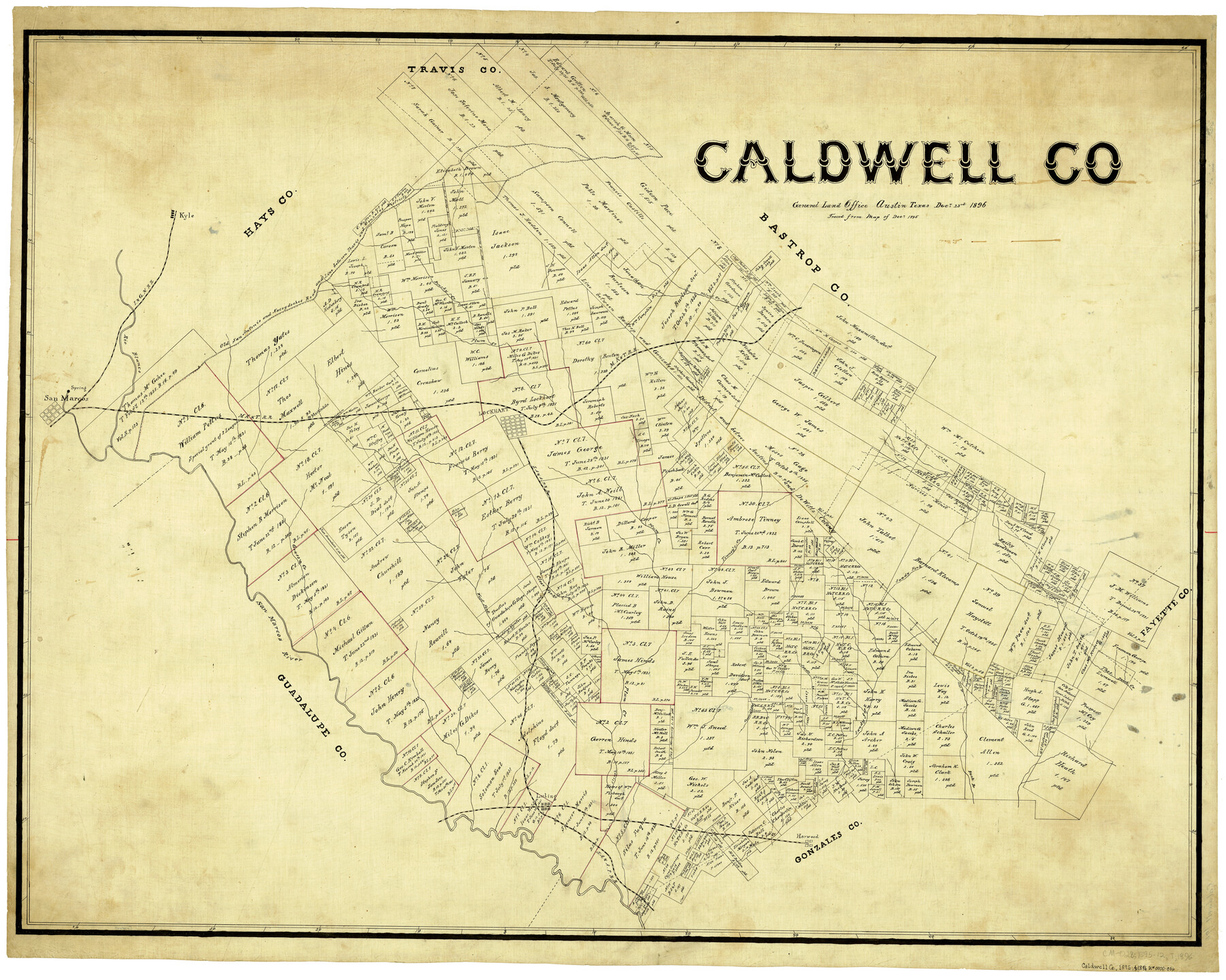
Caldwell Co.
-
Map/Doc
4898
-
Collection
General Map Collection
-
Object Dates
12/23/1896 (Creation Date)
-
Counties
Caldwell
-
Subjects
County
-
Height x Width
32.8 x 41.5 inches
83.3 x 105.4 cm
-
Comments
Traced from Map of December 1895.
Part of: General Map Collection
Map of The Surveyed Part of Peters Colony Texas

Print $40.00
- Digital $50.00
Map of The Surveyed Part of Peters Colony Texas
1858
Size 45.6 x 58.5 inches
Map/Doc 1982
Intracoastal Waterway in Texas - Corpus Christi to Point Isabel including Arroyo Colorado to Mo. Pac. R.R. Bridge Near Harlingen

Print $20.00
- Digital $50.00
Intracoastal Waterway in Texas - Corpus Christi to Point Isabel including Arroyo Colorado to Mo. Pac. R.R. Bridge Near Harlingen
1933
Size 27.7 x 40.8 inches
Map/Doc 61867
Dimmit County Working Sketch 17

Print $20.00
- Digital $50.00
Dimmit County Working Sketch 17
1943
Size 27.4 x 24.7 inches
Map/Doc 68678
Harris County Sketch File 46

Print $6.00
- Digital $50.00
Harris County Sketch File 46
1906
Size 8.8 x 13.7 inches
Map/Doc 25443
Bee County Working Sketch 8

Print $20.00
- Digital $50.00
Bee County Working Sketch 8
1939
Size 18.0 x 20.5 inches
Map/Doc 67258
Houston County Working Sketch 29

Print $20.00
- Digital $50.00
Houston County Working Sketch 29
1990
Size 23.4 x 23.1 inches
Map/Doc 66259
Map of Wise County

Print $20.00
- Digital $50.00
Map of Wise County
1895
Size 41.7 x 37.5 inches
Map/Doc 63133
Wise County Sketch File 41

Print $4.00
- Digital $50.00
Wise County Sketch File 41
1875
Size 12.8 x 8.1 inches
Map/Doc 40599
Rio Grande, Brownsville Sheet No. 1

Print $6.00
- Digital $50.00
Rio Grande, Brownsville Sheet No. 1
1924
Size 28.3 x 35.4 inches
Map/Doc 65130
Burnet County Sketch File 8

Print $22.00
- Digital $50.00
Burnet County Sketch File 8
Size 8.1 x 6.3 inches
Map/Doc 16689
Coryell County Working Sketch 31

Print $4.00
- Digital $50.00
Coryell County Working Sketch 31
2008
Size 21.8 x 20.6 inches
Map/Doc 88735
Hardin County Rolled Sketch 8

Print $20.00
- Digital $50.00
Hardin County Rolled Sketch 8
1947
Size 23.7 x 25.8 inches
Map/Doc 6081
You may also like
Castro County Rolled Sketch 11

Print $20.00
- Digital $50.00
Castro County Rolled Sketch 11
1940
Size 20.2 x 25.3 inches
Map/Doc 5420
Motley County Sketch File 2 (S)

Print $20.00
- Digital $50.00
Motley County Sketch File 2 (S)
Size 31.1 x 25.1 inches
Map/Doc 42133
Map of Eastland County, the portion on the waters of Colorado River, Travis - the balance, Milam Land District

Print $20.00
- Digital $50.00
Map of Eastland County, the portion on the waters of Colorado River, Travis - the balance, Milam Land District
1860
Size 23.8 x 21.5 inches
Map/Doc 3501
Flight Mission No. CUG-1P, Frame 171, Kleberg County

Print $20.00
- Digital $50.00
Flight Mission No. CUG-1P, Frame 171, Kleberg County
1956
Size 18.5 x 22.1 inches
Map/Doc 86178
Brewster County Working Sketch 48

Print $20.00
- Digital $50.00
Brewster County Working Sketch 48
1949
Size 28.9 x 23.7 inches
Map/Doc 67582
Angelina County Sketch File 17

Print $9.00
- Digital $50.00
Angelina County Sketch File 17
1863
Size 8.2 x 7.0 inches
Map/Doc 13020
Flight Mission No. DQN-3K, Frame 35, Calhoun County

Print $20.00
- Digital $50.00
Flight Mission No. DQN-3K, Frame 35, Calhoun County
1953
Size 16.4 x 16.2 inches
Map/Doc 84348
Young County Boundary File 98

Print $12.00
- Digital $50.00
Young County Boundary File 98
Size 8.8 x 7.5 inches
Map/Doc 60205
Gaines County Working Sketch 17

Print $20.00
- Digital $50.00
Gaines County Working Sketch 17
1964
Size 47.6 x 34.5 inches
Map/Doc 69317
Milam County Rolled Sketch 2

Print $20.00
- Digital $50.00
Milam County Rolled Sketch 2
1954
Size 21.9 x 24.8 inches
Map/Doc 6774
Culberson County Sketch File 40

Print $6.00
- Digital $50.00
Culberson County Sketch File 40
Size 24.8 x 35.2 inches
Map/Doc 11275
Schleicher County Sketch File 29

Print $44.00
- Digital $50.00
Schleicher County Sketch File 29
1940
Size 31.9 x 23.7 inches
Map/Doc 12306