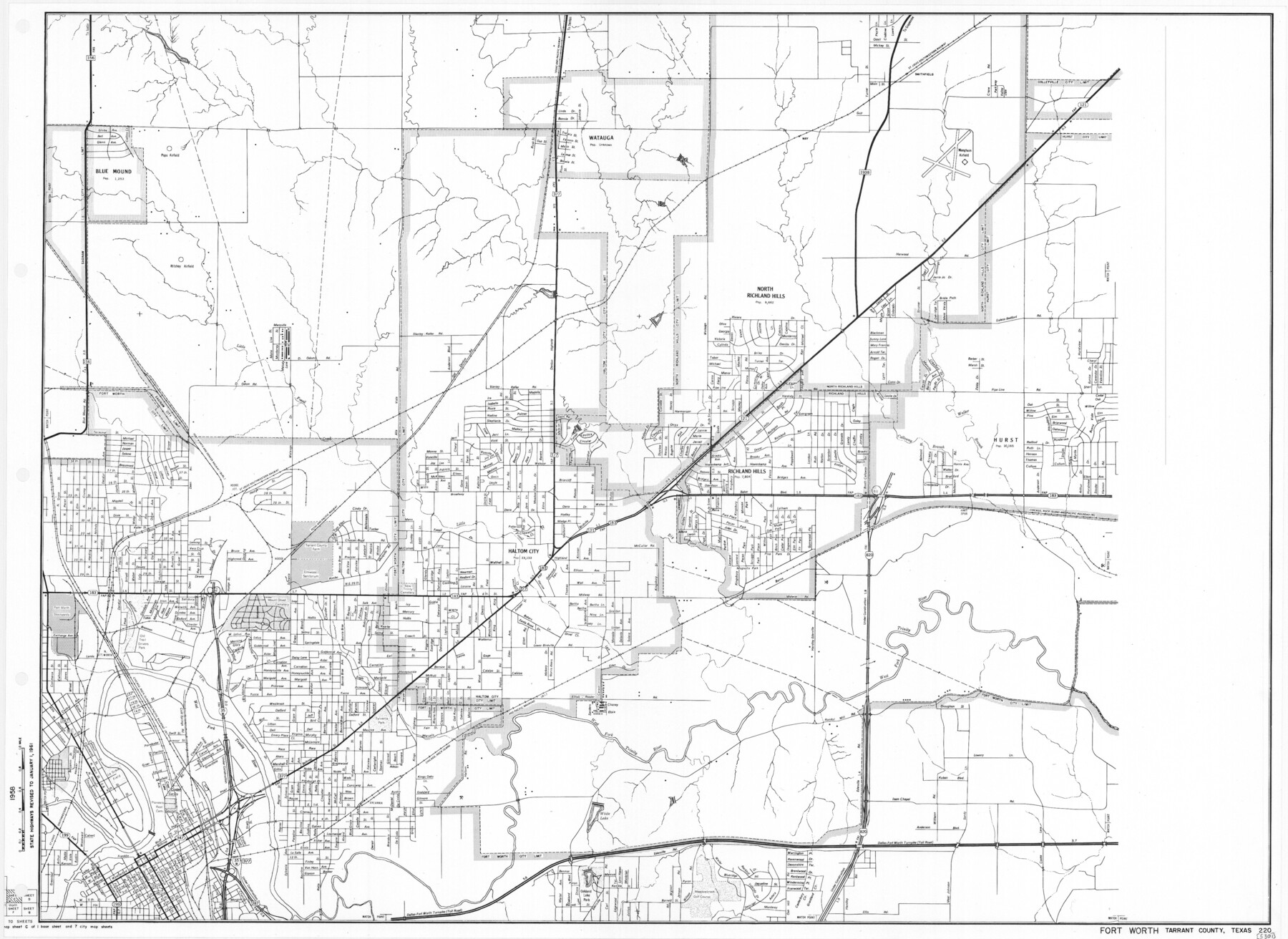
General Highway Map. Detail of Cities and Towns in Tarrant County, Texas. City Map, Fort Worth and vicinity, Tarrant County, Texas
-
Map/Doc
79667
-
Collection
Texas State Library and Archives
-
Object Dates
1961 (Creation Date)
-
People and Organizations
Texas State Highway Department (Publisher)
-
Counties
Tarrant
-
Subjects
City County
-
Height x Width
18.2 x 24.9 inches
46.2 x 63.3 cm
-
Comments
Prints available courtesy of the Texas State Library and Archives.
More info can be found here: TSLAC Map 05301
Part of: Texas State Library and Archives
General Highway Map, Winkler County, Texas

Print $20.00
General Highway Map, Winkler County, Texas
1961
Size 18.2 x 24.8 inches
Map/Doc 79717
General Highway Map. Detail of Cities and Towns in Tarrant County, Texas. City Map, Fort Worth and vicinity, Tarrant County, Texas

Print $20.00
General Highway Map. Detail of Cities and Towns in Tarrant County, Texas. City Map, Fort Worth and vicinity, Tarrant County, Texas
1961
Size 18.1 x 25.0 inches
Map/Doc 79665
General Highway Map. Detail of Cities and Towns in Leon County, Texas

Print $20.00
General Highway Map. Detail of Cities and Towns in Leon County, Texas
1961
Size 18.1 x 24.8 inches
Map/Doc 79569
General Highway Map. Detail of Cities and Towns in Nacogdoches County, Texas

Print $20.00
General Highway Map. Detail of Cities and Towns in Nacogdoches County, Texas
1961
Size 19.3 x 25.0 inches
Map/Doc 79608
Map of Texas compiled from surveys recorded in the Land Office of Texas, and other official surveys

Print $20.00
Map of Texas compiled from surveys recorded in the Land Office of Texas, and other official surveys
1841
Size 25.1 x 20.4 inches
Map/Doc 76253
Plan of the City of Austin

Print $20.00
Plan of the City of Austin
1853
Size 13.9 x 11.5 inches
Map/Doc 76207
General Highway Map, Bexar County, Texas

Print $20.00
General Highway Map, Bexar County, Texas
1940
Size 18.3 x 25.1 inches
Map/Doc 79017
General Highway Map. Detail of Cities and Towns in Harris County, Texas

Print $20.00
General Highway Map. Detail of Cities and Towns in Harris County, Texas
1961
Size 18.2 x 24.6 inches
Map/Doc 79503
Map of the United States and their Territories between the Mississippi and the Pacific Ocean and Part of Mexico

Print $20.00
Map of the United States and their Territories between the Mississippi and the Pacific Ocean and Part of Mexico
1857
Size 21.8 x 24.7 inches
Map/Doc 79724
General Highway Map, Jefferson County, Texas

Print $20.00
General Highway Map, Jefferson County, Texas
1961
Size 24.6 x 18.3 inches
Map/Doc 79537
General Highway Map, Fort Bend County, Texas

Print $20.00
General Highway Map, Fort Bend County, Texas
1939
Size 18.6 x 25.2 inches
Map/Doc 79093
Preliminary Chart No. 31 of the Sea Coast of the United States from Galveston Bay to Matagorda Bay, Texas

Print $20.00
Preliminary Chart No. 31 of the Sea Coast of the United States from Galveston Bay to Matagorda Bay, Texas
1857
Size 21.6 x 37.2 inches
Map/Doc 76212
You may also like
Duval County Sketch File 83

Print $20.00
- Digital $50.00
Duval County Sketch File 83
1933
Size 13.7 x 8.8 inches
Map/Doc 21521
Presidio County Rolled Sketch 119

Print $20.00
- Digital $50.00
Presidio County Rolled Sketch 119
1982
Size 30.6 x 27.2 inches
Map/Doc 7394
[T. & P. Blocks 43-45, Townships 1S and 1N]
![90878, [T. & P. Blocks 43-45, Townships 1S and 1N], Twichell Survey Records](https://historictexasmaps.com/wmedia_w700/maps/90878-2.tif.jpg)
Print $20.00
- Digital $50.00
[T. & P. Blocks 43-45, Townships 1S and 1N]
Size 22.9 x 18.0 inches
Map/Doc 90878
Wharton County

Print $20.00
- Digital $50.00
Wharton County
1877
Size 24.6 x 26.7 inches
Map/Doc 4133
[Surveys near Crabapple Creek in the Bexar District]
![87, [Surveys near Crabapple Creek in the Bexar District], General Map Collection](https://historictexasmaps.com/wmedia_w700/maps/87.tif.jpg)
Print $2.00
- Digital $50.00
[Surveys near Crabapple Creek in the Bexar District]
1846
Size 9.1 x 7.0 inches
Map/Doc 87
Panola County Rolled Sketch 5

Print $40.00
- Digital $50.00
Panola County Rolled Sketch 5
Size 81.0 x 33.1 inches
Map/Doc 9678
Flight Mission No. CGI-3G, Frame 12, Cameron County

Print $20.00
- Digital $50.00
Flight Mission No. CGI-3G, Frame 12, Cameron County
1950
Size 19.3 x 19.0 inches
Map/Doc 84531
Flight Mission No. BRA-16M, Frame 148, Jefferson County

Print $20.00
- Digital $50.00
Flight Mission No. BRA-16M, Frame 148, Jefferson County
1953
Size 18.5 x 22.2 inches
Map/Doc 85754
La Salle County Rolled Sketch 13

Print $20.00
- Digital $50.00
La Salle County Rolled Sketch 13
1948
Size 28.7 x 34.2 inches
Map/Doc 6576
Harris County Rolled Sketch P3

Print $20.00
- Digital $50.00
Harris County Rolled Sketch P3
1933
Size 13.9 x 20.0 inches
Map/Doc 6142
Menard County Sketch File 27

Print $8.00
- Digital $50.00
Menard County Sketch File 27
1943
Size 11.2 x 8.8 inches
Map/Doc 31564
Fannin County Rolled Sketch 18E

Print $2.00
- Digital $50.00
Fannin County Rolled Sketch 18E
Size 9.5 x 8.2 inches
Map/Doc 5872