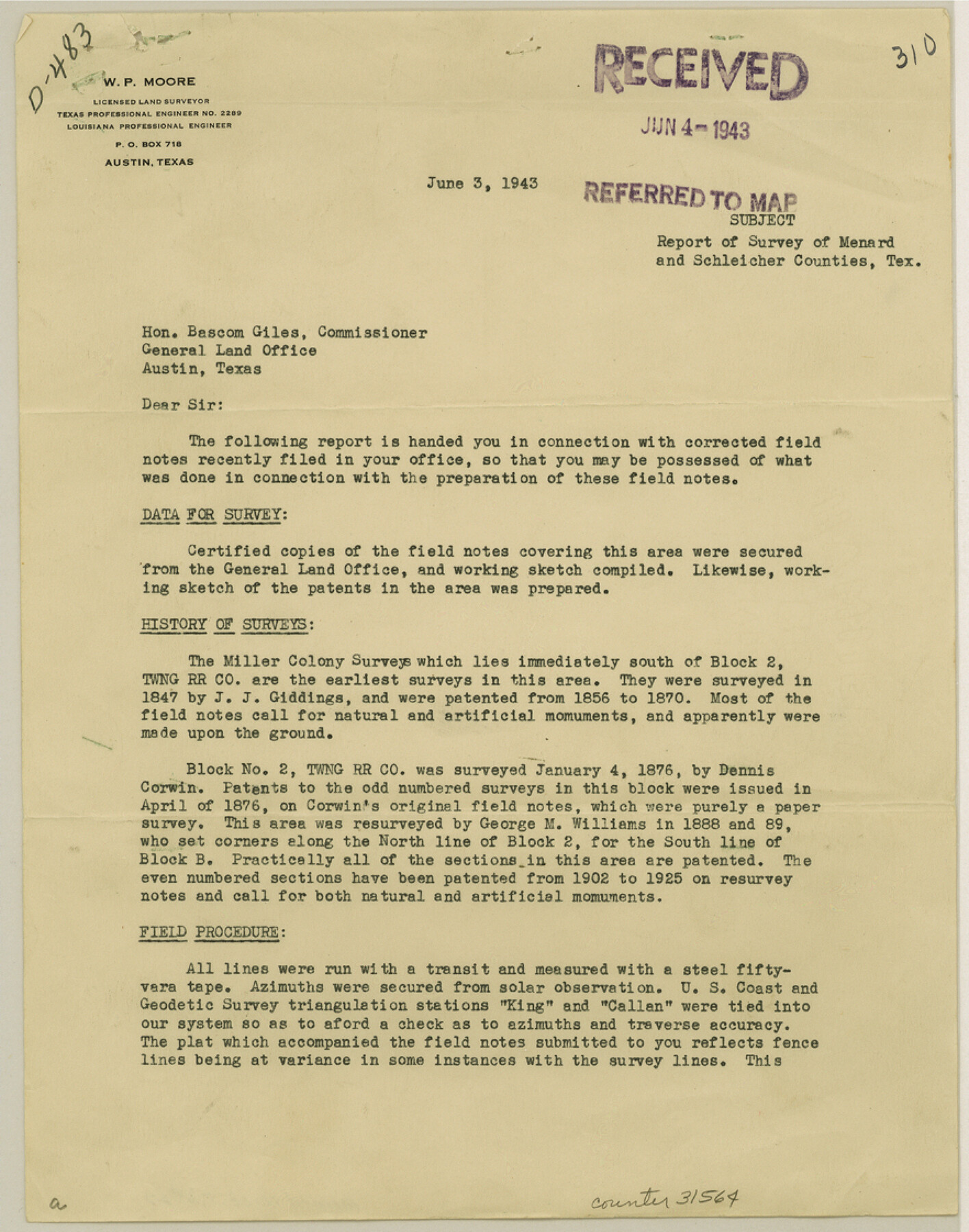
Menard County Sketch File 27
[Surveyor's report of surveys in G. H. & S. A. Block B and T. W. N. G. Block 2]
-
Map/Doc
31564
-
Collection
General Map Collection
-
Object Dates
6/3/1943 (Creation Date)
6/10/1943 (File Date)
6/3/1943 (Correspondence Date)
6/5/1943 (Correspondence Date)
-
People and Organizations
W.P. Moore (Surveyor/Engineer)
J.J. Giddings (Surveyor/Engineer)
George M. Williams (Surveyor/Engineer)
D.H. Clark (Surveyor/Engineer)
D.W. Maddox (Surveyor/Engineer)
-
Counties
Menard Schleicher
-
Subjects
Surveying Sketch File
-
Height x Width
11.2 x 8.8 inches
28.5 x 22.4 cm
-
Medium
paper, print
-
Comments
See Menard County Rolled Sketch 7 (9509) for sketch.
-
Features
San Saba River
Related maps
Menard County Rolled Sketch 7

Print $20.00
- Digital $50.00
Menard County Rolled Sketch 7
Size 43.2 x 37.3 inches
Map/Doc 9509
Part of: General Map Collection
Menard County Sketch File 10

Print $20.00
- Digital $50.00
Menard County Sketch File 10
1885
Size 32.5 x 18.0 inches
Map/Doc 12074
Travis County Rolled Sketch 29

Print $20.00
- Digital $50.00
Travis County Rolled Sketch 29
1946
Size 25.1 x 37.8 inches
Map/Doc 8031
Freestone County Sketch File 25

Print $18.00
- Digital $50.00
Freestone County Sketch File 25
1952
Size 11.3 x 8.6 inches
Map/Doc 23087
Flight Mission No. DQN-2K, Frame 196, Calhoun County

Print $20.00
- Digital $50.00
Flight Mission No. DQN-2K, Frame 196, Calhoun County
1953
Size 16.3 x 16.1 inches
Map/Doc 84335
Flight Mission No. CRE-2R, Frame 82, Jackson County

Print $20.00
- Digital $50.00
Flight Mission No. CRE-2R, Frame 82, Jackson County
1956
Size 16.0 x 15.9 inches
Map/Doc 85354
Williamson County Sketch File 24

Print $12.00
- Digital $50.00
Williamson County Sketch File 24
1877
Size 12.8 x 8.1 inches
Map/Doc 40355
Potter County Working Sketch 11

Print $20.00
- Digital $50.00
Potter County Working Sketch 11
1972
Size 27.4 x 26.4 inches
Map/Doc 71671
Kerr County Sketch File 1d

Print $6.00
- Digital $50.00
Kerr County Sketch File 1d
1856
Size 8.1 x 7.6 inches
Map/Doc 28853
Houston County Working Sketch 32

Print $20.00
- Digital $50.00
Houston County Working Sketch 32
1987
Size 43.9 x 33.0 inches
Map/Doc 66262
Starr County Rolled Sketch 39

Print $20.00
- Digital $50.00
Starr County Rolled Sketch 39
1954
Size 24.9 x 27.7 inches
Map/Doc 7833
[Right of Way Map, Belton Branch of the M.K.&T. RR.]
![64222, [Right of Way Map, Belton Branch of the M.K.&T. RR.], General Map Collection](https://historictexasmaps.com/wmedia_w700/maps/64222.tif.jpg)
Print $20.00
- Digital $50.00
[Right of Way Map, Belton Branch of the M.K.&T. RR.]
1896
Size 21.9 x 7.4 inches
Map/Doc 64222
Rand, McNally and Co.'s Texas and Indian Territory

Print $20.00
- Digital $50.00
Rand, McNally and Co.'s Texas and Indian Territory
1883
Size 24.3 x 18.6 inches
Map/Doc 4331
You may also like
Harris County Rolled Sketch 88

Print $20.00
- Digital $50.00
Harris County Rolled Sketch 88
1936
Size 34.6 x 22.8 inches
Map/Doc 6124
Bee County Sketch File 5

Print $40.00
- Digital $50.00
Bee County Sketch File 5
Size 27.4 x 23.4 inches
Map/Doc 10914
Flight Mission No. DJV-3P, Frame 13, Ellis County

Print $20.00
- Digital $50.00
Flight Mission No. DJV-3P, Frame 13, Ellis County
1956
Size 18.6 x 22.2 inches
Map/Doc 84975
[Map of Hidalgo County]
![6207, [Map of Hidalgo County], General Map Collection](https://historictexasmaps.com/wmedia_w700/maps/6207.tif.jpg)
Print $20.00
- Digital $50.00
[Map of Hidalgo County]
1882
Size 26.0 x 19.9 inches
Map/Doc 6207
State Tracts in East Part of Corpus Christi Bay, surveys on Harbor Island and Corpus Christi Channel, Nueces County

Print $40.00
- Digital $50.00
State Tracts in East Part of Corpus Christi Bay, surveys on Harbor Island and Corpus Christi Channel, Nueces County
1957
Size 54.1 x 37.7 inches
Map/Doc 1919
Hall County Working Sketch 6

Print $20.00
- Digital $50.00
Hall County Working Sketch 6
1954
Size 21.8 x 21.6 inches
Map/Doc 63334
Morris County Rolled Sketch 2A

Print $20.00
- Digital $50.00
Morris County Rolled Sketch 2A
Size 24.0 x 18.7 inches
Map/Doc 10280
[Section 34, Block 194 G. C. & S. F.]
![91671, [Section 34, Block 194 G. C. & S. F.], Twichell Survey Records](https://historictexasmaps.com/wmedia_w700/maps/91671-1.tif.jpg)
Print $2.00
- Digital $50.00
[Section 34, Block 194 G. C. & S. F.]
1927
Size 7.6 x 5.9 inches
Map/Doc 91671
Flight Mission No. DQN-2K, Frame 10, Calhoun County

Print $20.00
- Digital $50.00
Flight Mission No. DQN-2K, Frame 10, Calhoun County
1953
Size 18.5 x 22.0 inches
Map/Doc 84227
Refugio County NRC Article 33.136 Location Key Sheet

Print $20.00
- Digital $50.00
Refugio County NRC Article 33.136 Location Key Sheet
1979
Size 27.0 x 23.0 inches
Map/Doc 77034
Harris County Working Sketch 38

Print $20.00
- Digital $50.00
Harris County Working Sketch 38
1938
Size 23.6 x 23.7 inches
Map/Doc 65930
