Presidio County Rolled Sketch 119
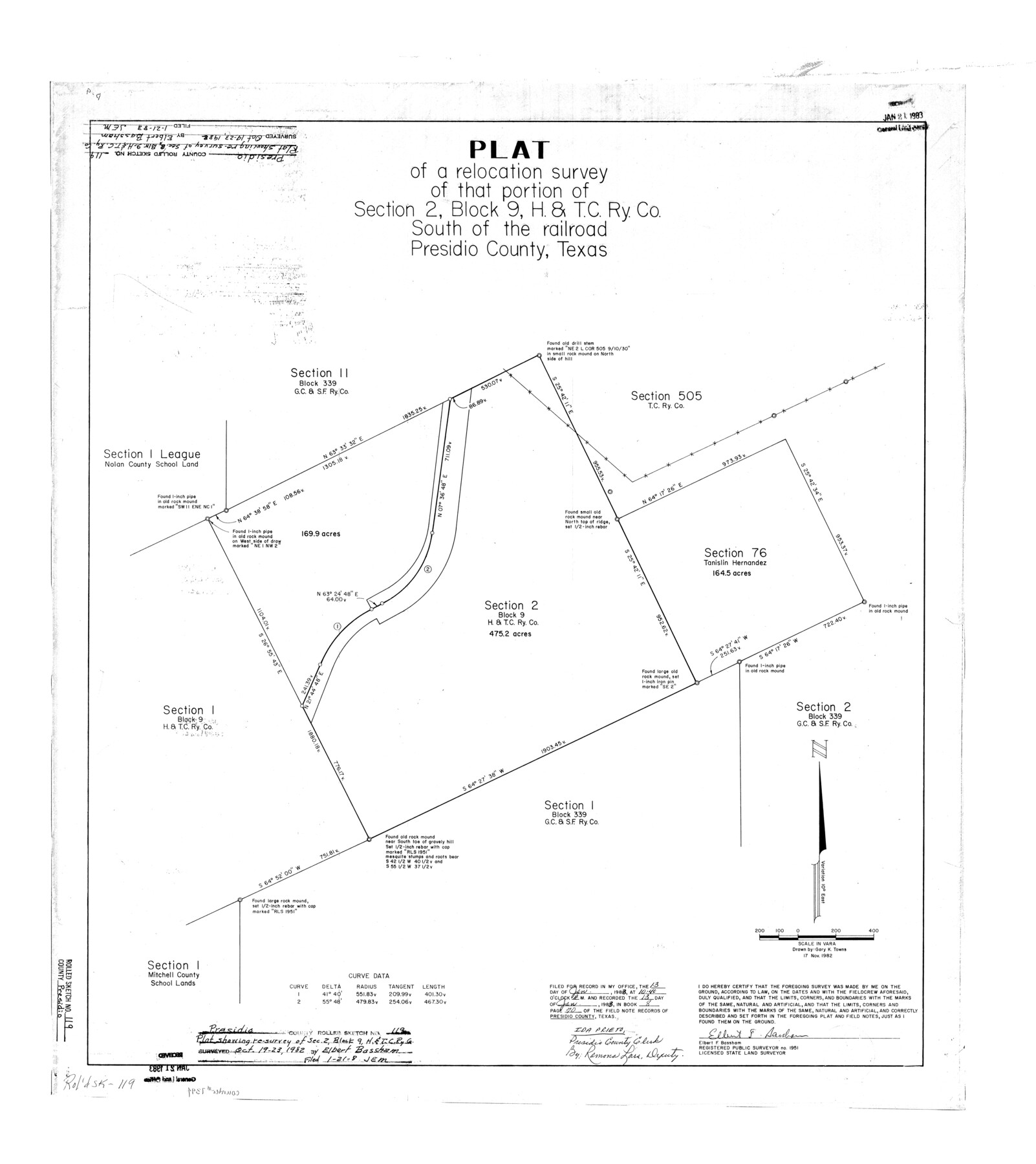
Plat of a relocation survey of that portion of section 2, Block 9, H. & T. C. Ry. Co. south of the railroad, Presidio County, Texas
-
Map/Doc
7394
-
Collection
General Map Collection
-
Object Dates
1982/10/23 (Survey Date)
1983/1/21 (File Date)
1982/11/17 (Creation Date)
-
People and Organizations
Elbert F. Bassham (Surveyor/Engineer)
Gary K. Towns (Draftsman)
-
Counties
Presidio
-
Subjects
Surveying Rolled Sketch
-
Height x Width
30.6 x 27.2 inches
77.7 x 69.1 cm
-
Medium
mylar, print
Part of: General Map Collection

Crosby County Sketch File 20

Print $20.00
- Digital $50.00
Crosby County Sketch File 20
Size 25.9 x 18.3 inches
Map/Doc 11252
Newton County Sketch File 5

Print $8.00
- Digital $50.00
Newton County Sketch File 5
Size 8.2 x 12.8 inches
Map/Doc 32368
San Augustine County Sketch File 23

Print $12.00
San Augustine County Sketch File 23
1992
Size 14.5 x 9.0 inches
Map/Doc 35689
Intracoastal Waterway in Texas - Corpus Christi to Point Isabel including Arroyo Colorado to Mo. Pac. R.R. Bridge Near Harlingen

Print $20.00
- Digital $50.00
Intracoastal Waterway in Texas - Corpus Christi to Point Isabel including Arroyo Colorado to Mo. Pac. R.R. Bridge Near Harlingen
1934
Size 21.8 x 32.7 inches
Map/Doc 61885
Marion County Working Sketch 29

Print $20.00
- Digital $50.00
Marion County Working Sketch 29
1977
Size 20.4 x 16.1 inches
Map/Doc 70805
Sutton County Working Sketch 11

Print $40.00
- Digital $50.00
Sutton County Working Sketch 11
1972
Size 76.8 x 45.5 inches
Map/Doc 62354
McMullen County

Print $40.00
- Digital $50.00
McMullen County
1967
Size 50.8 x 35.8 inches
Map/Doc 95586
Briscoe County Sketch File 10

Print $4.00
- Digital $50.00
Briscoe County Sketch File 10
1901
Size 11.2 x 8.7 inches
Map/Doc 16420
Jefferson County NRC Article 33.136 Sketch 13

Print $164.00
- Digital $50.00
Jefferson County NRC Article 33.136 Sketch 13
2019
Size 22.2 x 35.0 inches
Map/Doc 96447
No. 3 Chart of Channel connecting Corpus Christi Bay with Aransas Bay, Texas

Print $20.00
- Digital $50.00
No. 3 Chart of Channel connecting Corpus Christi Bay with Aransas Bay, Texas
1878
Size 18.3 x 28.0 inches
Map/Doc 72773
Gonzales County Rolled Sketch 3

Print $20.00
- Digital $50.00
Gonzales County Rolled Sketch 3
2021
Size 24.4 x 35.6 inches
Map/Doc 96582
You may also like
Sectional map of Texas traversed by the Missouri, Kansas & Texas Railway, showing the crops adapted to each section, with the elevation and annual rainfall

Print $20.00
- Digital $50.00
Sectional map of Texas traversed by the Missouri, Kansas & Texas Railway, showing the crops adapted to each section, with the elevation and annual rainfall
1904
Size 21.7 x 22.6 inches
Map/Doc 95814
Cherokee County Sketch File 14

Print $4.00
- Digital $50.00
Cherokee County Sketch File 14
1860
Size 8.0 x 5.9 inches
Map/Doc 18147
Denton County Working Sketch 16

Print $20.00
- Digital $50.00
Denton County Working Sketch 16
1973
Size 31.5 x 39.1 inches
Map/Doc 68621
Zavala County Sketch File A1

Print $31.00
- Digital $50.00
Zavala County Sketch File A1
1899
Size 23.5 x 28.6 inches
Map/Doc 12735
[R. T. Bucy's Survey 3, League 321]
![91348, [R. T. Bucy's Survey 3, League 321], Twichell Survey Records](https://historictexasmaps.com/wmedia_w700/maps/91348.tif.jpg)
Digital $50.00
[R. T. Bucy's Survey 3, League 321]
Map/Doc 91348
Brazoria County Working Sketch 19

Print $40.00
- Digital $50.00
Brazoria County Working Sketch 19
1951
Size 50.3 x 42.3 inches
Map/Doc 67504
Kimble County Working Sketch 16

Print $20.00
- Digital $50.00
Kimble County Working Sketch 16
1923
Size 22.9 x 17.1 inches
Map/Doc 70084
Real County Sketch File 19

Print $22.00
- Digital $50.00
Real County Sketch File 19
1967
Size 11.5 x 9.0 inches
Map/Doc 35080
Presidio County Rolled Sketch 122

Print $20.00
- Digital $50.00
Presidio County Rolled Sketch 122
1981
Size 33.9 x 28.3 inches
Map/Doc 7395
Flight Mission No. DIX-8P, Frame 61, Aransas County

Print $20.00
- Digital $50.00
Flight Mission No. DIX-8P, Frame 61, Aransas County
1956
Size 18.8 x 22.6 inches
Map/Doc 83892
Montgomery County Sketch File 2

Print $8.00
- Digital $50.00
Montgomery County Sketch File 2
1846
Size 12.7 x 8.0 inches
Map/Doc 31764
Childress County Rolled Sketch 8B

Print $20.00
- Digital $50.00
Childress County Rolled Sketch 8B
Size 13.3 x 18.8 inches
Map/Doc 5444