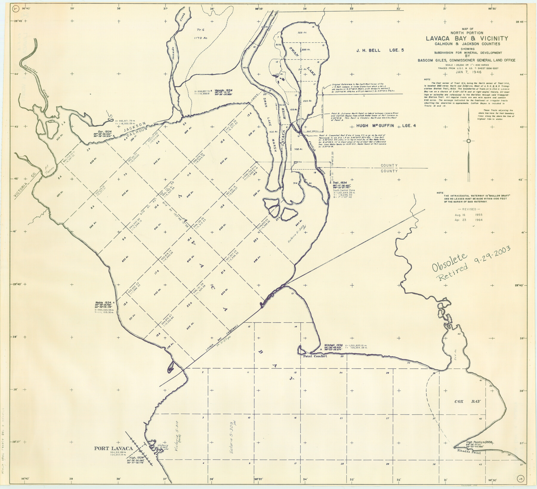
North Portion of Lavaca Bay and Vicinity, showing Subdivision for Mineral Development
Map of North Portion of Lavaca Bay & Vicinity
-
Map/Doc
1911
-
Collection
General Map Collection
-
Object Dates
1946 (Creation Date)
-
People and Organizations
General Land Office (Publisher)
-
Subjects
Energy Offshore Submerged Area
-
Height x Width
33.8 x 37.1 inches
85.9 x 94.2 cm
-
Medium
blueline cloth
-
Scale
600 varas
-
Comments
Gulf coast and submerged state lands. Revised April 23, 1964
Part of: General Map Collection
Andrews County Rolled Sketch 21

Print $20.00
- Digital $50.00
Andrews County Rolled Sketch 21
Size 18.2 x 26.3 inches
Map/Doc 77169

Sutton County Sketch File 58

Print $9.00
- Digital $50.00
Sutton County Sketch File 58
1964
Size 15.7 x 9.9 inches
Map/Doc 37554
Texas Gulf Coast Map from the Sabine River to the Rio Grande as subdivided for mineral development

Print $40.00
- Digital $50.00
Texas Gulf Coast Map from the Sabine River to the Rio Grande as subdivided for mineral development
1948
Size 49.3 x 55.7 inches
Map/Doc 2906
Reeves County Rolled Sketch 22

Print $20.00
- Digital $50.00
Reeves County Rolled Sketch 22
1960
Size 40.8 x 20.9 inches
Map/Doc 7490
Hudspeth County Sketch File 33

Print $6.00
- Digital $50.00
Hudspeth County Sketch File 33
1952
Size 11.3 x 8.8 inches
Map/Doc 26994
Travis County Working Sketch 42

Print $20.00
- Digital $50.00
Travis County Working Sketch 42
1974
Size 32.5 x 35.2 inches
Map/Doc 69426
Webb County Sketch File 2

Print $20.00
- Digital $50.00
Webb County Sketch File 2
Size 20.0 x 18.2 inches
Map/Doc 12612
Floyd County Sketch File 9

Print $20.00
- Digital $50.00
Floyd County Sketch File 9
1901
Size 22.1 x 15.3 inches
Map/Doc 11484
Menard County Sketch File 1

Print $4.00
- Digital $50.00
Menard County Sketch File 1
1859
Size 9.8 x 8.5 inches
Map/Doc 31484
Flight Mission No. DAG-21K, Frame 97, Matagorda County

Print $20.00
- Digital $50.00
Flight Mission No. DAG-21K, Frame 97, Matagorda County
1952
Size 18.4 x 22.2 inches
Map/Doc 86426
Nueces County Sketch File 75

Print $20.00
- Digital $50.00
Nueces County Sketch File 75
1977
Size 26.1 x 27.8 inches
Map/Doc 42199
You may also like
Williamson County

Print $20.00
- Digital $50.00
Williamson County
1919
Size 22.5 x 29.8 inches
Map/Doc 4643
Wichita County Working Sketch 13

Print $20.00
- Digital $50.00
Wichita County Working Sketch 13
1921
Size 16.5 x 32.8 inches
Map/Doc 72523
San Saba County Sketch File 8

Print $6.00
- Digital $50.00
San Saba County Sketch File 8
Size 6.6 x 7.9 inches
Map/Doc 36430
Amistad International Reservoir on Rio Grande 94

Print $20.00
- Digital $50.00
Amistad International Reservoir on Rio Grande 94
1950
Size 28.6 x 41.0 inches
Map/Doc 75524
Dickens County Sketch File H2

Print $2.00
- Digital $50.00
Dickens County Sketch File H2
Size 12.9 x 8.2 inches
Map/Doc 20874
Palo Pinto County Sketch File 6a

Print $20.00
- Digital $50.00
Palo Pinto County Sketch File 6a
Size 37.8 x 38.6 inches
Map/Doc 10565
La Salle County Working Sketch 25

Print $20.00
- Digital $50.00
La Salle County Working Sketch 25
1947
Size 32.8 x 41.0 inches
Map/Doc 70326
Flight Mission No. CGI-3N, Frame 121, Cameron County

Print $20.00
- Digital $50.00
Flight Mission No. CGI-3N, Frame 121, Cameron County
1954
Size 18.5 x 22.3 inches
Map/Doc 84594
[Surveys along the Guadalupe River and Blanco Creek]
![45, [Surveys along the Guadalupe River and Blanco Creek], General Map Collection](https://historictexasmaps.com/wmedia_w700/maps/45.tif.jpg)
Print $20.00
- Digital $50.00
[Surveys along the Guadalupe River and Blanco Creek]
Size 19.5 x 15.7 inches
Map/Doc 45
South Part Crockett County

Print $20.00
- Digital $50.00
South Part Crockett County
1977
Size 30.6 x 40.1 inches
Map/Doc 77254
Sulphur River, Talco Sheet

Print $20.00
- Digital $50.00
Sulphur River, Talco Sheet
1917
Size 12.5 x 25.5 inches
Map/Doc 78336
Map of Goliad County Texas

Print $20.00
- Digital $50.00
Map of Goliad County Texas
1879
Size 19.1 x 21.2 inches
Map/Doc 3589