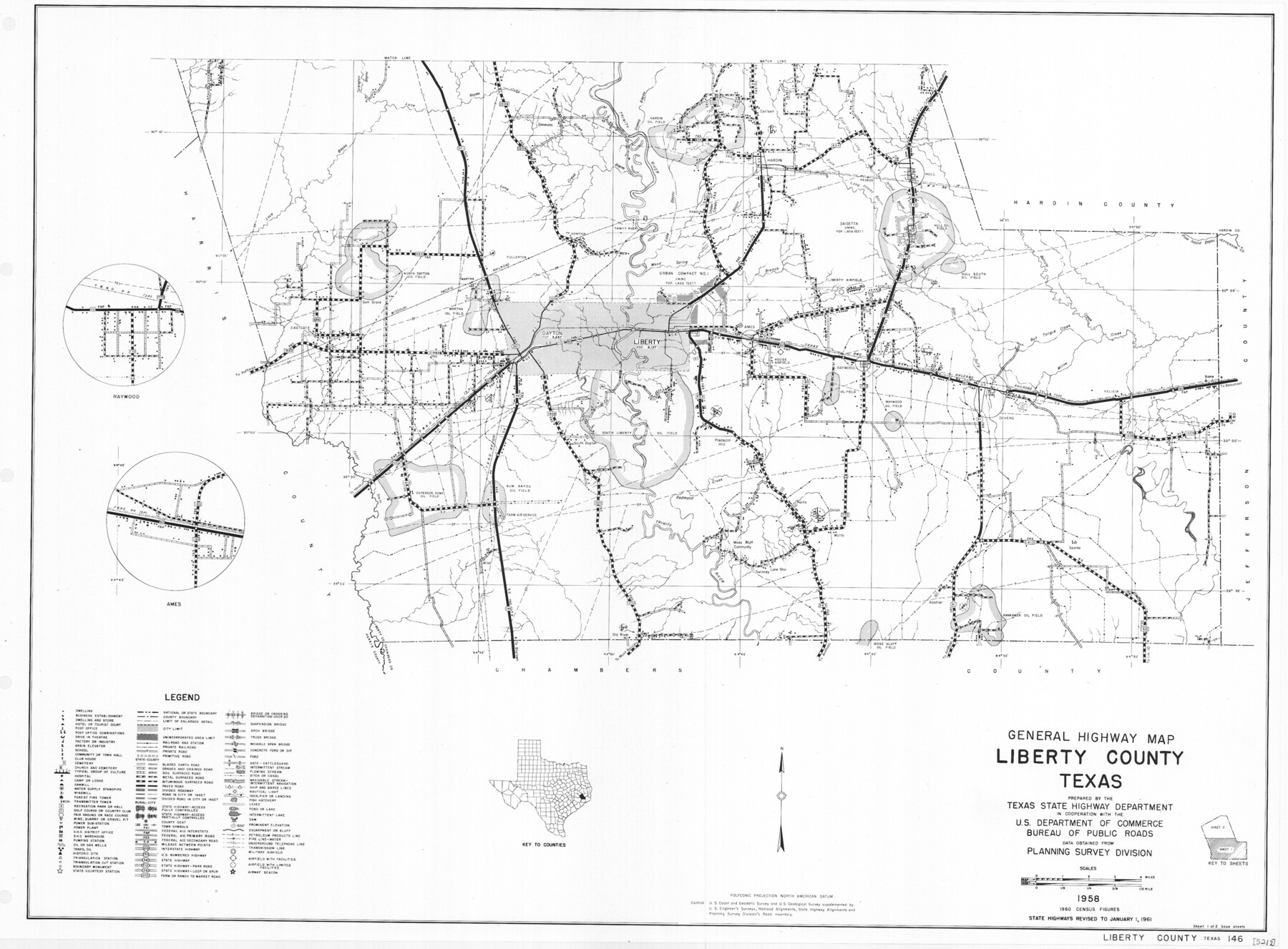
General Highway Map, Liberty County, Texas
-
Map/Doc
79570
-
Collection
Texas State Library and Archives
-
Object Dates
1961 (Creation Date)
-
People and Organizations
Texas State Highway Department (Publisher)
-
Counties
Liberty
-
Subjects
County
-
Height x Width
18.2 x 24.7 inches
46.2 x 62.7 cm
-
Comments
Prints available courtesy of the Texas State Library and Archives.
More info can be found here: TSLAC Map 05217
Part of: Texas State Library and Archives
General Highway Map, Harris County, Texas

Print $20.00
General Highway Map, Harris County, Texas
1961
Size 24.9 x 18.0 inches
Map/Doc 79502
Map of the City of Galveston, situated on the East End of Galveston Island, Texas

Print $20.00
Map of the City of Galveston, situated on the East End of Galveston Island, Texas
1869
Size 33.3 x 46.6 inches
Map/Doc 76186

General Highway Map, El Paso County, Texas

Print $20.00
General Highway Map, El Paso County, Texas
1940
Size 18.4 x 24.7 inches
Map/Doc 79084
General Highway Map, Jack County, Texas

Print $20.00
General Highway Map, Jack County, Texas
1940
Size 18.4 x 24.8 inches
Map/Doc 79139
General Highway Map, Houston County, Texas

Print $20.00
General Highway Map, Houston County, Texas
1961
Size 24.6 x 18.3 inches
Map/Doc 79524
General Highway Map. Detail of Cities and Towns in Harris County, Texas. City Map [of] Baytown, Morgan's Point, Lomax, and vicinity, Harris County, Texas
![79508, General Highway Map. Detail of Cities and Towns in Harris County, Texas. City Map [of] Baytown, Morgan's Point, Lomax, and vicinity, Harris County, Texas, Texas State Library and Archives](https://historictexasmaps.com/wmedia_w700/maps/79508.tif.jpg)
Print $20.00
General Highway Map. Detail of Cities and Towns in Harris County, Texas. City Map [of] Baytown, Morgan's Point, Lomax, and vicinity, Harris County, Texas
1961
Size 18.2 x 24.5 inches
Map/Doc 79508
General Highway Map, Willacy County, Texas

Print $20.00
General Highway Map, Willacy County, Texas
1940
Size 18.5 x 24.8 inches
Map/Doc 79279
Carte Reduite des Costes de la Louisiane et de la Floride

Print $20.00
Carte Reduite des Costes de la Louisiane et de la Floride
1764
Size 23.3 x 35.1 inches
Map/Doc 79295
General Highway Map, Jasper County, Newton County, Texas

Print $20.00
General Highway Map, Jasper County, Newton County, Texas
1940
Size 18.6 x 25.2 inches
Map/Doc 79142
General Highway Map, Burnet County, Texas

Print $20.00
General Highway Map, Burnet County, Texas
1961
Size 18.2 x 24.5 inches
Map/Doc 79393
General Highway Map, Jasper County, Newton County, Texas

Print $20.00
General Highway Map, Jasper County, Newton County, Texas
1940
Size 18.6 x 25.0 inches
Map/Doc 79141
You may also like
Baylor County Sketch File 23

Print $60.00
- Digital $50.00
Baylor County Sketch File 23
1927
Size 25.2 x 48.9 inches
Map/Doc 10324
Right of Way and Track Map, the Missouri, Kansas & Texas Ry. Of Texas operated by the Missouri, Kansas & Texas Ry. Of Texas, Houston Division

Print $40.00
- Digital $50.00
Right of Way and Track Map, the Missouri, Kansas & Texas Ry. Of Texas operated by the Missouri, Kansas & Texas Ry. Of Texas, Houston Division
1918
Size 25.5 x 61.9 inches
Map/Doc 64567
Burnet County Rolled Sketch T

Print $20.00
- Digital $50.00
Burnet County Rolled Sketch T
Size 24.7 x 18.3 inches
Map/Doc 5359
Hamilton County Rolled Sketch 12

Print $20.00
- Digital $50.00
Hamilton County Rolled Sketch 12
1981
Size 35.2 x 28.7 inches
Map/Doc 6061
Bexar County Sketch File 36c

Print $20.00
- Digital $50.00
Bexar County Sketch File 36c
1874
Size 19.3 x 26.4 inches
Map/Doc 10922
Wichita County Sketch File 19a

Print $20.00
- Digital $50.00
Wichita County Sketch File 19a
1892
Size 27.0 x 21.7 inches
Map/Doc 12682
Cherokee County

Print $40.00
- Digital $50.00
Cherokee County
1933
Size 57.0 x 38.8 inches
Map/Doc 77236
Galveston County Sketch File 59

Print $8.00
- Digital $50.00
Galveston County Sketch File 59
1977
Size 14.2 x 8.7 inches
Map/Doc 23607
Gulf Oil Corp. Fishgide - Freeport

Gulf Oil Corp. Fishgide - Freeport
1960
Size 12.3 x 22.4 inches
Map/Doc 75978
Flight Mission No. DQO-2K, Frame 136, Galveston County

Print $20.00
- Digital $50.00
Flight Mission No. DQO-2K, Frame 136, Galveston County
1952
Size 18.8 x 22.6 inches
Map/Doc 85033
Hardin County Sketch File 67

Print $10.00
- Digital $50.00
Hardin County Sketch File 67
Size 11.4 x 8.9 inches
Map/Doc 25252
Montague County Working Sketch 9

Print $20.00
- Digital $50.00
Montague County Working Sketch 9
1928
Size 14.0 x 11.9 inches
Map/Doc 71075