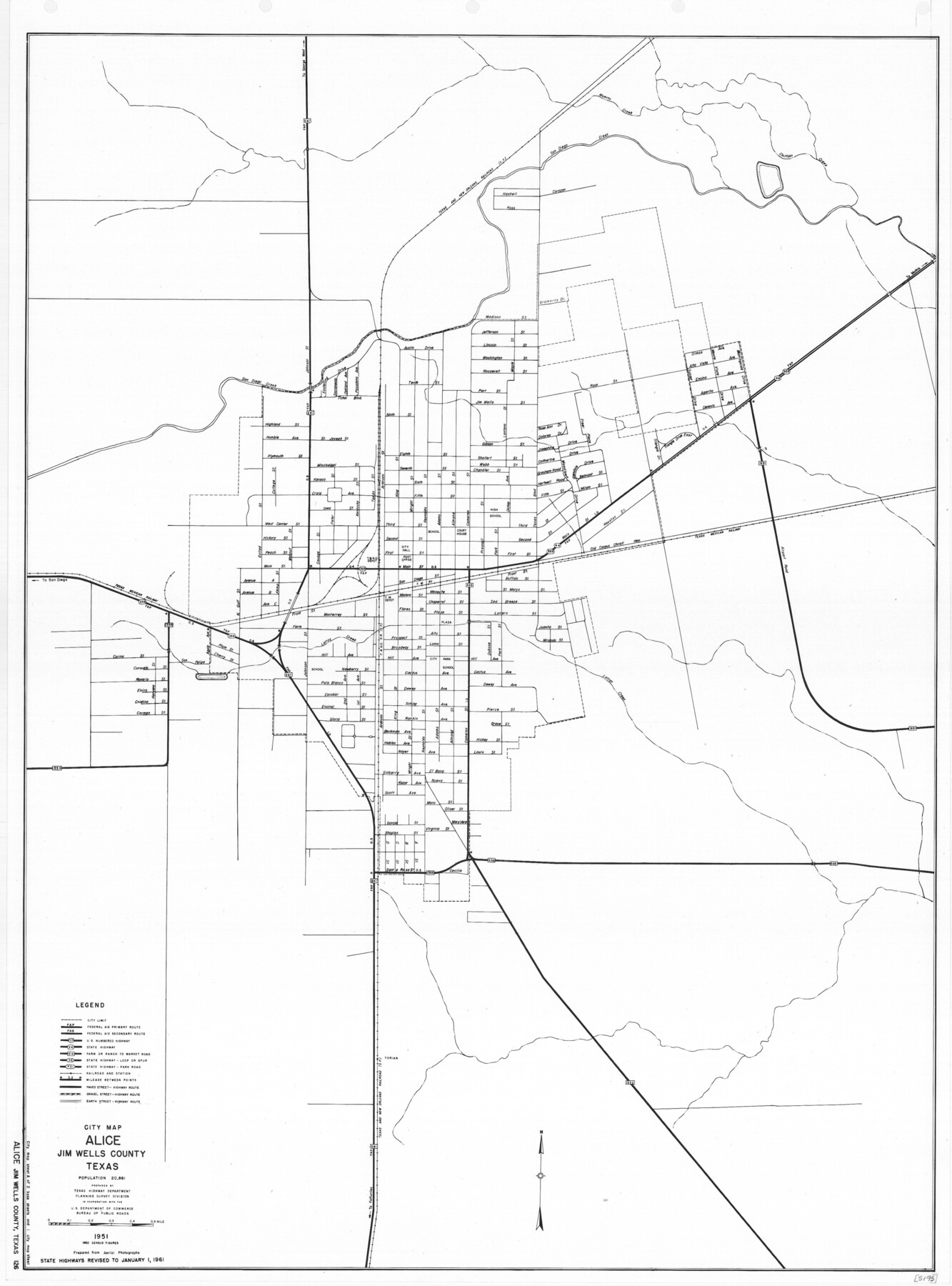
General Highway Map. Detail of Cities and Towns in Jim Wells County, Texas. City Map of Alice, Jim Wells County, Texas
-
Map/Doc
79544
-
Collection
Texas State Library and Archives
-
Object Dates
1961 (Creation Date)
-
People and Organizations
Texas State Highway Department (Publisher)
-
Counties
Jim Wells
-
Subjects
City County
-
Height x Width
24.6 x 18.3 inches
62.5 x 46.5 cm
-
Comments
Prints available courtesy of the Texas State Library and Archives.
More info can be found here: TSLAC Map 05195
Part of: Texas State Library and Archives
Karte von Texas entworfen nach den Vermessungen, welche in den Acten der General-Land-Office der Republic liegen bis zum Jahr 1839 von Richard S. Hunt & Jesse F. Randel

Print $20.00
Karte von Texas entworfen nach den Vermessungen, welche in den Acten der General-Land-Office der Republic liegen bis zum Jahr 1839 von Richard S. Hunt & Jesse F. Randel
1841
Size 19.6 x 14.6 inches
Map/Doc 79311
General Highway Map, Angelina County, Texas

Print $20.00
General Highway Map, Angelina County, Texas
1940
Size 18.5 x 24.9 inches
Map/Doc 79003
General Highway Map, Dallas County, Rockwall County, Texas

Print $20.00
General Highway Map, Dallas County, Rockwall County, Texas
1936
Size 18.7 x 25.2 inches
Map/Doc 79066
General Highway Map. Detail of Cities and Towns in Tarrant County, Texas. City Map, Fort Worth and vicinity, Tarrant County, Texas

Print $20.00
General Highway Map. Detail of Cities and Towns in Tarrant County, Texas. City Map, Fort Worth and vicinity, Tarrant County, Texas
1961
Size 18.1 x 24.9 inches
Map/Doc 79668
Map of the Country Upon the Brazos and Big Wichita Rivers Embracing the Lands appropriated by the State of Texas for the Use of the Indians

Print $20.00
Map of the Country Upon the Brazos and Big Wichita Rivers Embracing the Lands appropriated by the State of Texas for the Use of the Indians
1854
Size 28.8 x 32.3 inches
Map/Doc 76284
General Highway Map, Dickens County, Texas

Print $20.00
General Highway Map, Dickens County, Texas
1961
Size 18.2 x 24.9 inches
Map/Doc 79443
General Highway Map, Wilbarger County, Texas

Print $20.00
General Highway Map, Wilbarger County, Texas
1940
Size 24.7 x 18.1 inches
Map/Doc 79278
General Highway Map. Detail of Cities and Towns in Dallas County, Texas [Dallas and vicinity]
![79431, General Highway Map. Detail of Cities and Towns in Dallas County, Texas [Dallas and vicinity], Texas State Library and Archives](https://historictexasmaps.com/wmedia_w700/maps/79431.tif.jpg)
Print $20.00
General Highway Map. Detail of Cities and Towns in Dallas County, Texas [Dallas and vicinity]
1961
Size 18.1 x 24.4 inches
Map/Doc 79431
General Highway Map, Comanche County, Texas

Print $20.00
General Highway Map, Comanche County, Texas
1961
Size 24.7 x 18.2 inches
Map/Doc 79419
Description of Best Route from Austin to San Antonio, Texas

Print $20.00
Description of Best Route from Austin to San Antonio, Texas
1865
Size 12.9 x 13.1 inches
Map/Doc 79296
General Highway Map, Zapata County, Texas

Print $20.00
General Highway Map, Zapata County, Texas
1961
Size 18.2 x 24.8 inches
Map/Doc 79721
General Highway Map, San Augustine County, Texas

Print $20.00
General Highway Map, San Augustine County, Texas
1961
Size 24.6 x 18.1 inches
Map/Doc 79645
You may also like
Harris County Working Sketch 86

Print $20.00
- Digital $50.00
Harris County Working Sketch 86
1972
Size 42.7 x 31.9 inches
Map/Doc 65978
Haskell County Working Sketch 2

Print $3.00
- Digital $50.00
Haskell County Working Sketch 2
1914
Size 14.9 x 10.1 inches
Map/Doc 66060
Edwards County Sketch File 16a

Print $24.00
- Digital $50.00
Edwards County Sketch File 16a
1903
Size 14.3 x 8.8 inches
Map/Doc 21720
Aransas County Rolled Sketch 18

Print $29.00
- Digital $50.00
Aransas County Rolled Sketch 18
1965
Size 11.0 x 15.1 inches
Map/Doc 42328
The Judicial District/County of DeWitt. Abolished, Spring 1842

Print $20.00
The Judicial District/County of DeWitt. Abolished, Spring 1842
2020
Size 22.4 x 21.7 inches
Map/Doc 96326
Bosque County

Print $40.00
- Digital $50.00
Bosque County
1945
Size 48.8 x 38.7 inches
Map/Doc 95432
[Right of Way & Track Map, The Texas & Pacific Ry. Co. Main Line]
![64661, [Right of Way & Track Map, The Texas & Pacific Ry. Co. Main Line], General Map Collection](https://historictexasmaps.com/wmedia_w700/maps/64661.tif.jpg)
Print $20.00
- Digital $50.00
[Right of Way & Track Map, The Texas & Pacific Ry. Co. Main Line]
Size 11.0 x 18.6 inches
Map/Doc 64661
Nueces County Sketch File 35

Print $2.00
- Digital $50.00
Nueces County Sketch File 35
1913
Size 13.1 x 4.8 inches
Map/Doc 32613
Pecos County Working Sketch 72

Print $40.00
- Digital $50.00
Pecos County Working Sketch 72
1957
Size 106.0 x 43.6 inches
Map/Doc 71544
General Highway Map, Mason County, Texas

Print $20.00
General Highway Map, Mason County, Texas
1940
Size 18.2 x 24.5 inches
Map/Doc 79186
Jim Hogg County Rolled Sketch 8

Print $20.00
- Digital $50.00
Jim Hogg County Rolled Sketch 8
1956
Size 32.1 x 38.2 inches
Map/Doc 9323
Flight Mission No. DAG-21K, Frame 39, Matagorda County

Print $20.00
- Digital $50.00
Flight Mission No. DAG-21K, Frame 39, Matagorda County
1952
Size 18.6 x 22.3 inches
Map/Doc 86406