Old Miscellaneous File 20
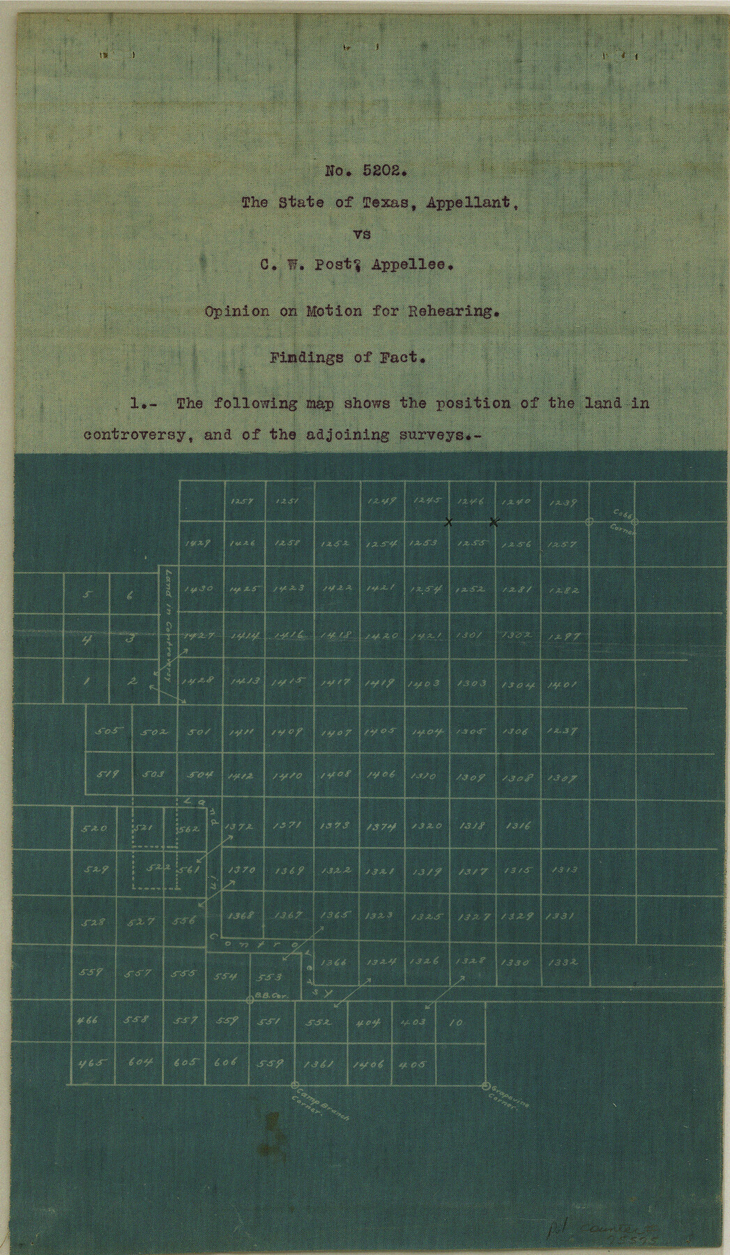
Court Opinion in Case No. 5202, The State of Texas vs. C. W. Post regarding position of surveys
-
Map/Doc
75575
-
Collection
General Map Collection
-
Object Dates
1913/10/22 (Creation Date)
1984/12/13 (File Date)
-
Subjects
Legal
-
Height x Width
13.6 x 7.9 inches
34.5 x 20.1 cm
Part of: General Map Collection
Menard County Working Sketch 12

Print $20.00
- Digital $50.00
Menard County Working Sketch 12
1939
Size 24.7 x 30.0 inches
Map/Doc 70959
Starr County Sketch File 35

Print $24.00
- Digital $50.00
Starr County Sketch File 35
1939
Size 14.3 x 8.8 inches
Map/Doc 36974
Floyd County Working Sketch 5

Print $20.00
- Digital $50.00
Floyd County Working Sketch 5
1955
Size 33.3 x 23.6 inches
Map/Doc 69184
Flight Mission No. BRE-1P, Frame 75, Nueces County

Print $20.00
- Digital $50.00
Flight Mission No. BRE-1P, Frame 75, Nueces County
1956
Size 18.4 x 22.2 inches
Map/Doc 86657
United States - Gulf Coast - Padre I. and Laguna Madre Lat. 27° 12' to Lat. 26° 33' Texas

Print $20.00
- Digital $50.00
United States - Gulf Coast - Padre I. and Laguna Madre Lat. 27° 12' to Lat. 26° 33' Texas
1913
Size 27.1 x 18.3 inches
Map/Doc 72816
Goliad County Sketch File 13

Print $8.00
- Digital $50.00
Goliad County Sketch File 13
1856
Size 12.4 x 8.0 inches
Map/Doc 24239
Zapata County Rolled Sketch 9

Print $20.00
- Digital $50.00
Zapata County Rolled Sketch 9
1912
Size 15.0 x 15.5 inches
Map/Doc 8310
Flight Mission No. BRA-16M, Frame 62, Jefferson County

Print $20.00
- Digital $50.00
Flight Mission No. BRA-16M, Frame 62, Jefferson County
1953
Size 18.7 x 22.4 inches
Map/Doc 85679
Real County Rolled Sketch 12

Print $40.00
- Digital $50.00
Real County Rolled Sketch 12
Size 42.7 x 54.6 inches
Map/Doc 9836
Brazoria County Sketch File 28

Print $6.00
- Digital $50.00
Brazoria County Sketch File 28
1889
Size 8.8 x 14.2 inches
Map/Doc 15030
Flight Mission No. DAG-17K, Frame 62, Matagorda County

Print $20.00
- Digital $50.00
Flight Mission No. DAG-17K, Frame 62, Matagorda County
1952
Size 16.4 x 16.4 inches
Map/Doc 86324
Uvalde County Working Sketch 47

Print $20.00
- Digital $50.00
Uvalde County Working Sketch 47
1979
Size 29.7 x 24.8 inches
Map/Doc 72117
You may also like
Erath County Working Sketch 24

Print $20.00
- Digital $50.00
Erath County Working Sketch 24
1967
Size 41.5 x 39.3 inches
Map/Doc 69105
[E. T. Ry. Blk. 1]
![89797, [E. T. Ry. Blk. 1], Twichell Survey Records](https://historictexasmaps.com/wmedia_w700/maps/89797-1.tif.jpg)
Print $40.00
- Digital $50.00
[E. T. Ry. Blk. 1]
Size 41.8 x 49.9 inches
Map/Doc 89797
Lubbock County

Print $20.00
- Digital $50.00
Lubbock County
1879
Size 21.3 x 19.1 inches
Map/Doc 4583
Anderson County Working Sketch 33

Print $20.00
- Digital $50.00
Anderson County Working Sketch 33
1966
Size 30.8 x 29.9 inches
Map/Doc 67033
Aransas County Sketch File 8

Print $4.00
- Digital $50.00
Aransas County Sketch File 8
Size 11.7 x 7.9 inches
Map/Doc 13114
Right of Way and Track Map, the Missouri, Kansas and Texas Ry. of Texas - Henrietta Division

Print $20.00
- Digital $50.00
Right of Way and Track Map, the Missouri, Kansas and Texas Ry. of Texas - Henrietta Division
1918
Size 11.7 x 26.8 inches
Map/Doc 64756
Clay County Sketch File 21

Print $2.00
- Digital $50.00
Clay County Sketch File 21
1882
Size 11.3 x 8.7 inches
Map/Doc 18435
Gregg County Rolled Sketch 12

Print $40.00
- Digital $50.00
Gregg County Rolled Sketch 12
1939
Size 49.5 x 55.5 inches
Map/Doc 9065
Erforschung von Nordwest-Texas

Print $20.00
- Digital $50.00
Erforschung von Nordwest-Texas
1873
Size 11.4 x 9.4 inches
Map/Doc 95144
Terrell County Rolled Sketch 46

Print $20.00
- Digital $50.00
Terrell County Rolled Sketch 46
1958
Size 16.1 x 14.6 inches
Map/Doc 7948
Flight Mission No. DCL-7C, Frame 115, Kenedy County

Print $20.00
- Digital $50.00
Flight Mission No. DCL-7C, Frame 115, Kenedy County
1943
Size 18.4 x 22.2 inches
Map/Doc 86080
Matagorda Light to Aransas Pass

Print $20.00
- Digital $50.00
Matagorda Light to Aransas Pass
1974
Size 36.5 x 45.3 inches
Map/Doc 73401