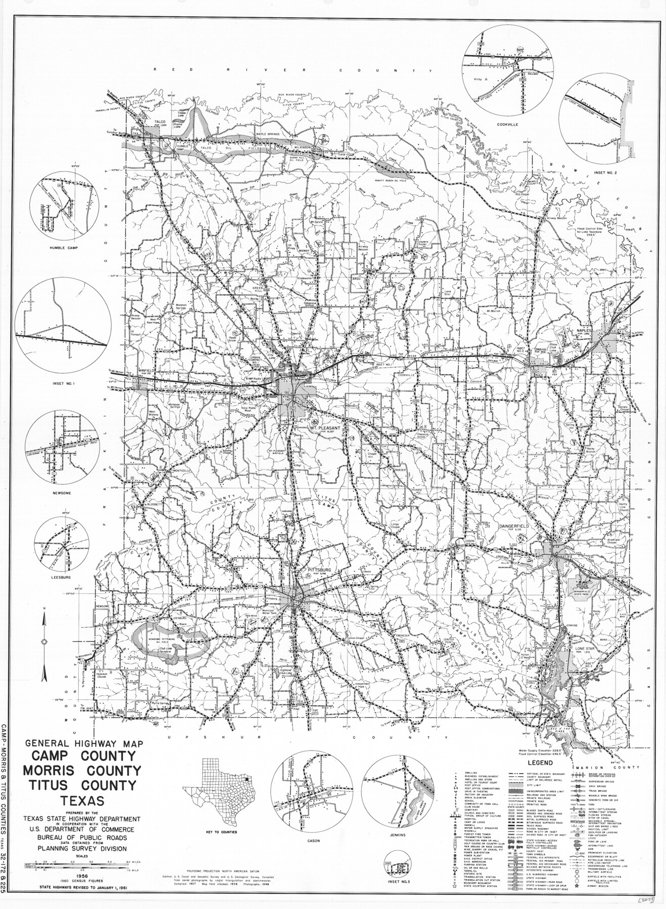
General Highway Map, Camp County, Morris County, Titus County, Texas
-
Map/Doc
79400
-
Collection
Texas State Library and Archives
-
Object Dates
1961 (Creation Date)
-
People and Organizations
Texas State Highway Department (Publisher)
-
Counties
Camp Morris Titus
-
Subjects
City County
-
Height x Width
24.7 x 18.1 inches
62.7 x 46.0 cm
-
Comments
Prints available courtesy of the Texas State Library and Archives.
More info can be found here: TSLAC Map 05077
Part of: Texas State Library and Archives
General Highway Map, Dallas County, Rockwall County, Texas

Print $20.00
General Highway Map, Dallas County, Rockwall County, Texas
1961
Size 18.4 x 24.5 inches
Map/Doc 79430
General Highway Map, Terry County, Texas

Print $20.00
General Highway Map, Terry County, Texas
1961
Size 18.1 x 24.9 inches
Map/Doc 79675
General Highway Map, Shelby County, Texas

Print $20.00
General Highway Map, Shelby County, Texas
1940
Size 18.3 x 24.8 inches
Map/Doc 79242
General Highway Map. Detail of Cities and Towns in Bexar County, Texas [San Antonio and vicinity]
![79019, General Highway Map. Detail of Cities and Towns in Bexar County, Texas [San Antonio and vicinity], Texas State Library and Archives](https://historictexasmaps.com/wmedia_w700/maps/79019.tif.jpg)
Print $20.00
General Highway Map. Detail of Cities and Towns in Bexar County, Texas [San Antonio and vicinity]
1940
Size 18.6 x 25.0 inches
Map/Doc 79019
General Highway Map, Ward County, Texas

Print $20.00
General Highway Map, Ward County, Texas
1940
Size 18.5 x 25.1 inches
Map/Doc 79271
General Highway Map, Parker County, Texas

Print $20.00
General Highway Map, Parker County, Texas
1961
Size 18.3 x 24.5 inches
Map/Doc 79625
General Highway Map, Bexar County, Texas

Print $20.00
General Highway Map, Bexar County, Texas
1940
Size 18.4 x 25.1 inches
Map/Doc 76287
General Highway Map, Archer County, Texas

Print $20.00
General Highway Map, Archer County, Texas
1940
Size 18.2 x 24.8 inches
Map/Doc 79005
General Highway Map, San Augustine County, Texas

Print $20.00
General Highway Map, San Augustine County, Texas
1961
Size 24.6 x 18.1 inches
Map/Doc 79645
General Highway Map, Stephens County, Texas

Print $20.00
General Highway Map, Stephens County, Texas
1940
Size 24.9 x 18.3 inches
Map/Doc 79247
General Highway Map, Tarrant County, Texas

Print $20.00
General Highway Map, Tarrant County, Texas
1961
Size 18.3 x 25.1 inches
Map/Doc 79664
Carte Geographique, Statistique et Historique du Mexique

Print $20.00
Carte Geographique, Statistique et Historique du Mexique
1824
Size 22.3 x 28.1 inches
Map/Doc 79315
You may also like
Flight Mission No. BQR-20K, Frame 11, Brazoria County

Print $20.00
- Digital $50.00
Flight Mission No. BQR-20K, Frame 11, Brazoria County
1952
Size 18.7 x 22.3 inches
Map/Doc 84113

Panola County Sketch File 16

Print $4.00
- Digital $50.00
Panola County Sketch File 16
1882
Size 6.4 x 8.8 inches
Map/Doc 33476
Sketch showing surveys on Harbor Island in Nueces County

Print $20.00
- Digital $50.00
Sketch showing surveys on Harbor Island in Nueces County
1978
Size 46.4 x 36.0 inches
Map/Doc 2020
Map of the River Sabine from its mouth on the Gulf of Mexico in the sea to Logan's Ferry in latitude 31° 58' 24" north

Print $20.00
- Digital $50.00
Map of the River Sabine from its mouth on the Gulf of Mexico in the sea to Logan's Ferry in latitude 31° 58' 24" north
1842
Size 18.3 x 9.3 inches
Map/Doc 65383
Flight Mission No. BRE-1P, Frame 99, Nueces County

Print $20.00
- Digital $50.00
Flight Mission No. BRE-1P, Frame 99, Nueces County
1956
Size 18.4 x 22.2 inches
Map/Doc 86670
Blanco County Sketch File 12

Print $20.00
- Digital $50.00
Blanco County Sketch File 12
Size 15.0 x 19.8 inches
Map/Doc 10928
Midland County Sketch File 18

Print $4.00
- Digital $50.00
Midland County Sketch File 18
Size 14.7 x 8.1 inches
Map/Doc 31585
Matagorda County NRC Article 33.136 Sketch 21

Print $42.00
Matagorda County NRC Article 33.136 Sketch 21
2025
Map/Doc 97429
Flight Mission No. DAG-17K, Frame 129, Matagorda County

Print $20.00
- Digital $50.00
Flight Mission No. DAG-17K, Frame 129, Matagorda County
1952
Size 18.6 x 22.3 inches
Map/Doc 86349
Aransas Pass to Baffin Bay

Print $20.00
- Digital $50.00
Aransas Pass to Baffin Bay
1922
Size 18.6 x 27.8 inches
Map/Doc 73409
Jeff Davis County Working Sketch 38

Print $20.00
- Digital $50.00
Jeff Davis County Working Sketch 38
1980
Size 25.3 x 34.4 inches
Map/Doc 66533