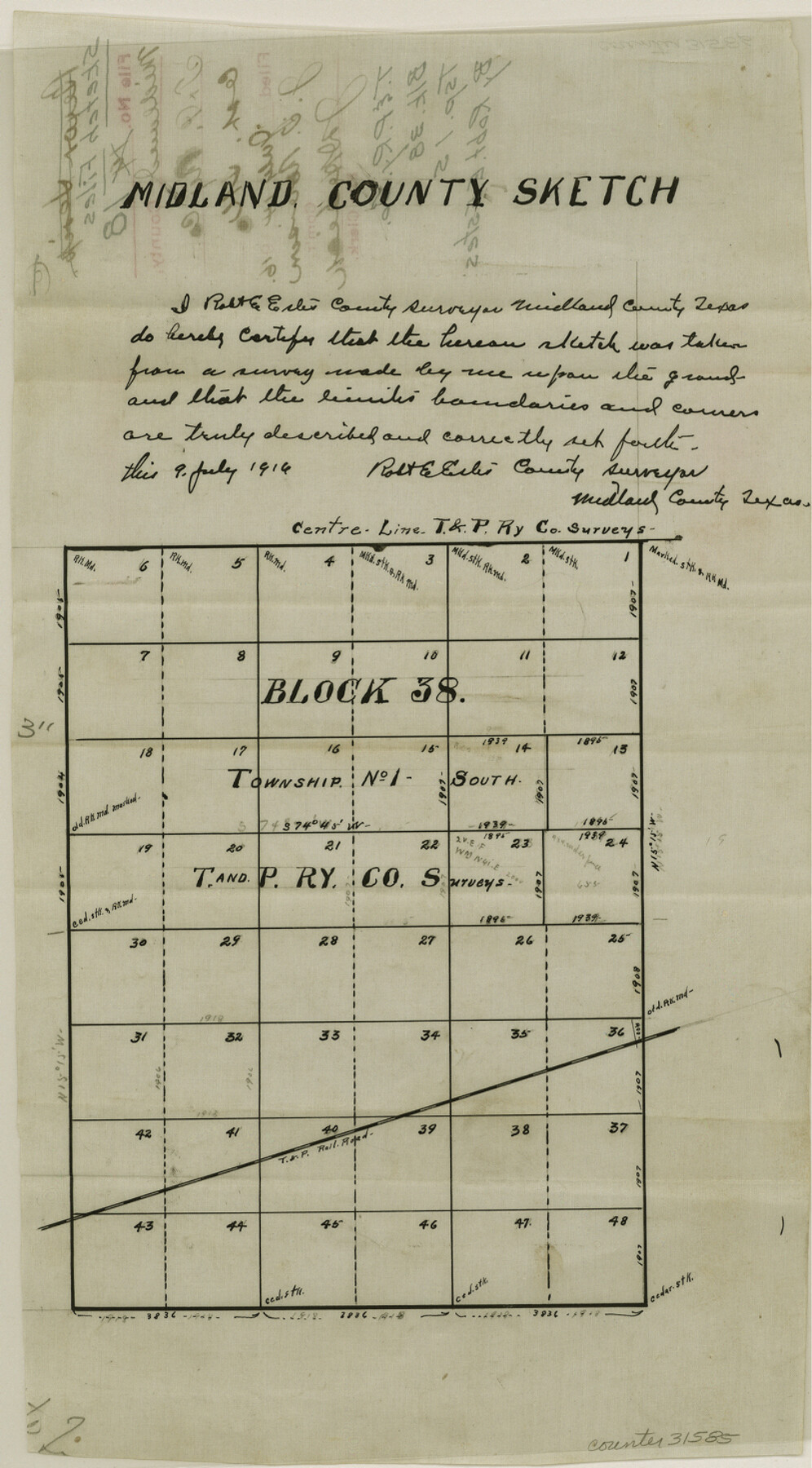
Midland County Sketch File 18
[Sketch of T. & P. RR. Co. Block 38, Township 1S]
-
Map/Doc
31585
-
Collection
General Map Collection
-
Object Dates
7/14/1916 (File Date)
-
People and Organizations
Robert E. Estes (Surveyor/Engineer)
-
Counties
Midland Martin
-
Subjects
Surveying Sketch File
-
Height x Width
14.7 x 8.1 inches
37.3 x 20.6 cm
-
Medium
paper, manuscript
-
Features
T&P
Part of: General Map Collection
Flight Mission No. BQR-13K, Frame 161, Brazoria County

Print $20.00
- Digital $50.00
Flight Mission No. BQR-13K, Frame 161, Brazoria County
1952
Size 18.7 x 22.3 inches
Map/Doc 84086
Old Miscellaneous File 27a

Print $142.00
- Digital $50.00
Old Miscellaneous File 27a
Size 14.2 x 8.8 inches
Map/Doc 75651
Map of Donley County

Print $20.00
- Digital $50.00
Map of Donley County
1894
Size 44.6 x 35.8 inches
Map/Doc 16823
Controlled Mosaic by Jack Amman Photogrammetric Engineers, Inc - Sheet 7

Print $20.00
- Digital $50.00
Controlled Mosaic by Jack Amman Photogrammetric Engineers, Inc - Sheet 7
1954
Size 20.0 x 24.0 inches
Map/Doc 83451
Hamilton County Sketch File 20

Print $26.00
- Digital $50.00
Hamilton County Sketch File 20
1935
Size 14.4 x 9.1 inches
Map/Doc 24942
Comal County Working Sketch 8

Print $20.00
- Digital $50.00
Comal County Working Sketch 8
1971
Size 41.6 x 25.6 inches
Map/Doc 68174
Reeves County Rolled Sketch 19

Print $20.00
- Digital $50.00
Reeves County Rolled Sketch 19
1969
Size 23.8 x 21.5 inches
Map/Doc 7488
Williamson County Sketch File 29

Print $18.00
- Digital $50.00
Williamson County Sketch File 29
Size 10.2 x 8.2 inches
Map/Doc 40377
Flight Mission No. CRC-2R, Frame 184, Chambers County

Print $20.00
- Digital $50.00
Flight Mission No. CRC-2R, Frame 184, Chambers County
1956
Size 18.6 x 22.2 inches
Map/Doc 84762
McLennan County Working Sketch 6

Print $20.00
- Digital $50.00
McLennan County Working Sketch 6
1957
Size 26.7 x 24.8 inches
Map/Doc 70699
Uvalde County Sketch File 24

Print $42.00
- Digital $50.00
Uvalde County Sketch File 24
1926
Size 19.4 x 29.9 inches
Map/Doc 12536
Hemphill County Working Sketch 17

Print $20.00
- Digital $50.00
Hemphill County Working Sketch 17
1972
Size 33.6 x 45.0 inches
Map/Doc 66112
You may also like
Map and Profile No. 1 from the Red River to the Rio Grande; from Explorations and surveys made under the direction of the Hon. Jeffeson Davis, Secretary of War

Print $40.00
- Digital $50.00
Map and Profile No. 1 from the Red River to the Rio Grande; from Explorations and surveys made under the direction of the Hon. Jeffeson Davis, Secretary of War
1856
Size 30.5 x 57.0 inches
Map/Doc 4330
Real County Working Sketch 24

Print $20.00
- Digital $50.00
Real County Working Sketch 24
1946
Size 17.4 x 22.5 inches
Map/Doc 71916
Colorado County Working Sketch 32

Print $20.00
- Digital $50.00
Colorado County Working Sketch 32
1985
Size 42.7 x 36.8 inches
Map/Doc 68132
Mason County Working Sketch 7

Print $20.00
- Digital $50.00
Mason County Working Sketch 7
1945
Size 35.8 x 43.9 inches
Map/Doc 70843
Brewster County Working Sketch 51

Print $40.00
- Digital $50.00
Brewster County Working Sketch 51
1950
Size 62.9 x 26.4 inches
Map/Doc 67585
Wichita County Working Sketch 19

Print $20.00
- Digital $50.00
Wichita County Working Sketch 19
1949
Size 18.1 x 30.9 inches
Map/Doc 72529
City of Austin and Vicinity

Print $20.00
- Digital $50.00
City of Austin and Vicinity
1839
Size 20.4 x 19.6 inches
Map/Doc 3149
Flight Mission No. CRC-3R, Frame 17, Chambers County

Print $20.00
- Digital $50.00
Flight Mission No. CRC-3R, Frame 17, Chambers County
1956
Size 18.6 x 22.2 inches
Map/Doc 84791
Leon County Sketch File 35-2

Print $20.00
- Digital $50.00
Leon County Sketch File 35-2
1966
Size 24.3 x 20.4 inches
Map/Doc 11994
Copy of Surveyor's Field Book, Morris Browning - In Blocks 7, 5 & 4, I&GNRRCo., Hutchinson and Carson Counties, Texas

Print $2.00
- Digital $50.00
Copy of Surveyor's Field Book, Morris Browning - In Blocks 7, 5 & 4, I&GNRRCo., Hutchinson and Carson Counties, Texas
1888
Size 7.0 x 8.8 inches
Map/Doc 62279
Brewster County Rolled Sketch 153

Print $20.00
- Digital $50.00
Brewster County Rolled Sketch 153
Size 32.4 x 19.2 inches
Map/Doc 5320
[Block 36, Townships 1 and 2 North]
![91364, [Block 36, Townships 1 and 2 North], Twichell Survey Records](https://historictexasmaps.com/wmedia_w700/maps/91364-1.tif.jpg)
Print $20.00
- Digital $50.00
[Block 36, Townships 1 and 2 North]
Size 17.3 x 35.4 inches
Map/Doc 91364