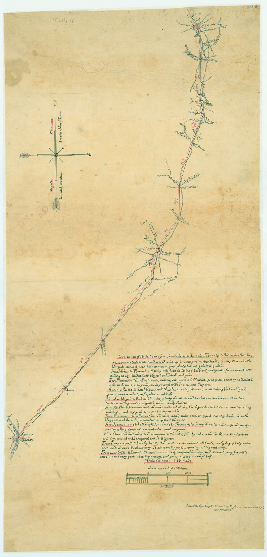
Description of Best Route from San Antonio to Laredo, Texas
-
Map/Doc
79302
-
Collection
Texas State Library and Archives
-
Object Dates
[1865 ca.] (Creation Date)
-
People and Organizations
A.R. Roessler (Author)
-
Counties
Bexar Medina Frio La Salle Webb
-
Subjects
Military
-
Height x Width
28.6 x 13.7 inches
72.6 x 34.8 cm
-
Comments
Prints available courtesy of the Texas State Library and Archives.
More info can be found here: TSLAC Map 01004q
Part of: Texas State Library and Archives
General Highway Map. Detail of Cities and Towns in Tarrant County, Texas. City Map, Fort Worth and vicinity, Tarrant County, Texas

Print $20.00
General Highway Map. Detail of Cities and Towns in Tarrant County, Texas. City Map, Fort Worth and vicinity, Tarrant County, Texas
1961
Size 18.2 x 25.0 inches
Map/Doc 79670
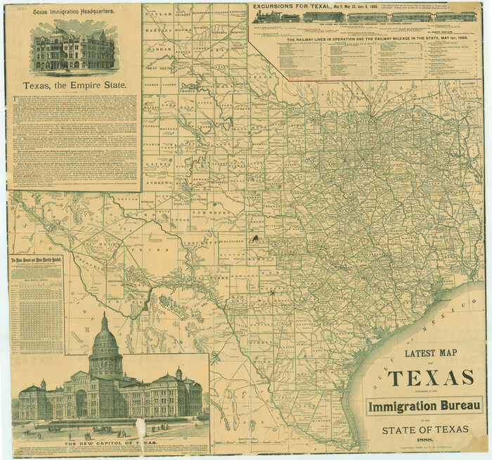
Latest Map of the State of Texas
Print $20.00
Latest Map of the State of Texas
1888
Size 30.7 x 32.9 inches
Map/Doc 79747
Karte des Staates, Texas

Print $20.00
Karte des Staates, Texas
1851
Size 27.2 x 30.1 inches
Map/Doc 76262
Carte Geographique, Statistique et Historique du Mexique

Print $20.00
Carte Geographique, Statistique et Historique du Mexique
1824
Size 22.3 x 28.1 inches
Map/Doc 79315
Greenville, Hunt County, Texas

Print $20.00
Greenville, Hunt County, Texas
1891
Size 21.9 x 36.5 inches
Map/Doc 79749
Oil and Gas Fields in the State of Texas

Print $40.00
Oil and Gas Fields in the State of Texas
1927
Size 58.2 x 38.1 inches
Map/Doc 76303
General Highway Map. Detail of Cities and Towns in Harris County, Texas. City Map [of] Houston, Pasadena, West University Place, Bellaire, Galena Park, Jacinto City, South Houston, South Side Place, Deer Park, and vicinity, Harris County, Texas
![79506, General Highway Map. Detail of Cities and Towns in Harris County, Texas. City Map [of] Houston, Pasadena, West University Place, Bellaire, Galena Park, Jacinto City, South Houston, South Side Place, Deer Park, and vicinity, Harris County, Texas, Texas State Library and Archives](https://historictexasmaps.com/wmedia_w700/maps/79506.tif.jpg)
Print $20.00
General Highway Map. Detail of Cities and Towns in Harris County, Texas. City Map [of] Houston, Pasadena, West University Place, Bellaire, Galena Park, Jacinto City, South Houston, South Side Place, Deer Park, and vicinity, Harris County, Texas
1961
Size 18.0 x 24.9 inches
Map/Doc 79506
General Highway Map, Hardin County, Texas

Print $20.00
General Highway Map, Hardin County, Texas
1940
Size 18.4 x 24.8 inches
Map/Doc 79114
General Highway Map, Jim Wells County, Texas

Print $20.00
General Highway Map, Jim Wells County, Texas
1961
Size 18.1 x 24.7 inches
Map/Doc 79542
General Highway Map, Hamilton County, Texas

Print $20.00
General Highway Map, Hamilton County, Texas
1961
Size 18.1 x 24.9 inches
Map/Doc 79496
General Highway Map, Limestone County, Texas

Print $20.00
General Highway Map, Limestone County, Texas
1940
Size 18.3 x 24.9 inches
Map/Doc 79174
City of San Antonio, Texas

Print $20.00
City of San Antonio, Texas
1889
Size 34.2 x 34.1 inches
Map/Doc 76187
You may also like
Laneer vs. Bivins, Potter County, Texas

Print $20.00
- Digital $50.00
Laneer vs. Bivins, Potter County, Texas
Size 21.2 x 18.8 inches
Map/Doc 93100
Smith County Rolled Sketch 6E2

Print $20.00
- Digital $50.00
Smith County Rolled Sketch 6E2
1960
Size 27.6 x 22.7 inches
Map/Doc 10613
Harris County Historic Topographic 15

Print $20.00
- Digital $50.00
Harris County Historic Topographic 15
1916
Size 29.2 x 22.9 inches
Map/Doc 65825
Val Verde County

Print $20.00
- Digital $50.00
Val Verde County
1944
Size 42.0 x 37.0 inches
Map/Doc 63103
Hunt County Working Sketch 3

Print $20.00
- Digital $50.00
Hunt County Working Sketch 3
1923
Size 20.6 x 28.2 inches
Map/Doc 66350
Geographical Observations on the Inner Margins of the Border and Coastal Reserves of Texas, 1824-1836

Geographical Observations on the Inner Margins of the Border and Coastal Reserves of Texas, 1824-1836
2022
Map/Doc 97131
Flight Mission No. DAG-18K, Frame 184, Matagorda County

Print $20.00
- Digital $50.00
Flight Mission No. DAG-18K, Frame 184, Matagorda County
1952
Size 18.6 x 22.4 inches
Map/Doc 86376
Dallas County Boundary File 5a

Print $4.00
- Digital $50.00
Dallas County Boundary File 5a
Size 4.9 x 8.6 inches
Map/Doc 52182
Dallam County Working Sketch 3

Print $20.00
- Digital $50.00
Dallam County Working Sketch 3
1960
Size 13.8 x 30.5 inches
Map/Doc 68588
Bandera County Boundary File 6

Print $42.00
- Digital $50.00
Bandera County Boundary File 6
1972
Size 14.2 x 8.9 inches
Map/Doc 50303
Map Showing Corrections of Capitol Leagues in Conflict in Oldham Co.

Print $40.00
- Digital $50.00
Map Showing Corrections of Capitol Leagues in Conflict in Oldham Co.
1886
Size 52.5 x 31.3 inches
Map/Doc 89800
[Sketch for Mineral Application 13271- Trinity River]
![65628, [Sketch for Mineral Application 13271- Trinity River], General Map Collection](https://historictexasmaps.com/wmedia_w700/maps/65628.tif.jpg)
Print $40.00
- Digital $50.00
[Sketch for Mineral Application 13271- Trinity River]
1925
Size 63.1 x 22.4 inches
Map/Doc 65628