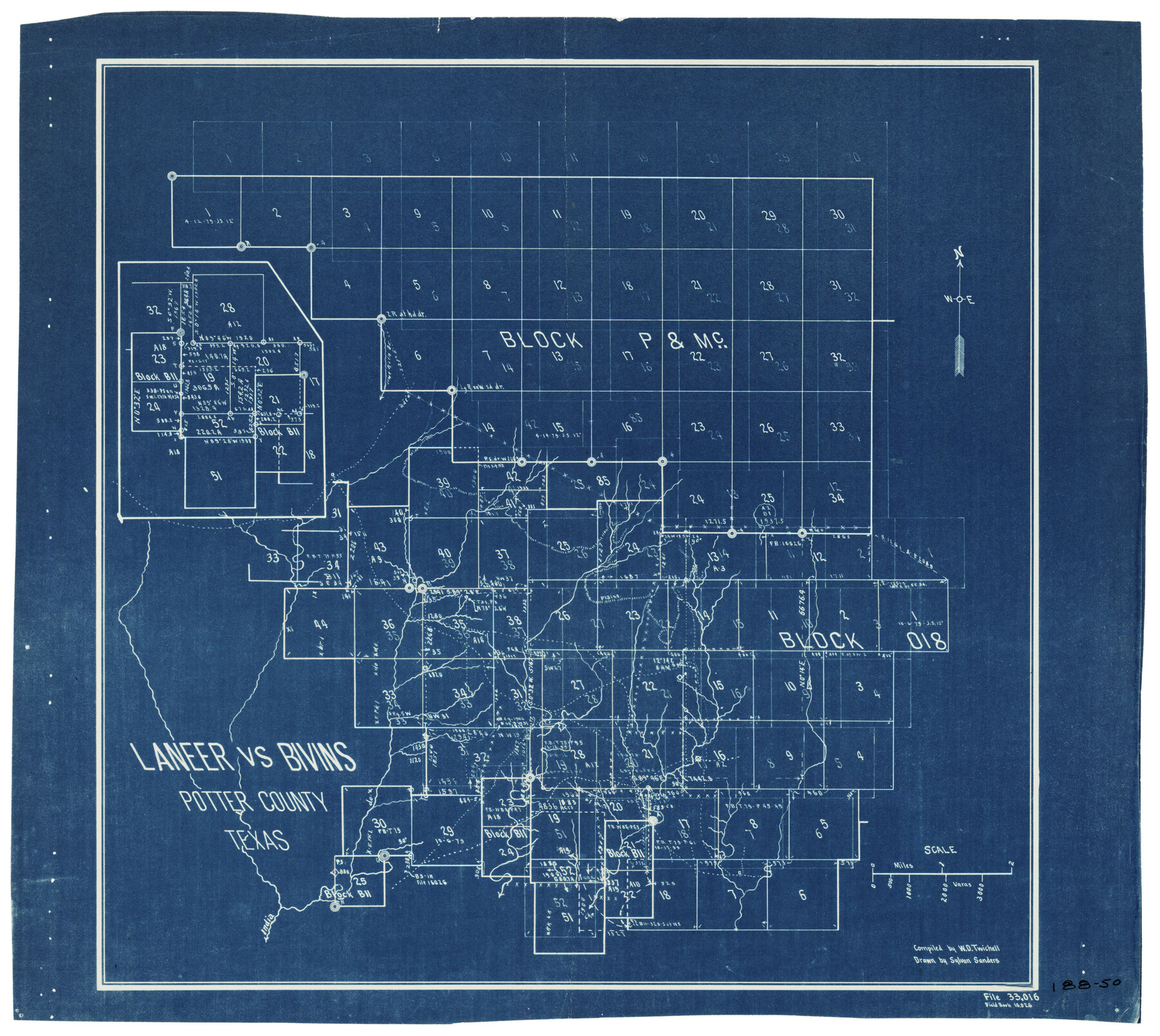
Laneer vs. Bivins, Potter County, Texas
188-50
-
Map/Doc
93100
-
Collection
Twichell Survey Records
-
People and Organizations
Sylvan Sanders (Draftsman)
W.D. Twichell (Compiler)
-
Counties
Potter
-
Height x Width
21.2 x 18.8 inches
53.9 x 47.8 cm
Part of: Twichell Survey Records
Working Sketch Hutchinson County

Print $20.00
- Digital $50.00
Working Sketch Hutchinson County
1920
Size 43.4 x 37.2 inches
Map/Doc 89709
[Sketch showing details along East line of Lipscomb County]
![89968, [Sketch showing details along East line of Lipscomb County], Twichell Survey Records](https://historictexasmaps.com/wmedia_w700/maps/89968-1.tif.jpg)
Print $40.00
- Digital $50.00
[Sketch showing details along East line of Lipscomb County]
Size 9.9 x 66.3 inches
Map/Doc 89968
Section 50, H. & G. N. Block 1

Print $20.00
- Digital $50.00
Section 50, H. & G. N. Block 1
Size 18.8 x 24.9 inches
Map/Doc 90816
[Sketch showing Blocks B-11, O-18, P and Mc in case of Laneer vs. Bivens]
![91727, [Sketch showing Blocks B-11, O-18, P and Mc in case of Laneer vs. Bivens], Twichell Survey Records](https://historictexasmaps.com/wmedia_w700/maps/91727-1.tif.jpg)
Print $20.00
- Digital $50.00
[Sketch showing Blocks B-11, O-18, P and Mc in case of Laneer vs. Bivens]
Size 20.9 x 18.9 inches
Map/Doc 91727
[Blocks H and C41]
![92623, [Blocks H and C41], Twichell Survey Records](https://historictexasmaps.com/wmedia_w700/maps/92623-1.tif.jpg)
Print $20.00
- Digital $50.00
[Blocks H and C41]
1951
Size 24.6 x 18.8 inches
Map/Doc 92623
![90713, [Capitol Lands], Twichell Survey Records](https://historictexasmaps.com/wmedia_w700/maps/90713-1.tif.jpg)
[Wilson Strickland Survey]
![91378, [Wilson Strickland Survey], Twichell Survey Records](https://historictexasmaps.com/wmedia_w700/maps/91378-1.tif.jpg)
Print $20.00
- Digital $50.00
[Wilson Strickland Survey]
Size 39.7 x 29.2 inches
Map/Doc 91378
[Motley and Foard County School Land Leagues]
![90179, [Motley and Foard County School Land Leagues], Twichell Survey Records](https://historictexasmaps.com/wmedia_w700/maps/90179-1.tif.jpg)
Print $20.00
- Digital $50.00
[Motley and Foard County School Land Leagues]
Size 22.8 x 29.6 inches
Map/Doc 90179
[Letter from T. F. Pinckney to W. D. Twichell accompanying sketch showing Blocks 14, 341, and G5]
![93111, [Letter from T. F. Pinckney to W. D. Twichell accompanying sketch showing Blocks 14, 341, and G5], Twichell Survey Records](https://historictexasmaps.com/wmedia_w700/maps/93111-1.tif.jpg)
Print $2.00
- Digital $50.00
[Letter from T. F. Pinckney to W. D. Twichell accompanying sketch showing Blocks 14, 341, and G5]
Size 15.1 x 7.9 inches
Map/Doc 93111
[Sketch showing the area around the state line in Roberts and Clay Counties, along the north bank of the Canadian River]
![91762, [Sketch showing the area around the state line in Roberts and Clay Counties, along the north bank of the Canadian River], Twichell Survey Records](https://historictexasmaps.com/wmedia_w700/maps/91762-1.tif.jpg)
Print $20.00
- Digital $50.00
[Sketch showing the area around the state line in Roberts and Clay Counties, along the north bank of the Canadian River]
1901
Size 14.3 x 12.7 inches
Map/Doc 91762
[Sketch Showing South part of Capitol Lands]
![93086, [Sketch Showing South part of Capitol Lands], Twichell Survey Records](https://historictexasmaps.com/wmedia_w700/maps/93086-1.tif.jpg)
Print $20.00
- Digital $50.00
[Sketch Showing South part of Capitol Lands]
Size 47.3 x 17.7 inches
Map/Doc 93086
[Ector County Line Descriptions]
![92636, [Ector County Line Descriptions], Twichell Survey Records](https://historictexasmaps.com/wmedia_w700/maps/92636-1.tif.jpg)
Print $20.00
- Digital $50.00
[Ector County Line Descriptions]
Size 37.2 x 44.2 inches
Map/Doc 92636
You may also like
Kerr County Working Sketch 11

Print $20.00
- Digital $50.00
Kerr County Working Sketch 11
1951
Size 30.3 x 29.9 inches
Map/Doc 70042
Abstract of Land Titles in the Spanish Department of the General Land Office of the State of Texas - 1824-36

Abstract of Land Titles in the Spanish Department of the General Land Office of the State of Texas - 1824-36
1857
Size 17.6 x 11.9 inches
Map/Doc 94535
Concho County Rolled Sketch 15

Print $40.00
- Digital $50.00
Concho County Rolled Sketch 15
1959
Size 48.3 x 39.5 inches
Map/Doc 8660
Trinity County Sketch File 8

Print $6.00
- Digital $50.00
Trinity County Sketch File 8
1859
Size 12.8 x 7.9 inches
Map/Doc 38513
Report on the Meridional Boundary between Louisiana and Texas, retracement by the Louisiana Geodetic Survey

Print $2.00
- Digital $50.00
Report on the Meridional Boundary between Louisiana and Texas, retracement by the Louisiana Geodetic Survey
Size 11.2 x 8.8 inches
Map/Doc 61174
Map of the Capitol Land Reservation

Print $20.00
- Digital $50.00
Map of the Capitol Land Reservation
Size 25.4 x 24.3 inches
Map/Doc 90642
Cameron County Rolled Sketch 30

Print $20.00
- Digital $50.00
Cameron County Rolled Sketch 30
1930
Size 36.3 x 24.4 inches
Map/Doc 5394
Brazoria County Working Sketch 49a

Print $20.00
- Digital $50.00
Brazoria County Working Sketch 49a
2003
Size 35.0 x 35.0 inches
Map/Doc 78347
![91292, [League 321], Twichell Survey Records](https://historictexasmaps.com/wmedia_w700/maps/91292-1.tif.jpg)
Flight Mission No. BRA-6M, Frame 149, Jefferson County

Print $20.00
- Digital $50.00
Flight Mission No. BRA-6M, Frame 149, Jefferson County
1953
Size 18.5 x 22.3 inches
Map/Doc 85450
Bandera County Sketch File 25

Print $6.00
- Digital $50.00
Bandera County Sketch File 25
Size 10.6 x 15.9 inches
Map/Doc 10896
North Line of Lynn County and South Line of Lubbock County

Print $20.00
- Digital $50.00
North Line of Lynn County and South Line of Lubbock County
1892
Size 8.0 x 34.2 inches
Map/Doc 91393