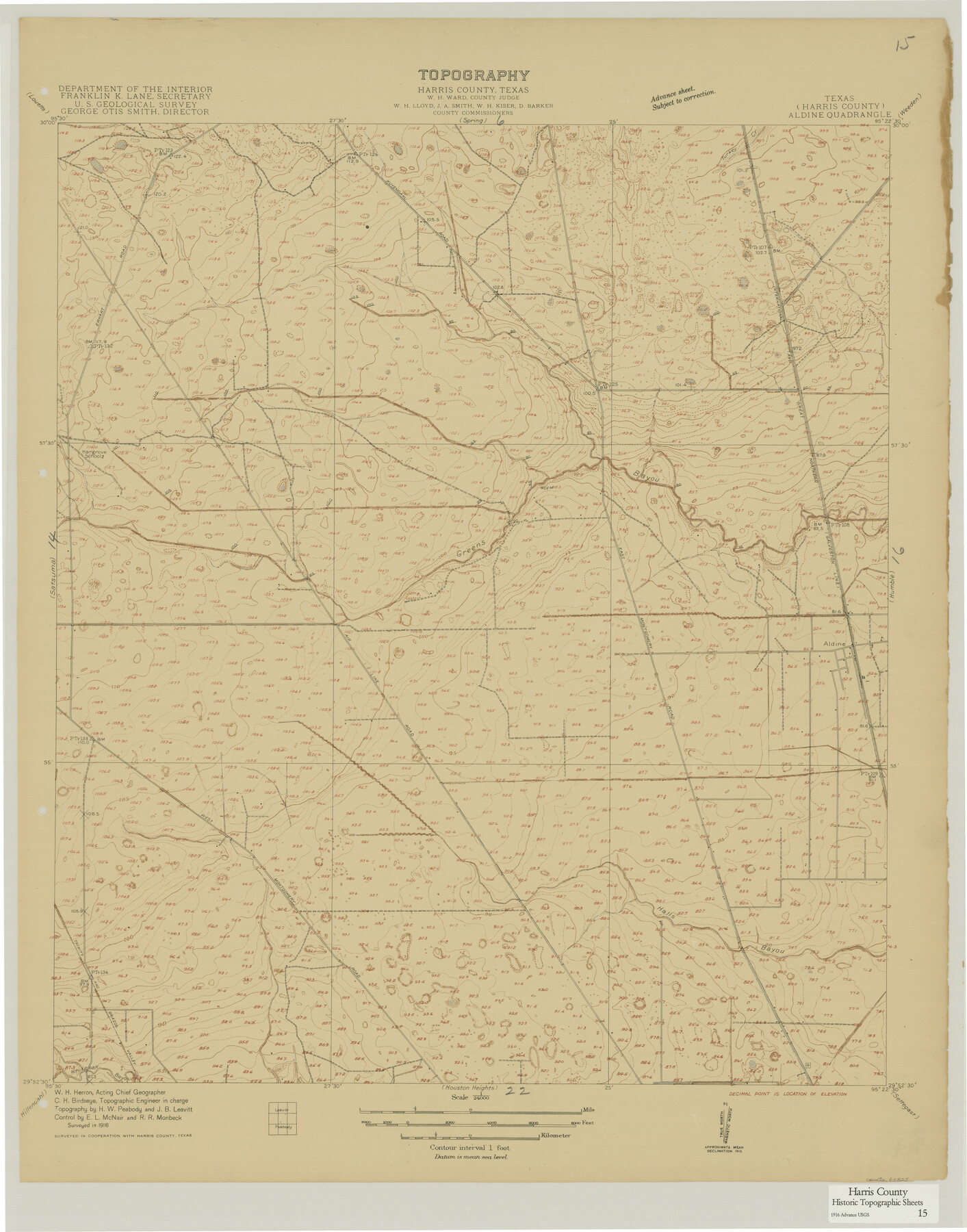
Harris County Historic Topographic 15
Aldine Quadrangle
-
Map/Doc
65825
-
Collection
General Map Collection
-
Object Dates
1916 (Creation Date)
-
People and Organizations
U. S. Geological Survey (Publisher)
-
Counties
Harris
-
Subjects
Topographic
-
Height x Width
29.2 x 22.9 inches
74.2 x 58.2 cm
Part of: General Map Collection
Current Miscellaneous File 7

Print $6.00
- Digital $50.00
Current Miscellaneous File 7
1838
Size 13.8 x 8.5 inches
Map/Doc 73733
Flight Mission No. DCL-6C, Frame 24, Kenedy County

Print $20.00
- Digital $50.00
Flight Mission No. DCL-6C, Frame 24, Kenedy County
1943
Size 18.8 x 22.4 inches
Map/Doc 85881
Parker County Working Sketch 5

Print $20.00
- Digital $50.00
Parker County Working Sketch 5
1952
Map/Doc 71455

Navarro County Working Sketch 3

Print $40.00
- Digital $50.00
Navarro County Working Sketch 3
1921
Size 43.8 x 64.6 inches
Map/Doc 71233

Grid Map Showing Texas, Louisiana, Arkansas, Mississippi and portions of New Mexico, Oklahoma and Tennessee

Print $40.00
- Digital $50.00
Grid Map Showing Texas, Louisiana, Arkansas, Mississippi and portions of New Mexico, Oklahoma and Tennessee
1940
Size 34.2 x 48.1 inches
Map/Doc 3121
Gray's New Map of Texas and the Indian Territory

Print $20.00
- Digital $50.00
Gray's New Map of Texas and the Indian Territory
1876
Size 17.6 x 28.6 inches
Map/Doc 97282
Harris County Sketch File 80a

Print $20.00
- Digital $50.00
Harris County Sketch File 80a
1892
Size 27.8 x 17.6 inches
Map/Doc 11667
Bosque County Working Sketch 10

Print $20.00
- Digital $50.00
Bosque County Working Sketch 10
1944
Size 19.3 x 20.3 inches
Map/Doc 67443
Galveston County Rolled Sketch RB

Print $20.00
- Digital $50.00
Galveston County Rolled Sketch RB
Size 36.0 x 22.2 inches
Map/Doc 5990
Anderson County Working Sketch 38

Print $20.00
- Digital $50.00
Anderson County Working Sketch 38
1985
Size 43.3 x 45.9 inches
Map/Doc 67038
You may also like
Presidio County Rolled Sketch MS

Print $20.00
- Digital $50.00
Presidio County Rolled Sketch MS
1910
Size 31.7 x 18.1 inches
Map/Doc 7411
Smith County Rolled Sketch 6E2

Print $20.00
- Digital $50.00
Smith County Rolled Sketch 6E2
1960
Size 27.6 x 22.7 inches
Map/Doc 10613
A Few Things About Rice as grown along the line of the Sunset Route in Louisiana and Texas

A Few Things About Rice as grown along the line of the Sunset Route in Louisiana and Texas
1904
Map/Doc 96724
Montgomery County Rolled Sketch 26A

Print $20.00
- Digital $50.00
Montgomery County Rolled Sketch 26A
Size 26.9 x 36.8 inches
Map/Doc 6808
Crockett County Working Sketch 47

Print $20.00
- Digital $50.00
Crockett County Working Sketch 47
1935
Size 37.5 x 36.9 inches
Map/Doc 68380
Wichita County Sketch File 12a

Print $10.00
- Digital $50.00
Wichita County Sketch File 12a
1881
Size 14.2 x 8.6 inches
Map/Doc 40077
Township 6 North Range 14 West, North Western District, Louisiana

Print $20.00
- Digital $50.00
Township 6 North Range 14 West, North Western District, Louisiana
1841
Size 19.5 x 24.7 inches
Map/Doc 65863
Wise County Boundary File 96

Print $50.00
- Digital $50.00
Wise County Boundary File 96
Size 9.2 x 3.8 inches
Map/Doc 60130
Maverick County Rolled Sketch 22

Print $20.00
- Digital $50.00
Maverick County Rolled Sketch 22
1963
Size 38.0 x 24.7 inches
Map/Doc 6714
Wise County Sketch File 26

Print $22.00
- Digital $50.00
Wise County Sketch File 26
1855
Size 8.1 x 14.3 inches
Map/Doc 40574
Coleman County Sketch File 45

Print $20.00
- Digital $50.00
Coleman County Sketch File 45
1897
Size 23.9 x 23.8 inches
Map/Doc 11124
Hood County Sketch File 7

Print $6.00
- Digital $50.00
Hood County Sketch File 7
Size 12.9 x 7.9 inches
Map/Doc 26581