Panola County Sketch File 24
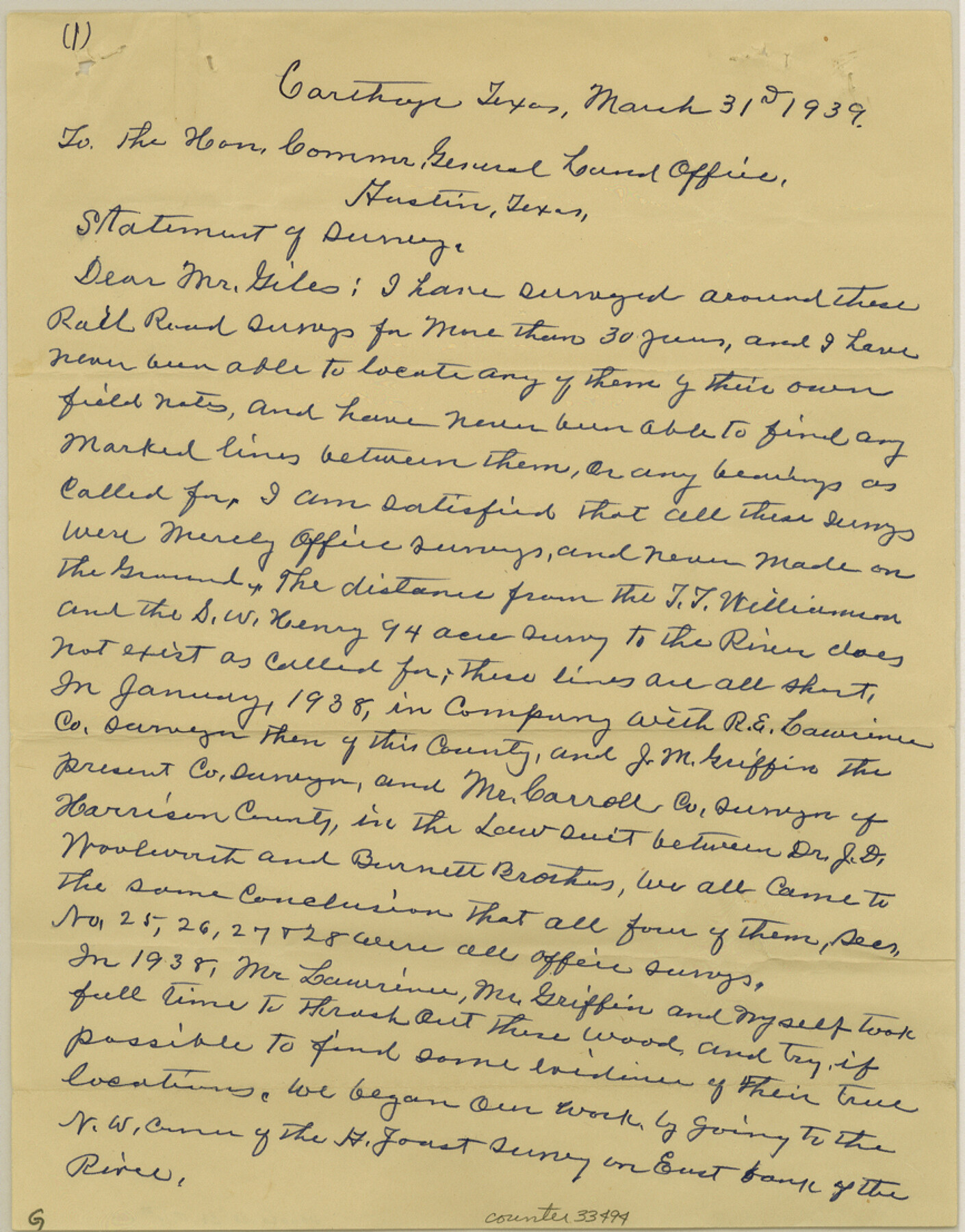
[Statement regarding section 26, T. C. RR. Co. on north county line]
-
Map/Doc
33494
-
Collection
General Map Collection
-
Object Dates
3/31/1939 (Creation Date)
4/3/1939 (File Date)
3/31/1939 (Correspondence Date)
1/1938 (Survey Date)
-
People and Organizations
R.W. Priest (Surveyor/Engineer)
R.E. Lawrince (Surveyor/Engineer)
J.M. Griffin (Surveyor/Engineer)
McCarroll (Surveyor/Engineer)
-
Counties
Panola
-
Subjects
Surveying Sketch File
-
Height x Width
11.1 x 8.7 inches
28.2 x 22.1 cm
-
Medium
paper, manuscript
-
Features
Sabine River
Part of: General Map Collection
Fisher County Working Sketch 11

Print $20.00
- Digital $50.00
Fisher County Working Sketch 11
1952
Size 21.2 x 35.1 inches
Map/Doc 69145
Township No. 2 South Range No. 24 West of the Indian Meridian

Print $20.00
- Digital $50.00
Township No. 2 South Range No. 24 West of the Indian Meridian
1875
Size 19.3 x 24.4 inches
Map/Doc 75174
Pecos County Working Sketch 49

Print $20.00
- Digital $50.00
Pecos County Working Sketch 49
1947
Size 22.4 x 15.3 inches
Map/Doc 71521
Montgomery County Working Sketch 46

Print $20.00
- Digital $50.00
Montgomery County Working Sketch 46
1957
Size 25.6 x 28.1 inches
Map/Doc 71153
Culberson County Sketch File 4a

Print $10.00
- Digital $50.00
Culberson County Sketch File 4a
Size 9.2 x 7.9 inches
Map/Doc 20131
Flight Mission No. DQN-2K, Frame 76, Calhoun County

Print $20.00
- Digital $50.00
Flight Mission No. DQN-2K, Frame 76, Calhoun County
1953
Size 18.8 x 22.3 inches
Map/Doc 84268
Presidio County Rolled Sketch 93A

Print $20.00
- Digital $50.00
Presidio County Rolled Sketch 93A
Size 29.6 x 28.2 inches
Map/Doc 7379
Trinity River, Balltown Sheet/Pilot Grove Creek

Print $20.00
- Digital $50.00
Trinity River, Balltown Sheet/Pilot Grove Creek
1916
Size 36.9 x 27.5 inches
Map/Doc 65195
Part of Laguna Madre in Kenedy and Willacy Counties, showing Subdivision for Mineral Development

Print $40.00
- Digital $50.00
Part of Laguna Madre in Kenedy and Willacy Counties, showing Subdivision for Mineral Development
1946
Size 49.1 x 30.0 inches
Map/Doc 1924
Midland County Rolled Sketch 14

Print $20.00
- Digital $50.00
Midland County Rolled Sketch 14
1996
Size 21.3 x 26.7 inches
Map/Doc 6769
Wharton County Sketch File 4a

Print $4.00
- Digital $50.00
Wharton County Sketch File 4a
1876
Size 12.7 x 8.1 inches
Map/Doc 39919
Collingsworth County Working Sketch 6

Print $20.00
- Digital $50.00
Collingsworth County Working Sketch 6
1990
Size 37.7 x 41.8 inches
Map/Doc 68094
You may also like
Flight Mission No. BQR-13K, Frame 27, Brazoria County

Print $20.00
- Digital $50.00
Flight Mission No. BQR-13K, Frame 27, Brazoria County
1952
Size 18.7 x 22.5 inches
Map/Doc 84075

Shelby County Working Sketch 1

Print $20.00
- Digital $50.00
Shelby County Working Sketch 1
1917
Size 26.2 x 30.0 inches
Map/Doc 63854
Map showing the route of the Corpus Christi, San Diego & Rio Grande Railroad, and its connections

Print $20.00
- Digital $50.00
Map showing the route of the Corpus Christi, San Diego & Rio Grande Railroad, and its connections
1880
Size 11.9 x 9.1 inches
Map/Doc 96765
Reagan County Sketch File 23

Print $24.00
- Digital $50.00
Reagan County Sketch File 23
1939
Size 11.3 x 8.8 inches
Map/Doc 35016
Terrell County Rolled Sketch 57

Print $20.00
- Digital $50.00
Terrell County Rolled Sketch 57
1986
Size 33.0 x 25.2 inches
Map/Doc 7974
Galveston County NRC Article 33.136 Sketch 67

Print $28.00
- Digital $50.00
Galveston County NRC Article 33.136 Sketch 67
2011
Size 17.0 x 24.0 inches
Map/Doc 93391
[Sketch for Mineral Application 16700 - Pecos River Bed]
![2807, [Sketch for Mineral Application 16700 - Pecos River Bed], General Map Collection](https://historictexasmaps.com/wmedia_w700/maps/2807.tif.jpg)
Print $20.00
- Digital $50.00
[Sketch for Mineral Application 16700 - Pecos River Bed]
1927
Size 32.9 x 15.3 inches
Map/Doc 2807
Lynn County Sketch File 13

Print $18.00
- Digital $50.00
Lynn County Sketch File 13
1903
Size 10.6 x 8.1 inches
Map/Doc 30482
Harris County Sketch File 102

Print $163.00
- Digital $50.00
Harris County Sketch File 102
1985
Size 11.4 x 8.9 inches
Map/Doc 25915
Coast Chart No. 212 - From Latitude 26° 33' to the Rio Grande Texas

Print $20.00
- Digital $50.00
Coast Chart No. 212 - From Latitude 26° 33' to the Rio Grande Texas
1886
Size 27.4 x 18.2 inches
Map/Doc 72829
[Bastrop District]
![16941, [Bastrop District], General Map Collection](https://historictexasmaps.com/wmedia_w700/maps/16941-1.tif.jpg)
Print $40.00
- Digital $50.00
[Bastrop District]
1838
Size 67.3 x 44.2 inches
Map/Doc 16941