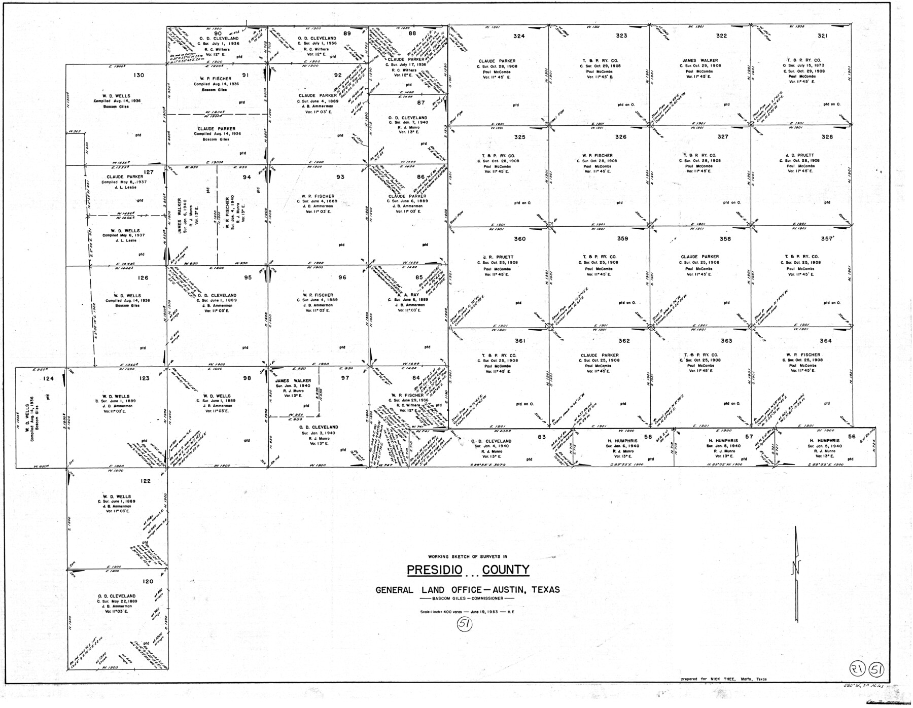
Presidio County Working Sketch 51
-
Map/Doc
71728
-
Collection
General Map Collection
-
Object Dates
6/19/1953 (Creation Date)
-
People and Organizations
Herman Forbes (Draftsman)
-
Counties
Presidio
-
Subjects
Surveying Working Sketch
-
Height x Width
33.4 x 43.1 inches
84.8 x 109.5 cm
-
Scale
1" = 400 varas
Part of: General Map Collection
Val Verde County Working Sketch 34

Print $20.00
- Digital $50.00
Val Verde County Working Sketch 34
1940
Size 33.7 x 27.9 inches
Map/Doc 72169

Jefferson County Working Sketch Graphic Index

Print $20.00
- Digital $50.00
Jefferson County Working Sketch Graphic Index
1978
Size 47.1 x 41.4 inches
Map/Doc 76595
Harris County Working Sketch 13

Print $20.00
- Digital $50.00
Harris County Working Sketch 13
1915
Size 19.9 x 11.0 inches
Map/Doc 65905
Map of section no. 7 of a survey of Padre Island made for the Office of the Attorney General of the State of Texas

Print $40.00
- Digital $50.00
Map of section no. 7 of a survey of Padre Island made for the Office of the Attorney General of the State of Texas
1941
Size 56.3 x 41.2 inches
Map/Doc 2263
Flight Mission No. DQO-8K, Frame 8, Galveston County

Print $20.00
- Digital $50.00
Flight Mission No. DQO-8K, Frame 8, Galveston County
1952
Size 18.8 x 22.5 inches
Map/Doc 85131
Map of Titus County

Print $20.00
- Digital $50.00
Map of Titus County
1860
Size 20.9 x 21.8 inches
Map/Doc 4081
Martin County Working Sketch 15

Print $20.00
- Digital $50.00
Martin County Working Sketch 15
1975
Size 23.9 x 19.5 inches
Map/Doc 70833
Runnels County Rolled Sketch 51

Print $20.00
- Digital $50.00
Runnels County Rolled Sketch 51
Size 26.1 x 34.3 inches
Map/Doc 7536
Duval County Sketch File 81

Print $18.00
- Digital $50.00
Duval County Sketch File 81
Size 11.2 x 8.8 inches
Map/Doc 21507
Lampasas County Working Sketch 15

Print $20.00
- Digital $50.00
Lampasas County Working Sketch 15
1975
Size 28.5 x 23.8 inches
Map/Doc 70292
Presidio County Rolled Sketch 70

Print $20.00
- Digital $50.00
Presidio County Rolled Sketch 70
1927
Size 37.1 x 13.9 inches
Map/Doc 7360
You may also like
[Surveys in the Bexar District along Borrego Creek prepared by the Deputy Surveyor]
![96, [Surveys in the Bexar District along Borrego Creek prepared by the Deputy Surveyor], General Map Collection](https://historictexasmaps.com/wmedia_w700/maps/96.tif.jpg)
Print $2.00
- Digital $50.00
[Surveys in the Bexar District along Borrego Creek prepared by the Deputy Surveyor]
1847
Size 7.7 x 7.2 inches
Map/Doc 96
Liberty County Working Sketch 28

Print $20.00
- Digital $50.00
Liberty County Working Sketch 28
1942
Size 22.4 x 23.2 inches
Map/Doc 70487
Real County Working Sketch 14

Print $20.00
- Digital $50.00
Real County Working Sketch 14
1933
Size 30.2 x 30.5 inches
Map/Doc 71906
Ochiltree County Boundary File 4

Print $4.00
- Digital $50.00
Ochiltree County Boundary File 4
Size 11.1 x 8.7 inches
Map/Doc 57682
Limestone County Working Sketch 1

Print $20.00
- Digital $50.00
Limestone County Working Sketch 1
Size 15.4 x 13.0 inches
Map/Doc 70551
Fort Bend County Boundary File 1

Print $80.00
- Digital $50.00
Fort Bend County Boundary File 1
Size 25.0 x 69.7 inches
Map/Doc 53553
Colorado County Sketch File 3b

Print $4.00
- Digital $50.00
Colorado County Sketch File 3b
Size 7.0 x 8.2 inches
Map/Doc 18913
General Highway Map, Madison County, Texas

Print $20.00
General Highway Map, Madison County, Texas
1940
Size 18.3 x 24.5 inches
Map/Doc 79183
Caldwell County

Print $20.00
- Digital $50.00
Caldwell County
1935
Size 36.1 x 40.3 inches
Map/Doc 77227
El Paso County Working Sketch 39

Print $20.00
- Digital $50.00
El Paso County Working Sketch 39
1984
Size 45.7 x 37.1 inches
Map/Doc 69061
G & H Blocks, Gaines County, Texas Resurvey

Print $40.00
- Digital $50.00
G & H Blocks, Gaines County, Texas Resurvey
1915
Size 58.1 x 33.7 inches
Map/Doc 89667
Nueces County Rolled Sketch 80

Print $58.00
Nueces County Rolled Sketch 80
1982
Size 24.2 x 36.7 inches
Map/Doc 6952