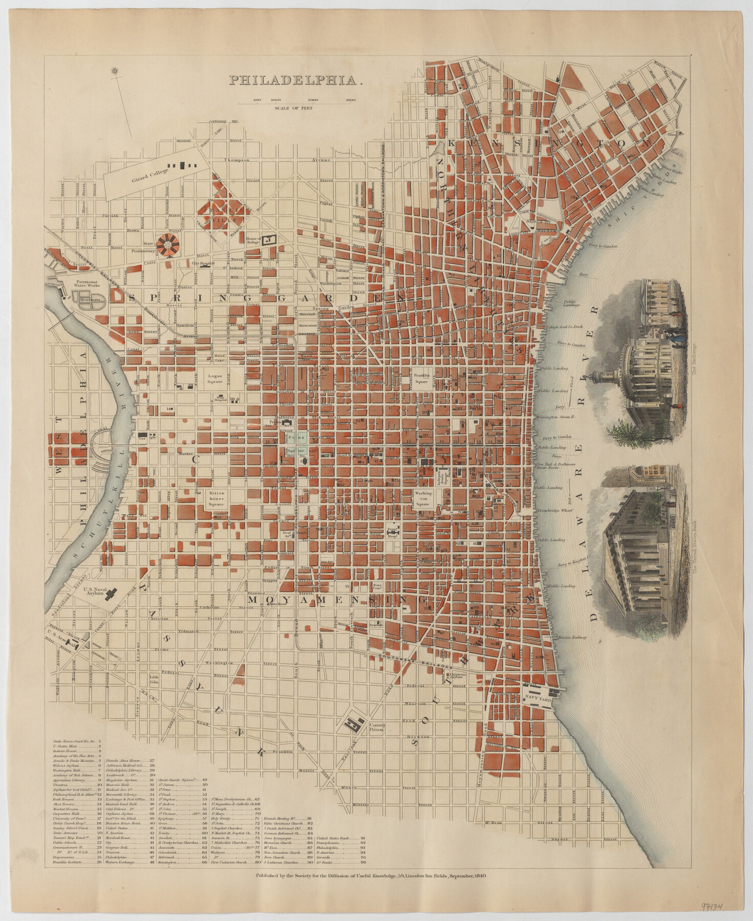
Philadelphia
-
Map/Doc
97134
-
Collection
General Map Collection
-
Object Dates
9/1840 (Creation Date)
-
People and Organizations
Society for the Diffusion of Useful Knowledge (Publisher)
-
Subjects
City
-
Height x Width
16.7 x 13.6 inches
42.4 x 34.5 cm
-
Medium
paper, etching/engraving/lithograph
Part of: General Map Collection
Colonization and Trade in the New World

Colonization and Trade in the New World
1977
Size 23.1 x 30.3 inches
Map/Doc 96835
Goliad County Working Sketch 17

Print $20.00
- Digital $50.00
Goliad County Working Sketch 17
1949
Size 21.8 x 22.2 inches
Map/Doc 63207
Zavala County Working Sketch 12

Print $20.00
- Digital $50.00
Zavala County Working Sketch 12
1956
Size 31.5 x 30.2 inches
Map/Doc 62087
Copy of Surveyor's Field Book, Morris Browning - In Blocks 7, 5 & 4, I&GNRRCo., Hutchinson and Carson Counties, Texas

Print $2.00
- Digital $50.00
Copy of Surveyor's Field Book, Morris Browning - In Blocks 7, 5 & 4, I&GNRRCo., Hutchinson and Carson Counties, Texas
1888
Size 7.0 x 8.8 inches
Map/Doc 62278
El Paso County State Real Property Sketch 2

Print $20.00
- Digital $50.00
El Paso County State Real Property Sketch 2
2007
Size 24.4 x 36.2 inches
Map/Doc 88671
Chambers County Rolled Sketch 31

Print $20.00
- Digital $50.00
Chambers County Rolled Sketch 31
1952
Size 32.3 x 32.0 inches
Map/Doc 8620
Brazoria County Sketch File 21

Print $4.00
- Digital $50.00
Brazoria County Sketch File 21
Size 8.3 x 7.5 inches
Map/Doc 15016
Matagorda Light to Aransas Pass

Print $20.00
- Digital $50.00
Matagorda Light to Aransas Pass
1924
Size 35.9 x 44.6 inches
Map/Doc 73391
Flight Mission No. CGI-1N, Frame 220, Cameron County

Print $20.00
- Digital $50.00
Flight Mission No. CGI-1N, Frame 220, Cameron County
1955
Size 18.5 x 22.1 inches
Map/Doc 84529
Map of Terry County

Print $20.00
- Digital $50.00
Map of Terry County
1901
Size 43.1 x 39.8 inches
Map/Doc 16892
La Salle County Working Sketch 8

Print $20.00
- Digital $50.00
La Salle County Working Sketch 8
1922
Size 19.0 x 18.3 inches
Map/Doc 70309
Brewster County Sketch File N-24

Print $40.00
- Digital $50.00
Brewster County Sketch File N-24
Size 23.9 x 16.4 inches
Map/Doc 10970
You may also like
[Map showing Jno. H. Gibson Block D]
![92001, [Map showing Jno. H. Gibson Block D], Twichell Survey Records](https://historictexasmaps.com/wmedia_w700/maps/92001-1.tif.jpg)
Print $20.00
- Digital $50.00
[Map showing Jno. H. Gibson Block D]
Size 17.9 x 15.0 inches
Map/Doc 92001
Section 21, Block A, Sylvan Sanders Survey

Print $20.00
- Digital $50.00
Section 21, Block A, Sylvan Sanders Survey
1952
Size 24.6 x 16.6 inches
Map/Doc 92723
Township 11 South Range 13 West and 14 West, South Western District, Louisiana

Print $20.00
- Digital $50.00
Township 11 South Range 13 West and 14 West, South Western District, Louisiana
1838
Size 19.6 x 24.6 inches
Map/Doc 65854
Flight Mission No. DAG-22K, Frame 73, Matagorda County

Print $20.00
- Digital $50.00
Flight Mission No. DAG-22K, Frame 73, Matagorda County
1953
Size 18.7 x 22.4 inches
Map/Doc 86460
Reeves County Working Sketch 23

Print $40.00
- Digital $50.00
Reeves County Working Sketch 23
1966
Size 31.6 x 54.5 inches
Map/Doc 63466
Map accompanying report of scout made by 2nd Lt. F. de I. Carrington. 1st Infantry

Print $20.00
- Digital $50.00
Map accompanying report of scout made by 2nd Lt. F. de I. Carrington. 1st Infantry
1881
Size 22.2 x 18.0 inches
Map/Doc 65407
Reeves County Sketch File 14

Print $4.00
- Digital $50.00
Reeves County Sketch File 14
1872
Size 8.0 x 12.7 inches
Map/Doc 35192

Motley County Sketch File 9a (N)

Print $4.00
- Digital $50.00
Motley County Sketch File 9a (N)
1885
Size 14.2 x 8.6 inches
Map/Doc 32024
Edwards County Working Sketch 60

Print $20.00
- Digital $50.00
Edwards County Working Sketch 60
1954
Size 20.5 x 43.7 inches
Map/Doc 68936
Flight Mission No. DCL-4C, Frame 120, Kenedy County

Print $20.00
- Digital $50.00
Flight Mission No. DCL-4C, Frame 120, Kenedy County
1943
Size 18.6 x 22.5 inches
Map/Doc 85819
Parker Place Addition

Print $3.00
- Digital $50.00
Parker Place Addition
1952
Size 11.8 x 17.9 inches
Map/Doc 92414