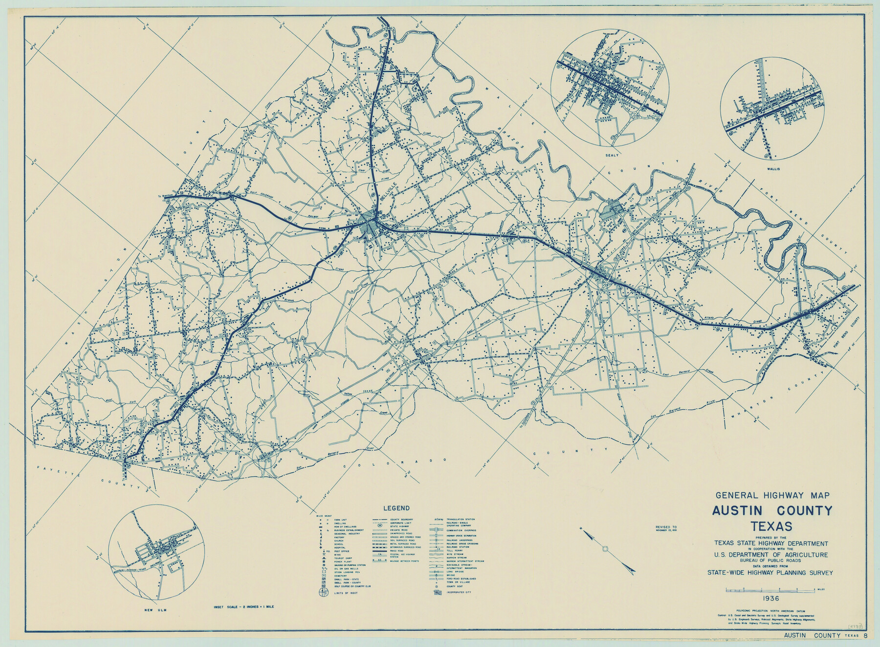
General Highway Map, Austin County, Texas
-
Map/Doc
79009
-
Collection
Texas State Library and Archives
-
Object Dates
11/23/1939 (Creation Date)
-
People and Organizations
Texas State Highway Department (Publisher)
-
Counties
Austin
-
Subjects
County
-
Height x Width
18.4 x 25.0 inches
46.7 x 63.5 cm
-
Comments
Prints available courtesy of the Texas State Library and Archives.
More info can be found here: TSLAC Map 04788
Part of: Texas State Library and Archives
General Highway Map, Scurry County, Texas

Print $20.00
General Highway Map, Scurry County, Texas
1961
Size 18.1 x 24.8 inches
Map/Doc 79650
General Highway Map, Johnson County, Texas

Print $20.00
General Highway Map, Johnson County, Texas
1940
Size 18.3 x 24.8 inches
Map/Doc 79149
General Highway Map, Gonzales County, Texas

Print $20.00
General Highway Map, Gonzales County, Texas
1940
Size 18.6 x 25.0 inches
Map/Doc 79102
General Highway Map, Hall County, Texas

Print $20.00
General Highway Map, Hall County, Texas
1961
Size 18.2 x 24.6 inches
Map/Doc 79495
General Highway Map, Zapata County, Texas

Print $20.00
General Highway Map, Zapata County, Texas
1961
Size 18.2 x 24.8 inches
Map/Doc 79721
General Highway Map, Montague County, Texas

Print $20.00
General Highway Map, Montague County, Texas
1940
Size 24.9 x 18.3 inches
Map/Doc 79201
General Highway Map, Cottle County, Texas

Print $20.00
General Highway Map, Cottle County, Texas
1961
Size 18.1 x 24.6 inches
Map/Doc 79423
General Highway Map. Detail of Cities and Towns in Lubbock County, Texas [Lubbock and vicinity]
![79181, General Highway Map. Detail of Cities and Towns in Lubbock County, Texas [Lubbock and vicinity], Texas State Library and Archives](https://historictexasmaps.com/wmedia_w700/maps/79181.tif.jpg)
Print $20.00
General Highway Map. Detail of Cities and Towns in Lubbock County, Texas [Lubbock and vicinity]
1940
Size 18.3 x 24.8 inches
Map/Doc 79181
Map of the United States and their Territories between the Mississippi and the Pacific Ocean and Part of Mexico

Print $20.00
Map of the United States and their Territories between the Mississippi and the Pacific Ocean and Part of Mexico
1857
Size 21.8 x 24.7 inches
Map/Doc 79724
General Highway Map, Robertson County, Texas

Print $20.00
General Highway Map, Robertson County, Texas
1961
Size 18.1 x 24.4 inches
Map/Doc 79641
General Highway Map, Fort Bend County, Texas

Print $20.00
General Highway Map, Fort Bend County, Texas
1939
Size 18.6 x 25.2 inches
Map/Doc 79093
General Highway Map, Midland County, Texas

Print $20.00
General Highway Map, Midland County, Texas
1940
Size 18.2 x 24.5 inches
Map/Doc 79197
You may also like
Throckmorton County Sketch File 2

Print $20.00
- Digital $50.00
Throckmorton County Sketch File 2
Size 22.1 x 26.2 inches
Map/Doc 12431
La Salle County Working Sketch 20

Print $20.00
- Digital $50.00
La Salle County Working Sketch 20
1941
Size 23.7 x 29.9 inches
Map/Doc 70321
Corpus Christi Bay

Print $20.00
- Digital $50.00
Corpus Christi Bay
1973
Size 36.6 x 47.7 inches
Map/Doc 73474
Gaines County Rolled Sketch 15C

Print $40.00
- Digital $50.00
Gaines County Rolled Sketch 15C
Size 128.4 x 22.8 inches
Map/Doc 75928
La Salle County Working Sketch 56

Print $20.00
- Digital $50.00
La Salle County Working Sketch 56
2012
Size 25.5 x 23.0 inches
Map/Doc 93277
Hemphill County Sketch File 10

Print $6.00
- Digital $50.00
Hemphill County Sketch File 10
1903
Size 14.3 x 8.8 inches
Map/Doc 26315

Terrell County Working Sketch 26

Print $20.00
- Digital $50.00
Terrell County Working Sketch 26
1943
Size 17.5 x 14.0 inches
Map/Doc 62176
Bee County Working Sketch 22

Print $20.00
- Digital $50.00
Bee County Working Sketch 22
1983
Size 37.9 x 37.2 inches
Map/Doc 67272
Bandera County Working Sketch 36

Print $20.00
- Digital $50.00
Bandera County Working Sketch 36
1966
Size 22.5 x 29.5 inches
Map/Doc 67632
Matagorda County Sketch File 34

Print $6.00
- Digital $50.00
Matagorda County Sketch File 34
1950
Size 14.3 x 8.8 inches
Map/Doc 30820
[Nueces Bay, Mustang Island and Padre Island]
![73465, [Nueces Bay, Mustang Island and Padre Island], General Map Collection](https://historictexasmaps.com/wmedia_w700/maps/73465.tif.jpg)
Print $4.00
- Digital $50.00
[Nueces Bay, Mustang Island and Padre Island]
Size 18.1 x 24.7 inches
Map/Doc 73465