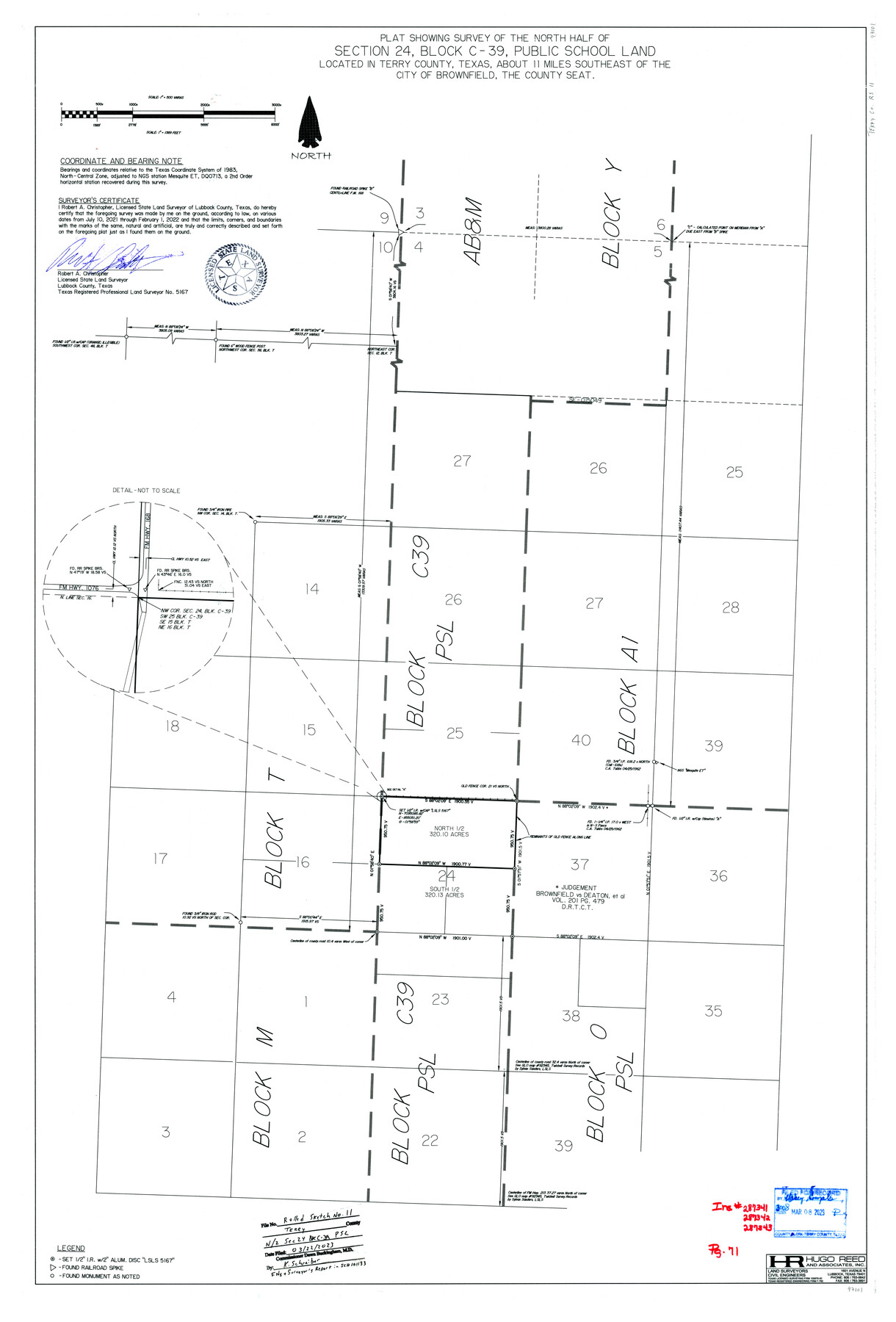
Terry County Rolled Sketch 11
Plat showing survey of the north half of section 24, Block C-39, Public School Land located in Terry County, Texas
-
Map/Doc
97101
-
Collection
General Map Collection
-
Object Dates
3/22/2023 (File Date)
2/1/2022 (Creation Date)
7/10/2021 - 2/1/2022 (Survey Date)
-
People and Organizations
Robert A. Christopher (Surveyor/Engineer)
-
Counties
Terry
-
Subjects
Surveying Rolled Sketch
-
Height x Width
37.1 x 25.1 inches
94.2 x 63.8 cm
-
Medium
mylar, print
-
Scale
1" = 500 varas
-
Comments
For field notes and surveyor's report see School File 101133.
Part of: General Map Collection
Schleicher County Sketch File 42

Print $40.00
- Digital $50.00
Schleicher County Sketch File 42
1963
Size 16.3 x 14.4 inches
Map/Doc 36546
Hamilton County

Print $20.00
- Digital $50.00
Hamilton County
1916
Size 41.4 x 40.5 inches
Map/Doc 66851
Ochiltree County Boundary File 7

Print $20.00
- Digital $50.00
Ochiltree County Boundary File 7
Size 36.1 x 9.3 inches
Map/Doc 57715


Hutchinson County Boundary File 1a

Print $10.00
- Digital $50.00
Hutchinson County Boundary File 1a
Size 7.3 x 8.7 inches
Map/Doc 55297
Flight Mission No. CLL-1N, Frame 88, Willacy County

Print $20.00
- Digital $50.00
Flight Mission No. CLL-1N, Frame 88, Willacy County
1954
Size 18.4 x 22.1 inches
Map/Doc 87034
Flight Mission No. CRC-2R, Frame 180, Chambers County

Print $20.00
- Digital $50.00
Flight Mission No. CRC-2R, Frame 180, Chambers County
1956
Size 18.7 x 22.4 inches
Map/Doc 84758
Copy of Surveyor's Field Book, Morris Browning - In Blocks 7, 5 & 4, I&GNRRCo., Hutchinson and Carson Counties, Texas

Print $2.00
- Digital $50.00
Copy of Surveyor's Field Book, Morris Browning - In Blocks 7, 5 & 4, I&GNRRCo., Hutchinson and Carson Counties, Texas
1888
Size 6.9 x 8.8 inches
Map/Doc 62275
Kenedy County Sketch File 1

Print $68.00
- Digital $50.00
Kenedy County Sketch File 1
1950
Size 14.2 x 8.8 inches
Map/Doc 28739
Nueces County Sketch File 58

Print $162.00
- Digital $50.00
Nueces County Sketch File 58
1981
Size 11.2 x 8.5 inches
Map/Doc 32920
McLennan County Sketch File 25

Print $2.00
- Digital $50.00
McLennan County Sketch File 25
Size 8.8 x 12.3 inches
Map/Doc 31299
You may also like
Flight Mission No. DCL-3C, Frame 155, Kenedy County

Print $20.00
- Digital $50.00
Flight Mission No. DCL-3C, Frame 155, Kenedy County
1943
Size 18.6 x 22.4 inches
Map/Doc 85803
Garza County Sketch File C2

Print $6.00
- Digital $50.00
Garza County Sketch File C2
1900
Size 10.3 x 8.4 inches
Map/Doc 24019
Duval County Rolled Sketch 11

Print $20.00
- Digital $50.00
Duval County Rolled Sketch 11
Size 20.4 x 30.1 inches
Map/Doc 5733
Controlled Mosaic by Jack Amman Photogrammetric Engineers, Inc - Sheet 23

Print $20.00
- Digital $50.00
Controlled Mosaic by Jack Amman Photogrammetric Engineers, Inc - Sheet 23
1954
Size 20.0 x 24.0 inches
Map/Doc 83474
Hamilton County Working Sketch 1

Print $20.00
- Digital $50.00
Hamilton County Working Sketch 1
1914
Size 17.7 x 17.8 inches
Map/Doc 63339
Chambers County Rolled Sketch 30

Print $20.00
- Digital $50.00
Chambers County Rolled Sketch 30
1952
Size 26.8 x 37.8 inches
Map/Doc 5431
Hardin County Sketch File 33

Print $20.00
- Digital $50.00
Hardin County Sketch File 33
Size 25.4 x 35.4 inches
Map/Doc 11632
[Atlas A, Table of Contents, part 2]
![82085, [Atlas A, Table of Contents, part 2], General Map Collection](https://historictexasmaps.com/wmedia_w700/maps/82085.tif.jpg)
Print $2.00
- Digital $50.00
[Atlas A, Table of Contents, part 2]
Size 7.0 x 11.8 inches
Map/Doc 82085
Kendall County Working Sketch 22

Print $20.00
- Digital $50.00
Kendall County Working Sketch 22
1971
Size 41.6 x 34.7 inches
Map/Doc 66694
Ownership Map of Val Verde County

Print $20.00
- Digital $50.00
Ownership Map of Val Verde County
1927
Size 32.7 x 36.9 inches
Map/Doc 92847
Val Verde County Working Sketch 41

Print $20.00
- Digital $50.00
Val Verde County Working Sketch 41
1943
Size 27.8 x 30.2 inches
Map/Doc 72176
Houston County Working Sketch 24

Print $40.00
- Digital $50.00
Houston County Working Sketch 24
1983
Size 43.9 x 77.2 inches
Map/Doc 66254