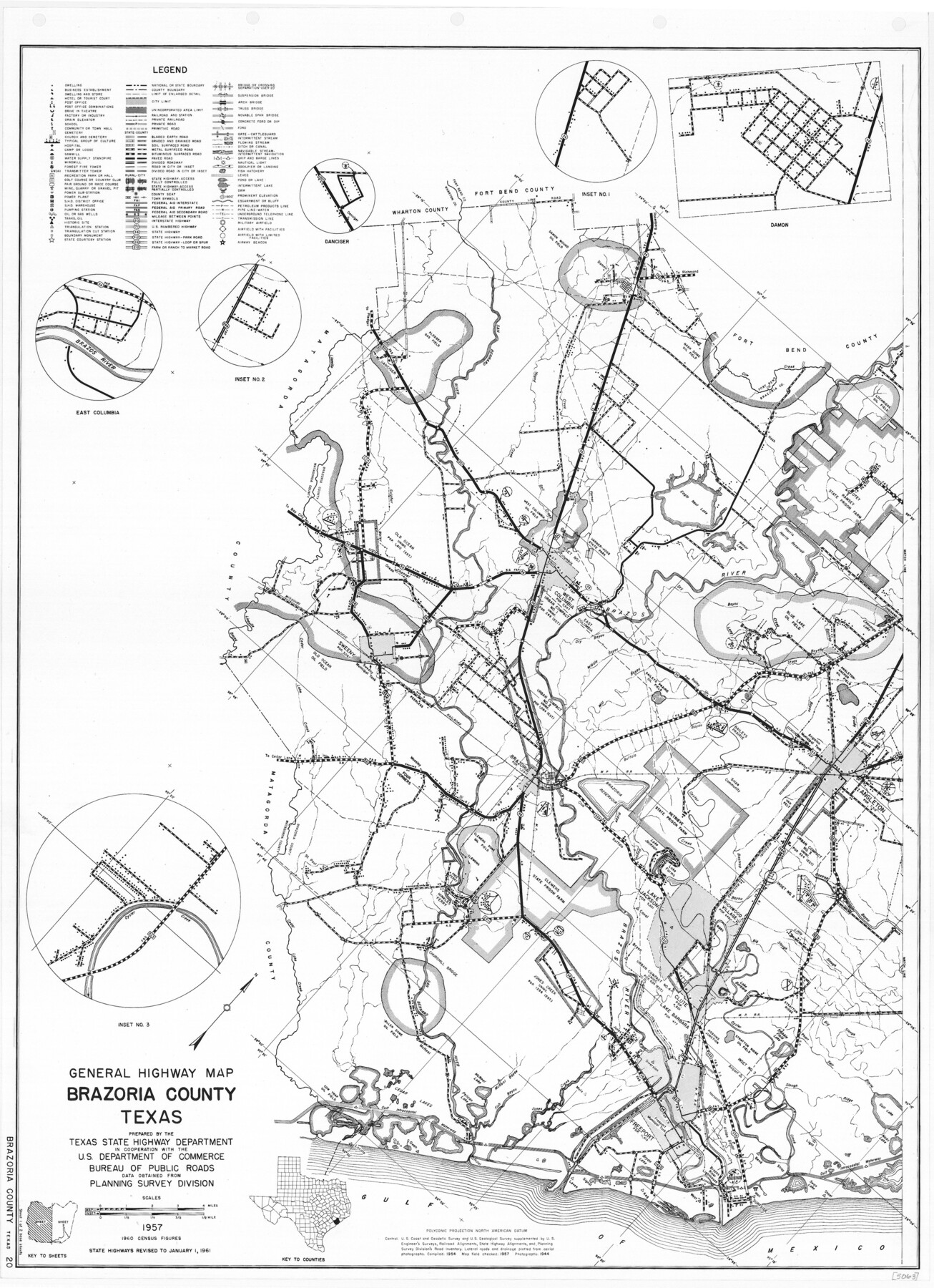
General Highway Map, Brazoria County, Texas
-
Map/Doc
79382
-
Collection
Texas State Library and Archives
-
Object Dates
1961 (Creation Date)
-
People and Organizations
Texas State Highway Department (Publisher)
-
Counties
Brazoria
-
Subjects
County
-
Height x Width
25.0 x 18.2 inches
63.5 x 46.2 cm
-
Comments
Prints available courtesy of the Texas State Library and Archives.
More info can be found here: TSLAC Map 05063
Part of: Texas State Library and Archives
General Highway Map, Goliad County, Texas

Print $20.00
General Highway Map, Goliad County, Texas
1940
Size 18.7 x 25.1 inches
Map/Doc 79101
General Highway Map, Brazoria County, Texas

Print $20.00
General Highway Map, Brazoria County, Texas
1939
Size 18.6 x 25.0 inches
Map/Doc 79024
General Highway Map, Lee County, Texas

Print $20.00
General Highway Map, Lee County, Texas
1961
Size 18.4 x 24.6 inches
Map/Doc 79567
General Highway Map, Lamar County, Texas

Print $20.00
General Highway Map, Lamar County, Texas
1940
Size 24.8 x 18.5 inches
Map/Doc 79167
General Highway Map, Kent County, Texas

Print $20.00
General Highway Map, Kent County, Texas
1961
Size 18.2 x 24.6 inches
Map/Doc 79550
General Soil Map of Texas

Print $20.00
General Soil Map of Texas
1935
Size 35.2 x 46.4 inches
Map/Doc 76309
General Highway Map, Gonzales County, Texas

Print $20.00
General Highway Map, Gonzales County, Texas
1940
Size 18.6 x 25.0 inches
Map/Doc 79102

General Highway Map, Grimes County, Texas

Print $20.00
General Highway Map, Grimes County, Texas
1961
Size 24.8 x 18.1 inches
Map/Doc 79490
Stanford's Map of the Seat of War in America

Print $40.00
Stanford's Map of the Seat of War in America
1861
Size 52.2 x 45.7 inches
Map/Doc 76231
Stremme General Land Office Drawings, front view

Print $20.00
Stremme General Land Office Drawings, front view
Size 14.0 x 20.8 inches
Map/Doc 79738
General Highway Map, Loving County, Texas

Print $20.00
General Highway Map, Loving County, Texas
1940
Size 18.3 x 24.8 inches
Map/Doc 79179
You may also like
Roberts County Working Sketch 9

Print $20.00
- Digital $50.00
Roberts County Working Sketch 9
1964
Size 24.3 x 36.5 inches
Map/Doc 63535
Harris County Historic Topographic 1

Print $20.00
- Digital $50.00
Harris County Historic Topographic 1
1916
Size 29.3 x 22.7 inches
Map/Doc 65811
McLennan County Boundary File 4

Print $12.00
- Digital $50.00
McLennan County Boundary File 4
Size 8.8 x 7.5 inches
Map/Doc 56973
Carson County Boundary File 9

Print $74.00
- Digital $50.00
Carson County Boundary File 9
Size 9.0 x 8.9 inches
Map/Doc 51175
Clay County Sketch File 12

Print $4.00
- Digital $50.00
Clay County Sketch File 12
1873
Size 13.0 x 8.2 inches
Map/Doc 18411
Flight Mission No. CRC-4R, Frame 161, Chambers County

Print $20.00
- Digital $50.00
Flight Mission No. CRC-4R, Frame 161, Chambers County
1956
Size 18.5 x 22.3 inches
Map/Doc 84920
Webb County Rolled Sketch 74

Print $20.00
- Digital $50.00
Webb County Rolled Sketch 74
1982
Size 40.7 x 31.9 inches
Map/Doc 10131
Anderson County

Print $40.00
- Digital $50.00
Anderson County
1942
Size 52.9 x 47.9 inches
Map/Doc 66702
Mme. Begue and her Recipes - Old Creole Cookery

Mme. Begue and her Recipes - Old Creole Cookery
1900
Size 5.9 x 3.9 inches
Map/Doc 96607
[Sketch for Mineral Application 31137 - Colorado River, W. A. Wagner]
![65634, [Sketch for Mineral Application 31137 - Colorado River, W. A. Wagner], General Map Collection](https://historictexasmaps.com/wmedia_w700/maps/65634.tif.jpg)
Print $40.00
- Digital $50.00
[Sketch for Mineral Application 31137 - Colorado River, W. A. Wagner]
1928
Size 39.6 x 126.2 inches
Map/Doc 65634
Maps showing Arkansas Central, the Helena & Corinth, and the Pine Bluff & Southwestern Railroads together forming the Texas & Northeastern Railway.

Print $20.00
Maps showing Arkansas Central, the Helena & Corinth, and the Pine Bluff & Southwestern Railroads together forming the Texas & Northeastern Railway.
1872
Size 26.8 x 29.1 inches
Map/Doc 93609
Pecos County Rolled Sketch 126

Print $20.00
- Digital $50.00
Pecos County Rolled Sketch 126
1948
Size 42.5 x 38.4 inches
Map/Doc 9724