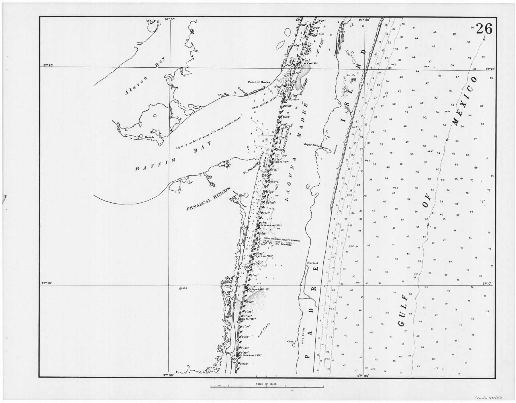
Navigation Maps of Gulf Intracoastal Waterway, Port Arthur to Brownsville, Texas
K-7-68
-
Map/Doc
65446
-
Collection
General Map Collection
-
Object Dates
1951 (Creation Date)
-
People and Organizations
Corps of Engineers (Publisher)
-
Counties
Kenedy Kleberg
-
Subjects
Intracoastal Waterways
-
Height x Width
16.7 x 21.4 inches
42.4 x 54.4 cm
Part of: General Map Collection
Brooks County Working Sketch 1

Print $3.00
- Digital $50.00
Brooks County Working Sketch 1
Size 9.1 x 9.3 inches
Map/Doc 67785
Jasper County Rolled Sketch 2

Print $20.00
- Digital $50.00
Jasper County Rolled Sketch 2
1941
Size 37.9 x 24.1 inches
Map/Doc 6349
Pecos County Sketch File 106

Print $6.00
- Digital $50.00
Pecos County Sketch File 106
1967
Size 14.2 x 8.8 inches
Map/Doc 34030
Aransas County Rolled Sketch 29

Print $20.00
- Digital $50.00
Aransas County Rolled Sketch 29
1961
Size 35.8 x 31.1 inches
Map/Doc 77497
University Land in Cooke County

Print $20.00
- Digital $50.00
University Land in Cooke County
1906
Size 23.6 x 30.0 inches
Map/Doc 2425
History of Texas from its First Settlement in 1685 to its Annexation to the United States in 1846 (Vol. 2)

History of Texas from its First Settlement in 1685 to its Annexation to the United States in 1846 (Vol. 2)
1856
Map/Doc 97391
Stephens County

Print $20.00
- Digital $50.00
Stephens County
1940
Size 40.3 x 38.9 inches
Map/Doc 77426
Gregg County Sketch File 1D

Print $4.00
- Digital $50.00
Gregg County Sketch File 1D
1848
Size 12.7 x 8.5 inches
Map/Doc 24543
Reagan County Rolled Sketch 33

Print $40.00
- Digital $50.00
Reagan County Rolled Sketch 33
Size 32.0 x 48.0 inches
Map/Doc 9828
Webb County Boundary File 1

Print $16.00
- Digital $50.00
Webb County Boundary File 1
Size 7.2 x 8.9 inches
Map/Doc 59695
Hudspeth County Working Sketch 47

Print $20.00
- Digital $50.00
Hudspeth County Working Sketch 47
1984
Size 27.3 x 38.6 inches
Map/Doc 78211
Nacogdoches County Sketch File 5

Print $4.00
- Digital $50.00
Nacogdoches County Sketch File 5
1859
Size 12.6 x 8.1 inches
Map/Doc 32243
You may also like
Willacy County Aerial Photograph Index Sheet 4

Print $20.00
- Digital $50.00
Willacy County Aerial Photograph Index Sheet 4
1955
Size 24.3 x 19.8 inches
Map/Doc 83759
Terrell County Working Sketch 18

Print $20.00
- Digital $50.00
Terrell County Working Sketch 18
1929
Size 14.3 x 21.3 inches
Map/Doc 62167
Trinity River, Levee Improvement Districts Widths of Floodways/Chambers Creek

Print $4.00
- Digital $50.00
Trinity River, Levee Improvement Districts Widths of Floodways/Chambers Creek
1921
Size 18.6 x 28.3 inches
Map/Doc 65247
Crockett County Rolled Sketch 40

Print $20.00
- Digital $50.00
Crockett County Rolled Sketch 40
Size 21.9 x 14.3 inches
Map/Doc 5590
Zavala County

Print $20.00
- Digital $50.00
Zavala County
1977
Size 36.6 x 41.6 inches
Map/Doc 77468
Controlled Mosaic by Jack Amman Photogrammetric Engineers, Inc - Sheet 19

Print $20.00
- Digital $50.00
Controlled Mosaic by Jack Amman Photogrammetric Engineers, Inc - Sheet 19
1954
Size 20.0 x 24.0 inches
Map/Doc 83464
Collin County Sketch File 4

Print $4.00
- Digital $50.00
Collin County Sketch File 4
1856
Size 10.0 x 8.0 inches
Map/Doc 18862
Floyd County Sketch File 21

Print $20.00
- Digital $50.00
Floyd County Sketch File 21
1914
Size 30.0 x 23.2 inches
Map/Doc 11486
Harris County Historic Topographic 9

Print $20.00
- Digital $50.00
Harris County Historic Topographic 9
1916
Size 14.6 x 24.0 inches
Map/Doc 65819
Sutton County Boundary File 4a

Print $4.00
- Digital $50.00
Sutton County Boundary File 4a
Size 10.7 x 8.4 inches
Map/Doc 59045
Duval County Boundary File 3m

Print $8.00
- Digital $50.00
Duval County Boundary File 3m
Size 12.8 x 8.1 inches
Map/Doc 52763
Hudspeth County Sketch File 1

Print $8.00
- Digital $50.00
Hudspeth County Sketch File 1
1900
Size 11.3 x 8.8 inches
Map/Doc 26880