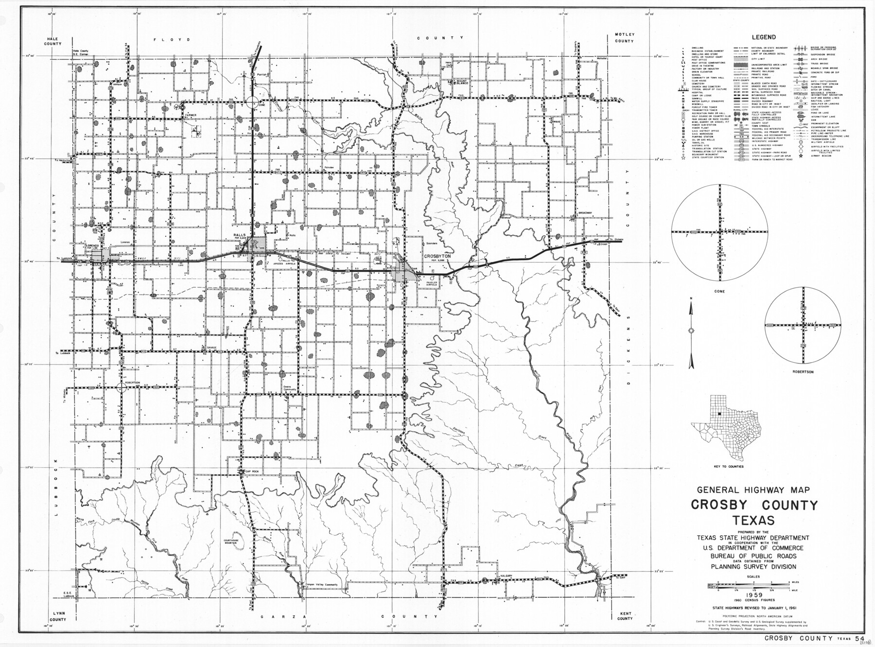
General Highway Map, Crosby County, Texas
-
Map/Doc
79426
-
Collection
Texas State Library and Archives
-
Object Dates
1961 (Creation Date)
-
People and Organizations
Texas State Highway Department (Publisher)
-
Counties
Crosby
-
Subjects
County
-
Height x Width
18.1 x 24.5 inches
46.0 x 62.2 cm
-
Comments
Prints available courtesy of the Texas State Library and Archives.
More info can be found here: TSLAC Map 05102
Part of: Texas State Library and Archives
Map of Texas to Accompany Granger's Southern and Western Texas Guide

Print $20.00
Map of Texas to Accompany Granger's Southern and Western Texas Guide
1878
Size 26.4 x 20.4 inches
Map/Doc 76235
General Highway Map, Orange County, Texas

Print $20.00
General Highway Map, Orange County, Texas
1940
Size 18.3 x 24.5 inches
Map/Doc 79212

General Highway Map, Maverick County, Texas

Print $20.00
General Highway Map, Maverick County, Texas
1961
Size 18.2 x 24.6 inches
Map/Doc 79587
General Highway Map, Chambers County, Texas

Print $20.00
General Highway Map, Chambers County, Texas
1961
Size 18.3 x 24.8 inches
Map/Doc 79404
General Highway Map, Burnet County, Texas

Print $20.00
General Highway Map, Burnet County, Texas
1940
Size 18.4 x 25.0 inches
Map/Doc 79035
General Highway Map, Fort Bend County, Texas

Print $20.00
General Highway Map, Fort Bend County, Texas
1961
Size 18.1 x 24.5 inches
Map/Doc 79469
General Highway Map, Jones County, Texas

Print $20.00
General Highway Map, Jones County, Texas
1961
Size 18.2 x 24.5 inches
Map/Doc 79546
General Highway Map, Roberts County, Texas

Print $20.00
General Highway Map, Roberts County, Texas
1940
Size 18.4 x 25.0 inches
Map/Doc 79229
General Highway Map, Llano County, Texas

Print $20.00
General Highway Map, Llano County, Texas
1961
Size 18.2 x 24.6 inches
Map/Doc 79576
General Highway Map, Burnet County, Texas

Print $20.00
General Highway Map, Burnet County, Texas
1961
Size 18.0 x 24.6 inches
Map/Doc 79392

You may also like
Mason County Rolled Sketch 4

Print $20.00
- Digital $50.00
Mason County Rolled Sketch 4
1983
Size 23.3 x 26.9 inches
Map/Doc 6677
Pecos County Rolled Sketch 168

Print $40.00
- Digital $50.00
Pecos County Rolled Sketch 168
Size 73.5 x 44.7 inches
Map/Doc 9748
Planiglobii Terrestris Mappa Universalis Utrumqs Hemisphaerium Orient et Occidentale

Print $20.00
- Digital $50.00
Planiglobii Terrestris Mappa Universalis Utrumqs Hemisphaerium Orient et Occidentale
1746
Size 21.4 x 24.4 inches
Map/Doc 96580
Guadalupe County Sketch File 15b

Print $4.00
- Digital $50.00
Guadalupe County Sketch File 15b
1873
Size 10.3 x 8.4 inches
Map/Doc 24691
[Rio Grande & Eagle Pass - Stockdale to Cuero]
![64049, [Rio Grande & Eagle Pass - Stockdale to Cuero], General Map Collection](https://historictexasmaps.com/wmedia_w700/maps/64049.tif.jpg)
Print $40.00
- Digital $50.00
[Rio Grande & Eagle Pass - Stockdale to Cuero]
Size 19.1 x 98.7 inches
Map/Doc 64049
Webb County Rolled Sketch 50

Print $20.00
- Digital $50.00
Webb County Rolled Sketch 50
1943
Size 38.2 x 42.6 inches
Map/Doc 10125
Flight Mission No. DQN-1K, Frame 142, Calhoun County

Print $20.00
- Digital $50.00
Flight Mission No. DQN-1K, Frame 142, Calhoun County
1953
Size 18.8 x 22.3 inches
Map/Doc 84205
Jim Hogg County Sketch File 10

Print $22.00
- Digital $50.00
Jim Hogg County Sketch File 10
1947
Size 14.3 x 8.7 inches
Map/Doc 28423
[Missouri, Kansas & Texas Line Map through Bastrop County]
![64029, [Missouri, Kansas & Texas Line Map through Bastrop County], General Map Collection](https://historictexasmaps.com/wmedia_w700/maps/64029.tif.jpg)
Print $40.00
- Digital $50.00
[Missouri, Kansas & Texas Line Map through Bastrop County]
1916
Size 25.8 x 122.6 inches
Map/Doc 64029
Cooke County Working Sketch 24

Print $20.00
- Digital $50.00
Cooke County Working Sketch 24
1972
Size 22.1 x 24.4 inches
Map/Doc 68261
Flight Mission No. DAG-21K, Frame 118, Matagorda County

Print $20.00
- Digital $50.00
Flight Mission No. DAG-21K, Frame 118, Matagorda County
1952
Size 18.5 x 18.4 inches
Map/Doc 86443
[K. N. Hapgood's Pasture and surrounding surveys]
![90432, [K. N. Hapgood's Pasture and surrounding surveys], Twichell Survey Records](https://historictexasmaps.com/wmedia_w700/maps/90432-1.tif.jpg)
Print $2.00
- Digital $50.00
[K. N. Hapgood's Pasture and surrounding surveys]
1923
Size 8.7 x 11.5 inches
Map/Doc 90432