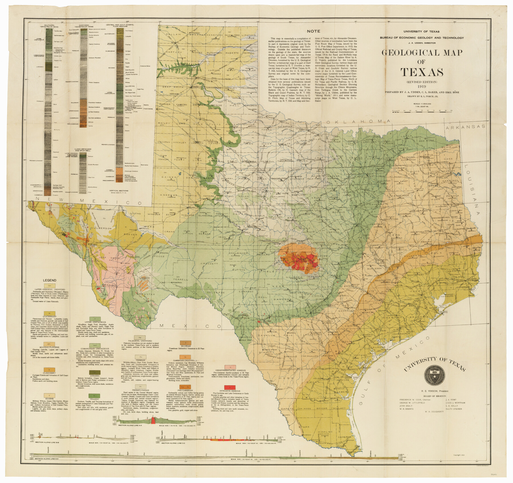
Geological Map of Texas
(Revised Edition)
-
Map/Doc
94091
-
Collection
General Map Collection
-
Object Dates
1919 (Creation Date)
-
People and Organizations
University of Texas, Bureau of Economic Geology (Publisher)
J.A. Udden (Author)
C.L. Baker (Author)
Emil Böse (Author)
E.L. Porch Jr. (Draftsman)
-
Subjects
State of Texas
-
Height x Width
34.9 x 36.8 inches
88.7 x 93.5 cm
-
Medium
paper, etching/engraving/lithograph
-
Scale
1 in = 23.67 miles
Part of: General Map Collection
Terrell County Sketch File 10

Print $44.00
- Digital $50.00
Terrell County Sketch File 10
1902
Size 9.7 x 4.6 inches
Map/Doc 37910
Kimble County Working Sketch 57

Print $20.00
- Digital $50.00
Kimble County Working Sketch 57
1958
Size 20.3 x 30.5 inches
Map/Doc 70125
Moore County Working Sketch 4

Print $20.00
- Digital $50.00
Moore County Working Sketch 4
1911
Size 20.1 x 15.6 inches
Map/Doc 71186
Shackelford County Rolled Sketch 7

Print $20.00
- Digital $50.00
Shackelford County Rolled Sketch 7
2009
Size 36.9 x 24.8 inches
Map/Doc 89229
Tom Green County Sketch File 81

Print $20.00
- Digital $50.00
Tom Green County Sketch File 81
Size 16.6 x 23.4 inches
Map/Doc 12453
Montague County Working Sketch 28

Print $20.00
- Digital $50.00
Montague County Working Sketch 28
1963
Size 36.6 x 31.8 inches
Map/Doc 71094
Clay County Working Sketch 10
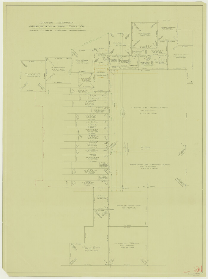
Print $20.00
- Digital $50.00
Clay County Working Sketch 10
1941
Size 35.5 x 26.5 inches
Map/Doc 68033
Shackelford County Working Sketch 5

Print $20.00
- Digital $50.00
Shackelford County Working Sketch 5
1936
Size 22.5 x 31.6 inches
Map/Doc 63845
Jackson County Sketch File 21a

Print $20.00
- Digital $50.00
Jackson County Sketch File 21a
1937
Size 25.7 x 35.4 inches
Map/Doc 11843
Webb County Rolled Sketch 68

Print $43.00
- Digital $50.00
Webb County Rolled Sketch 68
1910
Size 9.6 x 15.1 inches
Map/Doc 49485
Copy of Surveyor's Field Book, Morris Browning - In Blocks 7, 5 & 4, I&GNRRCo., Hutchinson and Carson Counties, Texas

Print $2.00
- Digital $50.00
Copy of Surveyor's Field Book, Morris Browning - In Blocks 7, 5 & 4, I&GNRRCo., Hutchinson and Carson Counties, Texas
1888
Size 7.0 x 8.8 inches
Map/Doc 62265
Carte de la Louisiane cours du Mississipi et pais voisins dediée à M. le Comte de Maurepas, Ministre et Secretaire d'Etat Commandeur des Ordres du Roy

Print $20.00
- Digital $50.00
Carte de la Louisiane cours du Mississipi et pais voisins dediée à M. le Comte de Maurepas, Ministre et Secretaire d'Etat Commandeur des Ordres du Roy
1744
Size 17.5 x 23.3 inches
Map/Doc 94496
You may also like
Jasper County Sketch File 22

Print $4.00
- Digital $50.00
Jasper County Sketch File 22
1910
Size 8.8 x 7.7 inches
Map/Doc 27822
[I. & G. N. Block 1, sections 57-70]
![89833, [I. & G. N. Block 1, sections 57-70], Twichell Survey Records](https://historictexasmaps.com/wmedia_w700/maps/89833-1.tif.jpg)
Print $20.00
- Digital $50.00
[I. & G. N. Block 1, sections 57-70]
Size 42.0 x 36.5 inches
Map/Doc 89833
Bailey County Working Sketch 4

Print $20.00
- Digital $50.00
Bailey County Working Sketch 4
1937
Size 27.0 x 32.0 inches
Map/Doc 67591
Montgomery County Working Sketch 72

Print $20.00
- Digital $50.00
Montgomery County Working Sketch 72
1979
Size 17.2 x 32.4 inches
Map/Doc 71179
University Lands as resurveyed by Frank F. Friend, Special Surveyor, San Angelo, Texas projected on a map of the State of Texas

Print $40.00
- Digital $50.00
University Lands as resurveyed by Frank F. Friend, Special Surveyor, San Angelo, Texas projected on a map of the State of Texas
1936
Size 31.0 x 55.8 inches
Map/Doc 2418
Dimmit County Working Sketch 15

Print $20.00
- Digital $50.00
Dimmit County Working Sketch 15
1942
Size 19.0 x 34.5 inches
Map/Doc 68676
Rockwall County Boundary File 2

Print $12.00
- Digital $50.00
Rockwall County Boundary File 2
Size 14.4 x 8.9 inches
Map/Doc 58385
Current Miscellaneous File 29

Print $10.00
- Digital $50.00
Current Miscellaneous File 29
Size 11.2 x 8.8 inches
Map/Doc 73920
Kinney County Working Sketch 17

Print $20.00
- Digital $50.00
Kinney County Working Sketch 17
1947
Size 29.4 x 38.7 inches
Map/Doc 70199
Flight Mission No. DAG-23K, Frame 165, Matagorda County

Print $20.00
- Digital $50.00
Flight Mission No. DAG-23K, Frame 165, Matagorda County
1953
Size 17.0 x 19.0 inches
Map/Doc 86503
Flight Mission No. CGI-4N, Frame 186, Cameron County

Print $20.00
- Digital $50.00
Flight Mission No. CGI-4N, Frame 186, Cameron County
1955
Size 18.5 x 22.2 inches
Map/Doc 84689
Presidio County Rolled Sketch 95

Print $20.00
- Digital $50.00
Presidio County Rolled Sketch 95
1949
Size 45.4 x 37.5 inches
Map/Doc 9781