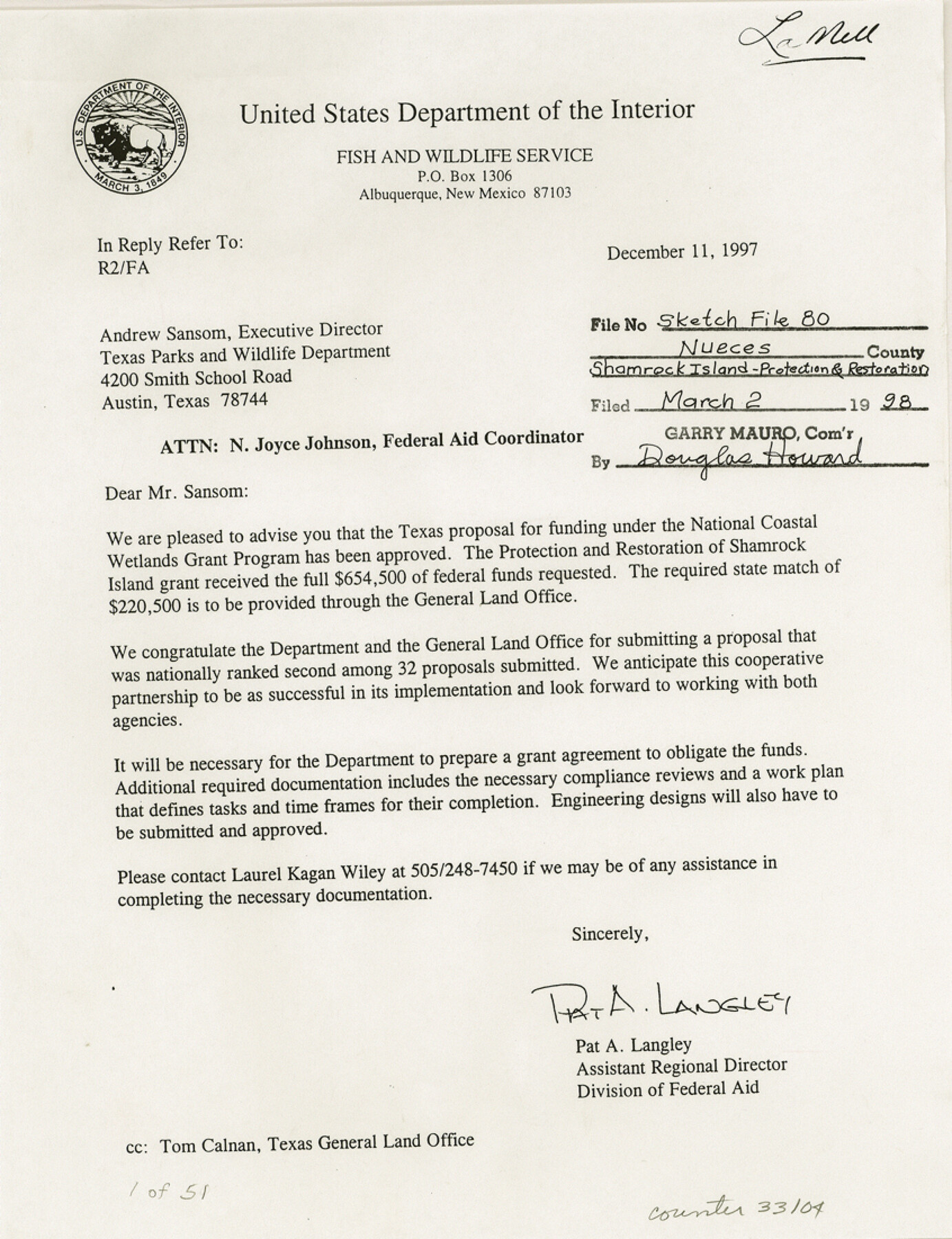
Nueces County Sketch File 80
[Memorandum of understanding between U. S. Fish and Wildlife service and the Texas General Land Office in cooperating in "Adopt-a-Habitat" program]
-
Map/Doc
33104
-
Collection
General Map Collection
-
Object Dates
12/11/1997 (Creation Date)
3/2/1998 (File Date)
12/11/1997 (Correspondence Date)
8/25/1997 (Correspondence Date)
8/22/1997 (Correspondence Date)
8/28/1996 (Correspondence Date)
-
People and Organizations
Pat A. Langley (Agent)
Robert J. Potts (Agent)
Scott Hedges (Agent)
Ray Allen (Agent)
John M. Cherry (President)
Lee F. Elliott (Agent)
-
Counties
Nueces
-
Subjects
Surveying Sketch File
-
Height x Width
11.0 x 8.5 inches
27.9 x 21.6 cm
-
Medium
paper, print
-
Features
Shamrock Island
Corpus Christi
Port Aransas
Mustang Island
Corpus Christi Bay
Redfish Bay
Mustang Island State Park
Nueces Bay
Shamrock Point
Aransas Pass
Chiltipin Creek
Shamrock Island
Mustang Island
Corpus Christi
Part of: General Map Collection
Sutton County Rolled Sketch 62

Print $40.00
- Digital $50.00
Sutton County Rolled Sketch 62
Size 69.8 x 45.2 inches
Map/Doc 9978
Flight Mission No. DIX-6P, Frame 190, Aransas County

Print $20.00
- Digital $50.00
Flight Mission No. DIX-6P, Frame 190, Aransas County
1956
Size 18.8 x 22.7 inches
Map/Doc 83852
Childress County Sketch File 13

Print $12.00
- Digital $50.00
Childress County Sketch File 13
1896
Size 6.4 x 8.7 inches
Map/Doc 18266
Wharton County Working Sketch 3

Print $20.00
- Digital $50.00
Wharton County Working Sketch 3
Size 17.5 x 16.4 inches
Map/Doc 72467
Harris County Sketch File 29

Print $15.00
- Digital $50.00
Harris County Sketch File 29
Size 14.1 x 9.0 inches
Map/Doc 25409
Reeves County Sketch File 7

Print $20.00
- Digital $50.00
Reeves County Sketch File 7
Size 18.3 x 19.9 inches
Map/Doc 12243
Comal County Sketch File 17

Print $2.00
- Digital $50.00
Comal County Sketch File 17
Size 8.7 x 8.9 inches
Map/Doc 19036
Trinity County Sketch File 16

Print $4.00
- Digital $50.00
Trinity County Sketch File 16
1879
Size 8.2 x 11.1 inches
Map/Doc 38544
Amerique Septentrionale

Print $20.00
- Digital $50.00
Amerique Septentrionale
1650
Size 17.2 x 23.1 inches
Map/Doc 93684
Travis County Rolled Sketch 13

Print $20.00
- Digital $50.00
Travis County Rolled Sketch 13
Size 28.0 x 20.4 inches
Map/Doc 8016
Pecos County Sketch File 97

Print $6.00
- Digital $50.00
Pecos County Sketch File 97
1957
Size 11.4 x 17.2 inches
Map/Doc 34000
Brazoria County Rolled Sketch 25B

Print $261.00
- Digital $50.00
Brazoria County Rolled Sketch 25B
Size 28.0 x 15.8 inches
Map/Doc 42752
You may also like
Crockett County Working Sketch 68

Print $40.00
- Digital $50.00
Crockett County Working Sketch 68
1959
Size 23.7 x 55.6 inches
Map/Doc 68401
Lee County Sketch File 4

Print $4.00
- Digital $50.00
Lee County Sketch File 4
1859
Size 9.5 x 8.1 inches
Map/Doc 29682
[Victor Blanco's survey along the San Antonio River]
![187, [Victor Blanco's survey along the San Antonio River], General Map Collection](https://historictexasmaps.com/wmedia_w700/maps/187.tif.jpg)
Print $2.00
- Digital $50.00
[Victor Blanco's survey along the San Antonio River]
Size 11.2 x 8.2 inches
Map/Doc 187
Map of Armstrong County

Print $20.00
- Digital $50.00
Map of Armstrong County
1886
Size 23.0 x 18.6 inches
Map/Doc 3244
Map of Hale County

Print $40.00
- Digital $50.00
Map of Hale County
1900
Size 49.3 x 41.0 inches
Map/Doc 4691
Midland County Working Sketch 29

Print $40.00
- Digital $50.00
Midland County Working Sketch 29
1971
Size 49.4 x 35.6 inches
Map/Doc 71010
Galveston County Rolled Sketch Z61

Print $20.00
- Digital $50.00
Galveston County Rolled Sketch Z61
1934
Size 34.9 x 23.0 inches
Map/Doc 5993
Flight Mission No. CRC-3R, Frame 6, Chambers County

Print $20.00
- Digital $50.00
Flight Mission No. CRC-3R, Frame 6, Chambers County
1956
Size 18.6 x 22.3 inches
Map/Doc 84780
Marion County Working Sketch 37

Print $20.00
- Digital $50.00
Marion County Working Sketch 37
1986
Size 30.0 x 43.0 inches
Map/Doc 70813
Edwards County Working Sketch 111

Print $40.00
- Digital $50.00
Edwards County Working Sketch 111
1972
Size 58.1 x 30.8 inches
Map/Doc 68987

Edwards County Rolled Sketch 29

Print $40.00
- Digital $50.00
Edwards County Rolled Sketch 29
1974
Size 49.1 x 29.1 inches
Map/Doc 8847